

Signal No. 2 up over 17 areas as Ramil maintains strength over Quezon
Tropical Cyclone Wind Signal No. 2 was raised over 17 areas on Sunday morning as Tropical Storm Ramil (international name: Fengshen) maintained its strength over the coastal waters of Alabat, Quezon, PAGASA said.
TCWS No. 2 is in effect over:
- The southeastern portion of Quirino (Nagtipunan, Maddela, Aglipay);
- the central and southern portions of Nueva Vizcaya (Alfonso Castañeda, Dupax del Sur, Dupax del Norte, Bambang, Aritao, Kayapa, Santa Fe, Kasibu);
- the central and southern portions of Benguet (Itogon, Bokod, Atok, Kapangan, Tublay, La Trinidad, Baguio City, Tuba, Sablan)
- the central and southern portions of La Union (Rosario, Pugo, Tubao, Santo Tomas, Agoo, Aringay, Caba, Naguilian, Burgos, Bagulin, Bauang, City of San Fernando, San Juan, San Gabriel, Bacnotan, Santol, Balaoan, Luna);
- Pangasinan;
- Aurora;
- Nueva Ecija;
- Bulacan;
- Tarlac;
- Pampanga;
- the northern and central portions of Zambales (Santa Cruz, Candelaria, Masinloc, Palauig, Iba, Botolan, Cabangan);
- the northern portion of Metro Manila (Caloocan City, Quezon City, City of Valenzuela, City of Marikina, City of Malabon, City of Navotas);
- the northern and central portions of Rizal (Rodriguez, San Mateo, City of Antipolo, Tanay, Baras);
- the northern portion of Laguna (Santa Maria, Famy, Siniloan);
- the northern and eastern portions of Quezon (General Nakar, Calauag, Tagkawayan, Guinayangan, Quezon, Alabat, Perez, Mauban, Real, Infanta, Atimonan, Plaridel, Gumaca, Lopez) including Pollilo Islands;
- Camarines Norte; and
- the northwestern portion of Camarines Sur (Del Gallego, Ragay, Lupi, Sipocot).
Areas under TCWS No. 2 will have gale-force winds ranging from 62 to 88 km/h in speed in 24 hours, which may pose minor to moderate threat to life and property.
TCWS No. 1 meanwhile was raised over the following:
- Cagayan including Babuyan Islands;
- Isabela;
- the rest of Quirino;
- the rest of Nueva Vizcaya;
- Apayao;
- Abra;
- Kalinga;
- Mountain Province;
- Ifugao;
- the rest of Benguet;
- Ilocos Norte;
- Ilocos Sur;
- the rest of La Union;
- the rest of Zambales;
- Bataan;
- the rest of Metro Manila;
- the rest of Quezon;
- the rest of Rizal;
- the rest of Laguna;
- Cavite;
- Batangas;
- Occidental Mindoro including Lubang Islands;
- Oriental Mindoro;
- Marinduque;
- Romblon;
- the rest of Camarines Sur;
- Catanduanes;
- Albay;
- Sorsogon;
- the northern and central portions of Masbate (Aroroy, Baleno, Mandaon, Milagros, Balud, City of Masbate, Mobo, Uson, Dimasalang, Palanas, Cawayan) including Ticao and Burias Islands;
- Northern Samar;
- the northern portion of Eastern Samar (Jipapad, San Policarpo, Oras, Arteche, Maslog); and
- the northern portion of Samar (Matuguinao, Calbayog City, Gandara, Santa Margarita, Pagsanghan, Tagapul-An, Almagro, Santo Niño, San Jose de Buan).
The above mentioned areas under TCWS No. 1 may expect strong winds with speeds of 39 to 61 km/h in 36 hours, potentially posing minimal to minor threat to life and property.
Location
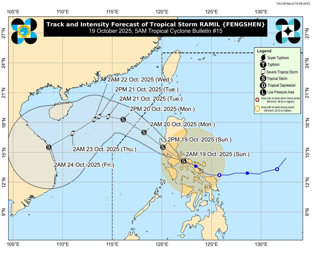
At 4 a.m., the center of Ramil was estimated to be located over the coastal waters of Alabat, Quezon.
Ramil has maximum sustained winds of 65 km/h near the center, gustiness of up to 90 km/h, and central pressure of 998 hPa.
It is moving west northwestward at 25 km/h.
From the storm's center, strong to gale-force winds are extending outwards up to 430 km.
Rains
Forecast rainfall for Sunday by PAGASA is as follows:
• 100 to 200 mm of rain:
Camarines Norte, Romblon, Marinduque, Oriental Mindoro, Occidental Mindoro, Quezon, Batangas, Aurora, Quirino, Nueva Vizcaya, Aklan, and Antique
• 50 to 100 mm of rain:
Cagayan, Kalinga, Mountain Province, Ifugao, and Isabela, Ilocos Sur, Ilocos Norte, Apayao, Abra, Benguet, La Union, Pangasinan, Zambales, Bataan, Tarlac, Nueva Ecija, Bulacan, Pampanga, Metro Manila, Rizal, Laguna, Cavite, Sorsogon, Albay, Catanduanes, Camarines Sur, Masbate, Iloilo, Capiz, and Palawan
Winds
The easterlies and Ramil's trough or extension and outer rainbands will cause strong to gale-force gusts over Cagayan Valley, Oriental Mindoro, Masbate, Caluya Islands, Samar, Eastern Samar, and Biliran, especially in coastal and upland areas exposed to winds.
Storm surge
PAGASA said a minimal to moderate risk of storm surge with waves reaching up to 2.0 meters within 36 hours may affect the low-lying or exposed coastal localities of Isabela, Ilocos Norte, Ilocos Sur, La Union, Pangasinan, Zambales, Aurora, Quezon, Marinduque, Camarines Norte, Camarines Sur, Catanduanes, Albay, and Masbate.
Gale warning
PAGASA raised a gale warning over the eastern and western seaboards of Luzon.
The seaboards of Isabela, Aurora, Camarines Norte, and Polillo Islands; the western seaboards of Pangasinan, Zambales, Bataan, and Batangas; the northwestern seaboard of Occidental Mindoro including Lubang Island will have up to very rough seas with up to 4.5 m-high waves.
"Sea travel is risky for all types or tonnage of vessels. All mariners must remain in port or, if underway, seek shelter or safe harbor as soon as possible until winds and waves subside," PAGASA said.
Up to rough seas meanwhile are forecast over the following coastal waters:
• Up to 3.5 m: The northern seaboards of Camarines Sur; the northern and eastern seaboards of Catanduanes; the northern seaboards of mainland Quezon; the eastern seaboard of mainland Cagayan
• Up to 3.0 m: The seaboards of Batanes; the remaining seaboards of mainland Cagayan and Babuyan Islands; the seaboards of Ilocos Norte and Ilocos Sur; the eastern seaboards of Albay and Sorsogon
"Mariners of small seacrafts, including all types of motorbancas, are advised not to venture out to sea under these conditions, especially if inexperienced of operating ill-equipped vessels," PAGASA said.
The following coastal waters meanwhile may have up to moderate seas:
• Up to 2.5 m: The seaboard of La Union; and the remaining seaboards of Pangasinan and Quezon.
• Up to 2.0 m: The seaboard of Marinduque; the remaining seaboards of Bicol Region; the northern and eastern seaboards of Northern Samar.
"Mariners of motorbancas and similarly sized vessels are advised to take precautionary measures while venturing out to sea and, if possible, avoid navigation under these conditions," PAGASA said.
Track, intensity
"Heavy rainfall, severe winds, and storm surge may still be experienced in localities outside the landfall point and the forecast confidence cone," the weather bureau said.
Ramil is forecast to move west northwestward or northwestward as it makes landfall over Quezon on Sunday morning.
"After making landfall, it will traverse the Southern-Central Luzon landmass before emerging over the coastal waters of Pangasinan or Zambales this afternoon or evening," PAGASA said.
It will then continue northwestward then exit the Philippine Area of Responsibility on Monday morning or noon.
The next tropical cyclone bulletin will be issued by PAGASA at 8 a.m. —KG, GMA Integrated News
