

17 Luzon areas under Signal No. 2 as Ramil further moves west northwest
Tropical Cyclone Wind Signal No. 2 was hoisted over 17 Luzon areas as Tropical Storm Ramil (international name: Fengshen) continues to move west northwestward while over the coastal waters of Quezon, PAGASA said Sunday morning.
Based on PAGASA's 8 a.m. weather bulletin, the following areas are under TCWS No. 2:
- southeastern portion of Quirino (Nagtipunan, Maddela, Aglipay);
- central and southern portions of Nueva Vizcaya (Alfonso Castañeda, Dupax del Sur, Dupax del Norte, Bambang, Aritao, Kayapa, Santa Fe, Kasibu);
- central and southern portions of Benguet (Itogon, Bokod, Atok, Kapangan, Tublay, La Trinidad, Baguio City, Tuba, Sablan);
- central and southern portions of La Union (Rosario, Pugo, Tubao, Santo Tomas, Agoo, Aringay, Caba, Naguilian, Burgos, Bagulin, Bauang, City of San Fernando, San Juan, San Gabriel, Bacnotan, Santol, Balaoan, Luna);
- Pangasinan;
- Aurora;
- Nueva Ecija;
- Bulacan;
- Tarlac;
- Pampanga;
- northern and central portions of Zambales (Santa Cruz, Candelaria, Masinloc, Palauig, Iba, Botolan, Cabangan);
- northern portion of Metro Manila (Caloocan City, Quezon City, City of Valenzuela, City of Marikina, City of Malabon, City of Navotas);
- northern and central portions of Rizal (Rodriguez, San Mateo, City of Antipolo, Tanay, Baras);
- northern portion of Laguna (Santa Maria, Famy, Siniloan);
- northern and eastern portions of Quezon (General Nakar, Calauag, Tagkawayan, Guinayangan, Quezon, Alabat, Perez, Mauban, Real, Infanta, Atimonan, Plaridel, Gumaca, Lopez) including Pollilo Islands;
- Camarines Norte; and
- northwestern portion of Camarines Sur (Del Gallego, Ragay, Lupi, Sipocot).
TCWS No. 1 meanwhile is up over the following areas:
- Cagayan including Babuyan Islands;
- Isabela;
- the rest of Quirino;
- the rest of Nueva Vizcaya;
- Apayao;
- Abra;
- Kalinga;
- Mountain Province;
- Ifugao;
- the rest of Benguet;
- Ilocos Norte;
- Ilocos Sur;
- the rest of La Union;
- the rest of Zambales;
- Bataan;
- the rest of Metro Manila;
- the rest of Quezon;
- the rest of Rizal;
- the rest of Laguna;
- Cavite;
- Batangas;
- Occidental Mindoro including Lubang Islands;
- Oriental Mindoro;
- Marinduque;
- Romblon;
- the rest of Camarines Sur;
- Catanduanes;
- Albay;
- the central and western portions of Sorsogon (City of Sorsogon, Magallanes, Pilar, Castilla, Casiguran, Donsol, Juban, Bulan); and
- the northern portion of Masbate (Aroroy, Baleno, Mandaon) including Ticao and Burias Islands.
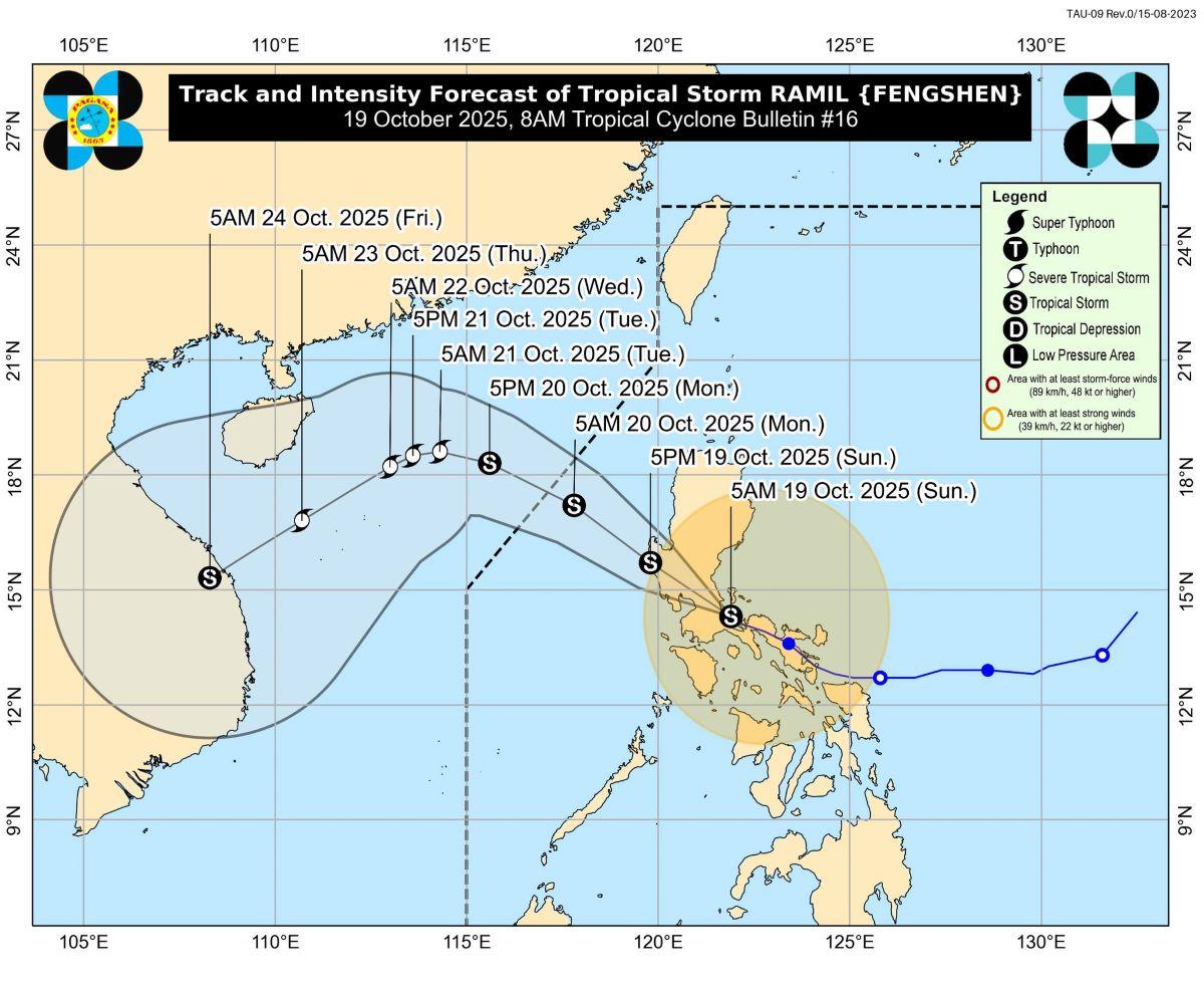
At 7 a.m., Ramil's center was estimated to be located over the coastal waters of Mauban, Quezon, carrying maximum sustained winds of 65 km/h near the center and gusts of up to 90 km/h, and is moving west northwestward at 20 km/h.
State meteorologists said on Sunday, the trough and outer rainbands of Ramil and the easterlies will bring strong to gale-force gusts over Cagayan Valley, Oriental Mindoro, Masbate, Caluya Islands, Samar, Northern Samar, Samar, Eastern Samar, and Biliran, which are not under any TCWS.
Meanwhile, a minimal to moderate risk of storm surge with peak heights of 1.0 to 2.0 m is expected within 24 hours over the low-lying or exposed coastal localities of Aurora, Quezon, Camarines Sur, Ilocos Sur, La Union, Pangasinan, Zambales, Bataan, Batangas, Cavite, Marinduque, and Occidental Mindoro.
“It must be emphasized that heavy rainfall, severe winds, and storm surge may still be experienced in localities outside the landfall point and the forecast confidence cone,” PAGASA said.
The state weather bureau also said Ramil will be moving west northwestward or northwestward as it makes landfall over the vicinity of Quezon Province this morning.
“After making landfall, it will traverse the Southern-Central Luzon landmass before emerging over the coastal waters of Pangasinan or Zambales this afternoon,” PAGASA explained.
“It will then continue moving generally northwestward until it exits the Philippine Area of Responsibility (PAR) tomorrow (20 October) morning or noon,” it added.
Ramil is expected to maintain its strength or slightly weaken due to frictional effects of mountainous terrain.
“Once over the West Philippine Sea, further re-intensification is highly likely, with Ramil expected to reach severe tropical storm category while outside the PAR Region,” PAGASA said.
Evacuations
Meanwhile, a total of 22,311 individuals or 7,884 families from Calabarzon and Region 5 were pre-emptively evacuated due to the expected effects of Ramil, the National Disaster Risk Reduction and Management Council said Sunday. —KG, GMA Integrated News
