

Signal No. 4 in northern Palawan as Tino nears Cuyo Islands
The northern portion of Palawan has been placed under Signal No. 4 as Typhoon Tino approached Cuyo Island, PAGASA said Tuesday evening.
At 7 p.m., Tino was located over the coastal waters of Magsaysay, Palawan, with maximum sustained winds of 130 km/h near the center and gusts of up to 180 km/h, and is moving westward at 25 km/h.
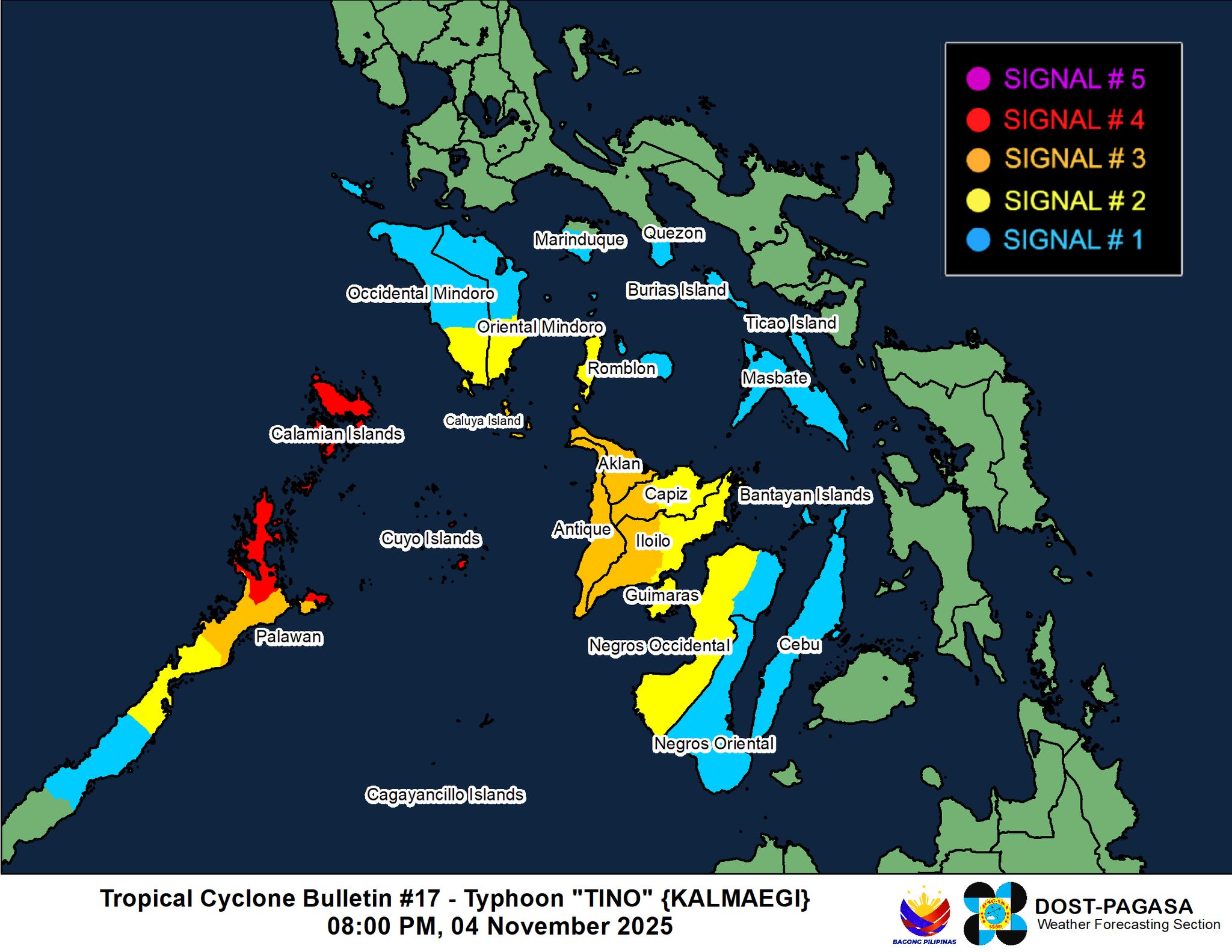
Based on PAGASA’s 8 p.m. weather bulletin, Signal No. 4 is hoisted in the northernmost portion of Palawan (El Nido, Taytay, Araceli), including Calamian and Cuyo Islands.
The following are under Signal No. 3:
Luzon
- The northern portion of Palawan (Dumaran, San Vicente, Roxas)
Visayas
- Aklan
- Antique, including Caluya Islands
- The western portion of Capiz (Jamindan, Tapaz)
- The western portion of Iloilo (Lambunao, Calinog, New Lucena, Oton, Pavia, Dueñas, Mina, Santa Barbara, Bingawan, Badiangan, Maasin, San Miguel, Cabatuan, Alimodian, Janiuay, Leon, Guimbal, Tigbauan, Igbaras, Tubungan, Miagao, San Joaquin)
Signal No. 2 is up in the following areas:
Luzon
- The western portion of Romblon (Santa Fe, Santa Maria, Looc, Alcantara, Odiongan, San Jose, Ferrol, San Andres, Calatrava, San Agustin)
- The southern portion of Oriental Mindoro (Bulalacao, Mansalay, Roxas, Bongabong)
- The southern portion of Occidental Mindoro (Magsaysay, San Jose, Rizal, Calintaan)
- The central portion of Palawan (Puerto Princesa City)
Visayas
- The rest of Capiz
- The rest of Iloilo, Guimaras
- The western portion of Negros Occidental (Cadiz City, City of Victorias, Manapla, Enrique B. Magalona, Silay City, City of Talisay, Bacolod City, Bago City, Pulupandan, Valladolid, La Carlota City, Pontevedra, San Enrique, Hinigaran, Murcia, Cauayan, City of Sipalay, Candoni, Ilog, City of Kabankalan, Hinoba-An, City of Himamaylan, Binalbagan, Isabela, Moises Padilla, La Castellana)
The following areas are under Signal No. 1:
Luzon
- The southern portion of Quezon (San Francisco, San Andres)
- The southern portion of Marinduque (Torrijos, Buenavista, Gasan, Boac)
- The rest of Romblon
- The rest of Oriental Mindoro
- The rest of Occidental Mindoro including Lubang Island
- The southern portion of Palawan (Aborlan, Quezon, Narra, Sofronio Española)
- Masbate including Burias and Ticao Islands
Visayas
- Cebu, including Bantayan Islands
- Negros Oriental
- The rest of Negros Occidental
PAGASA said on Wednesday, the surge of the Northeast Monsoon (Amihan), the shear line, and the trough of Tino will bring strong to gale-force gusts over Luzon, Western Visayas, Negros Island Region, Central Visayas, Biliran, Leyte, and Zamboanga Peninsula, which are not any under Wind Signal.
It warned that within the next 24 hours, a high risk of life-threatening and damaging storm surge with peak heights exceeding 3.0 m is expected over the low-lying or exposed coastal communities of Oriental Mindoro, Occidental Mindoro, Palawan, Capiz, Antique, Iloilo, Guimaras, and Negros Occidental.
A gale warning is in effect over the western and southern seaboards of Southern Luzon and the western seaboards of the Visayas.
PAGASA maintained that heavy rainfall, severe winds, and storm surge may be experienced in localities outside the landfall point and the forecast confidence cone.
Tino is expected to pass close to or make landfall over the Cuyo Islands tonight, then the Northern Palawan area by early Wednesday morning.
“It is expected to emerge over the West Philippine Sea tomorrow morning and may exit the Philippine Area of Responsibility by tomorrow evening or early Thursday morning,” PAGASA said.
“Tino is forecast to steadily re-intensify over the next days and may reach its peak intensity while over the West Philippine Sea,” it added. –NB, GMA Integrated News
