

Uwan enters PAR; Signal No. 1 up in parts of Luzon, Visayas, Mindanao
Typhoon Uwan is now inside the Philippine Area of Responsibility (PAR).
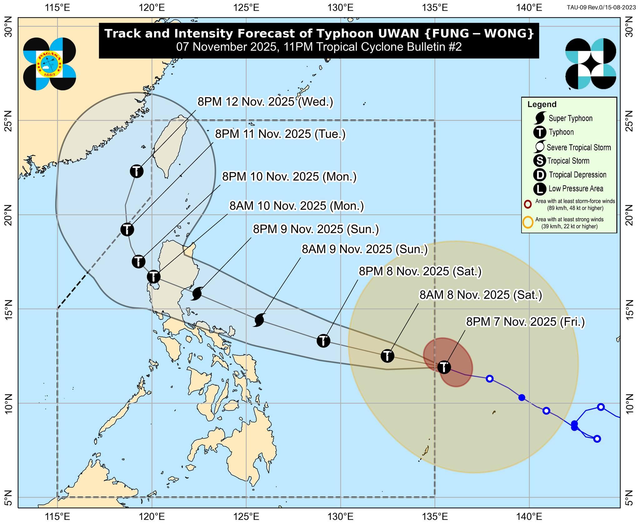
PAGASA said Uwan’s center entered the PAR at 10 p.m. Friday. It was located 1,045 km east of Eastern Visayas, packing maximum sustained winds of 120 km/h near the center and gusts of up to 150 km/h.
Uwan was moving west northwestward at 20 km/h.
According to its 11 p.m. tropical cyclone bulletin on Uwan, PAGASA raised Signal No. 1 over the following areas in Luzon, the Visayas, and Mindanao.
Luzon:
- the eastern portion of Isabela (Divilacan, Palanan, Dinapigue, San Mariano, San Guillermo, Echague, Jones, San Agustin)
- the eastern and southern portions of Quirino (Maddela, Nagtipunan)
- the southeastern portion of Nueva Vizcaya (Alfonso Castañeda)
- Aurora
- the southeastern portion of Rizal (Tanay, Pililla, Jala-Jala)
- the eastern portion of Laguna (Luisiana, Mabitac, Liliw, Majayjay, Paete, Pagsanjan, Rizal, Pangil, Santa Maria, Siniloan, Nagcarlan, Cavinti, Kalayaan, Lumban, Magdalena, Victoria, Pakil, Santa Cruz, Pila, Famy)
- the eastern and southern portions of Quezon (Tagkawayan, Guinayangan, Calauag, Lopez, Buenavista, Catanauan, Mulanay, San Narciso, San Andres, San Francisco, Pitogo, Lucena City, Pagbilao, Infanta, Unisan, General Luna, Plaridel, Quezon, Alabat, Lucban, Sampaloc, Padre Burgos, City of Tayabas, Macalelon, Mauban, General Nakar, Perez, Agdangan, Gumaca, Atimonan, Real, Sariaya, Candelaria) including Polillo Islands
- Romblon
- Marinduque
- Camarines Norte
- Camarines Sur
- Albay
- Catamarans
- Sorsogon
- Masbate including Ticao and Burias Islands
Visayas:
- Northern Samar
- Eastern Samar
- Samar
- Biliran
- Leyte
- Southern Leyte
- the northern and central portions of Cebu (Medellin, Daanbantayan, City of Bogo, Tabogon, San Remigio, Tabuelan, Borbon, Sogod, Tuburan, Catmon, Carmen, Danao City, Compostela, Liloan, Consolacion, Lapu-Lapu City, Mandaue City, Cordova, Asturias, Cebu City, Balamban, City of Talisay, Toledo City, Minglanilla) including Bantayan and Camotes Islands
- the northeastern portion of Bohol (Getafe, Talibon, Buenavista, Trinidad, San Miguel, Ubay, Alicia, Mabini, Bien Unido, Pres. Carlos P. Garcia)
- the northern portion of Negros Occidental (City of Escalante, Toboso, Sagay City, Cadiz City, Calatrava, Manapla, City of Victorias, Enrique B. Magalona, Silay City, City of Talisay)
- the northern portion of Iloilo (Carles, Estancia, Balasan, San Dionisio, Concepcion, Batad, Sara, Ajuy, Barotac Viejo, San Rafael, Lemery)
- the northeastern and western portions of Capiz (President Roxas, Pilar, Panay, Pontevedra, Ma-Ayon, Cuartero, Dumarao, Dao, Panitan, Roxas City, Ivisan, Sigma, Sapi-An, Mambusao, Dumalag, Jamindan)
- Aklan
Mindanao:
- Dinagat Islands
- Surigao del Norte
“The wind signals warn the public of the general wind threat over an area due to the tropical cyclone. Local winds may be slightly stronger/enhanced in coastal and upland/mountainous areas exposed to winds. Winds are less strong in areas sheltered from the prevailing wind direction,” PAGASA said.
“Minimal to minor impacts from strong winds are possible within any of the areas under Wind Signal No. 1. The highest Wind Signal that will likely be hoisted throughout [Typhoon Uwan’s] passage is Wind Signal No. 5,” it added.
Other areas currently not under any wind signals may still experience occasional gusty conditions reaching strong to gale-force strength.
Meanwhile, possible life-threatening and damaging storm surge with peak heights exceeding 3.0 m may be observed over the low-lying or exposed coastal communities of Quezon including Polillo Islands, Camarines Norte, Camarines Sur, Catanduanes, Albay, and Sorsgon within the next 48 hours.
A gale warning has been placed in effect over the eastern seaboards of Southern Luzon and Visayas.
“It must be emphasized that heavy rainfall, severe winds, and storm surge may still be experienced in localities outside the landfall point and the forecast confidence cone,” PAGASA said.
Uwan is expected to make landfall over the southern portion of Isabela or the northern portion of Aurora on Sunday late evening or on Monday early morning.
It is predicted to rapidly intensify into a super typhoon by Saturday evening or Sunday morning. —VBL/NB, GMA Integrated News
