

Signal No. 2 up in 7 areas as Ada slightly intensifies
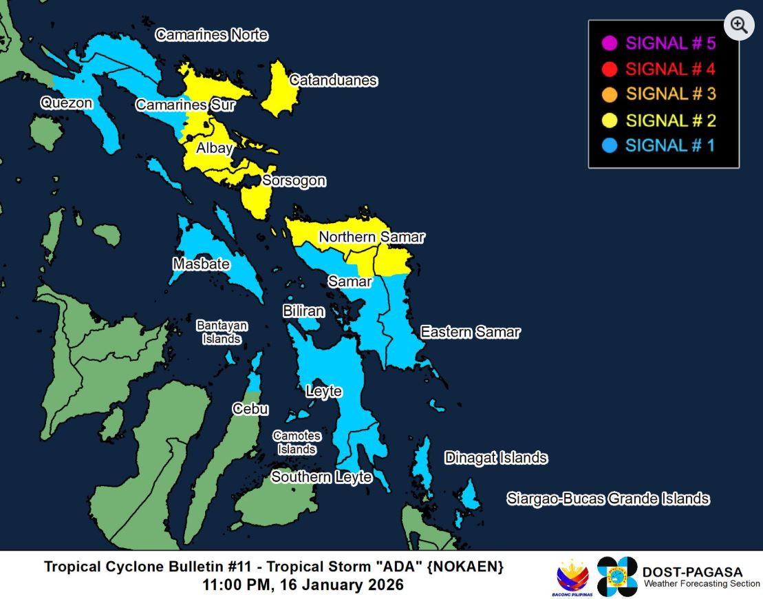
Seven areas have been placed under Signal No. 2 as Tropical Storm Ada slightly intensifies over the sea east of Eastern Visayas.
According to PAGASA’s 11 p.m. cyclone bulletin on Friday, the following areas under Signal No. 2 will experience winds of greater than 62 kph up to 88 kph within at least 24 hours:
- The eastern portion of Camarines Sur (Siruma, Tinambac, Ocampo, Baao, Nabua, Bato, Iriga City, Buhi, Sagñay, Tigaon, Goa, Lagonoy, San Jose, Garchitorena, Presentacion, Caramoan)
- Catanduanes
- Albay
- Sorsogon
- Northern Samar
- The northern portion of Eastern Samar (Jipapad, Maslog, Dolores, Oras, San Policarpo, Arteche)
- The northeastern portion of Samar (Matuguinao, San Jose de Buan)
The following areas under Signal no. 1 may also have winds of 39 to 61 kph or intermittent rains for at least 36 hours:
- The southern portion of Quezon (San Narciso, Mulanay, San Francisco, San Andres, Buenavista, Catanauan, Lopez, Calauag, Guinayangan, Tagkawayan, Quezon, Alabat, Gumaca, General Luna, Macalelon, Pitogo)
- Camarines Norte
- The rest of Camarines Sur
- Masbate including Ticao and Burias Islands
- The rest of Eastern Samar
- The rest of Samar
- Biliran
- Leyte
- Southern Leyte and the northern portion of Cebu (Medellin, Daanbantayan, San Remigio, City of Bogo, Tabogon) including Camotes and Bantayan Islands
- Dinagat Islands
- Siargao - Bucas Grande Islands
PAGASA noted that areas under Signal No. 2 may have minor to moderate impacts from gale-force winds, while areas under Signal No. 1 may have minimal to minor impacts from strong winds.
“The wind signals warn the public of the general wind threat over an area due to the tropical cyclone. Local winds may be slightly stronger/enhanced in coastal and upland/mountainous areas exposed to winds. Winds are less strong in areas sheltered from the prevailing wind direction,” read the advisory.
Tropical Storm Ada was last seen at 205 kilometers east of Catarman, Northern Samar, with maximum sustained winds of 75 kph and a gustiness of up to 90 kph.
PAGASA said that the center of Ada may pass close to Eastern Samar and Northern Samar on Saturday, and pass near Catanduanes from Saturday evening to Sunday.
A possible landfall scenario may occur Eastern Visayas and Bicol Region following possible changes in the forecast track.
Ada is predicted to remain a tropical storm over the sea east of Visayas and Southern Luzon before weakening into a tropical depression by Tuesday due to the effects of the surge of the Northeast Monsoon. —LDF, GMA Integrated News
