

Signal No. 2 up in 7 areas as Ada further intensifies
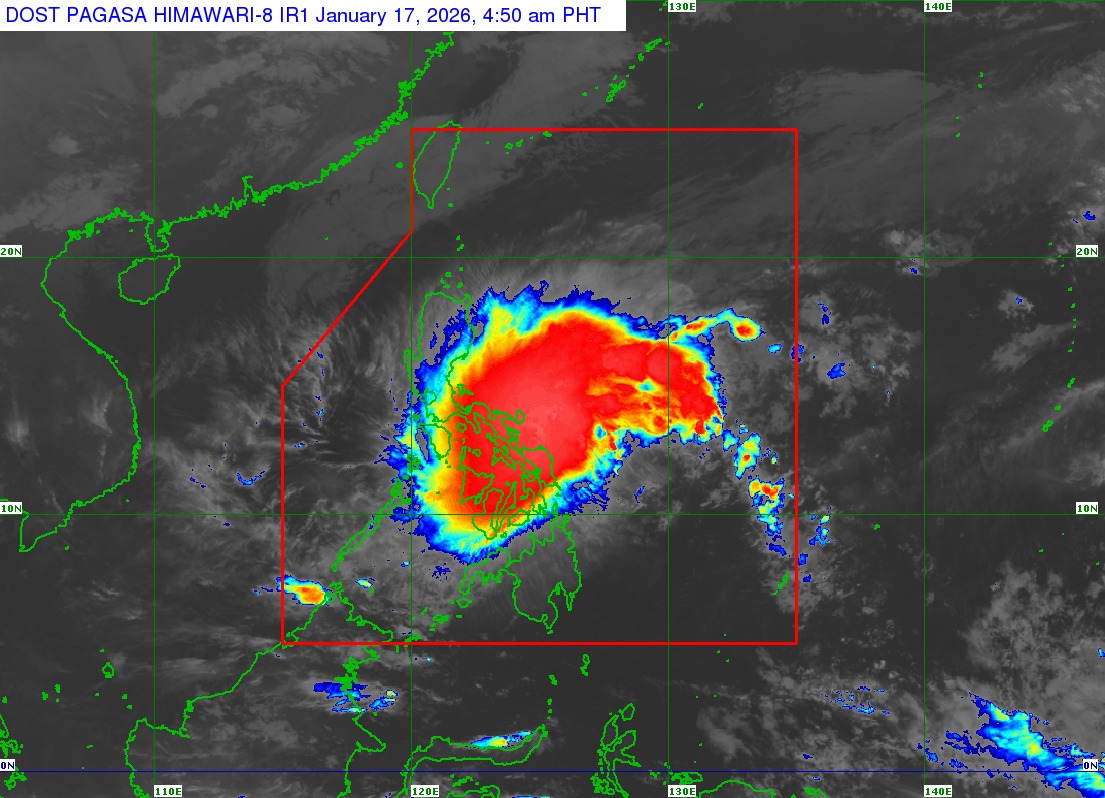
Tropical Storm Ada (international name: Nokaen) has further intensified while over the waters east of the Bicol Region, the state weather bureau PAGASA said in its early Saturday morning bulletin.
Tropical Cyclone Wind Signal No. 2 was raised over the following areas:
- the eastern portion of Camarines Sur (Siruma, Tinambac, Ocampo, Baao, Nabua, Bato, Iriga City, Buhi, Sagñay, Tigaon, Goa, Lagonoy, San Jose, Garchitorena, Presentacion, Caramoan, Milaor, Camaligan, Pili, Magarao, Minalabac, Balatan, Naga City, Calabanga, Bombon, Bula, Canaman, Gainza)
- Catanduanes
- Albay
- Sorsogon
- Northern Samar
- the northern portion of Eastern Samar (Jipapad, Maslog, Dolores, Oras, San Policarpo, Arteche)
- the northeastern portion of Samar (Matuguinao, San Jose de Buan)
Under Signal No. 1 are the following areas:
- the eastern portion of Quezon (Tagkawayan, Guinayangan, Lopez, Calauag, Buenavista, San Narciso, San Andres, San Francisco, Mulanay, Catanauan, General Luna, Macalelon, Gumaca, Pitogo, Unisan, Atimonan, Plaridel, Agdangan, Padre Burgos, Quezon, Alabat, Perez) including Polillo Islands
- Marinduque
- Camarines Norte
- the rest of Camarines Sur
- Masbate including Ticao and Burias Islands
- the rest of Eastern Samar
- the rest of Samar
- Biliran
- Leyte
- Southern Leyte
- the northern portion of Cebu (Medellin, Daanbantayan, San Remigio, City of Bogo, Tabogon) including Camotes and Bantayan Islands
"Since further intensification to severe tropical storm is not ruled out, raising of Wind Signal No. 3 is possible," PAGASA said in its 5 a.m. Saturday bulletin.
At 4 a.m., the center of Ada was located 120 km east northeast of Catarman, Northern Samar or 175 km east of Juban, Sorsogon. It has maximum sustained winds of 85 km/h near the center and gusts of up to 105 km/h.
Moving west northwestward at 20 km/h, Ada is expected to pass near Catanduanes between Saturday afternoon and early Sunday morning.
"A further westward shift in the forecast track may result in a possible landfall over [the] Bicol Region," PAGASA said.
PAGASA warned of a minimal to moderate risk of storm surge with peak heights reaching up to 2.0 meters within the next 48 hours over the low-lying or exposed coastal communities of Camarines Sur, Catanduanes, Albay, Sorsogon, Masbate, Northern Samar, Eastern Samar, Samar, Biliran, and Leyte.
The Northeast Monsoon and the periphery of Ada will also bring strong to gale-force gusts over Batanes, Babuyan Islands, northern and eastern mainland Cagayan, eastern Isabela, Ilocos Norte, Abra, Aurora, Quezon, Oriental Mindoro, Romblon, Marinduque, Cuyo Islands, Bicol Region, Visayas, Dinagat Islands, Camiguin, and Surigao del Norte on Saturday.
"Ada is forecast to remain a tropical storm category while moving over the sea east of Visayas and Southern Luzon," PAGASA said. "This tropical cyclone may then weaken into a tropical depression by Tuesday (January 20) due to the effects of the surge of the Northeast Monsoon."
Because of the tropical cyclone, classes at all levels in Naga City in Camarines Sur on Saturday were suspended.
Several domestic flights were canceled while sea travel was disrupted in various parts of the country.
The Office of Civil Defense said more precautions are needed in Albay due to the continuing unrest of Mayon Volcano and Ada .—VBL/KG, GMA Integrated News
