

4 areas still under Signal No. 2 due to Ada
Four areas remain under Signal No. 2 as Tropical Storm Ada continues to move over the coastal waters of Catanduanes.
In its 5 p.m. bulletin, PAGASA raised the following Tropical Cyclone Wind Signals:
Signal No. 2
- The eastern portion of Camarines Norte (Vinzons, San Lorenzo Ruiz, San Vicente, Talisay, Basud, Mercedes, Daet, Paracale)
- The eastern and central portions of Camarines Sur (Siruma, Tinambac, Ocampo, Goa, Lagonoy, Milaor, Nabua, Buhi, Caramoan, Baao, Cabusao, Bato, Camaligan, Pili, Sipocot, Tigaon, Pamplona, Garchitorena, Iriga City, San Fernando, Magarao, Minalabac, Balatan, Libmanan, Naga City, Calabanga, Bombon, Bula, Canaman, Pasacao, Sagñay, San Jose, Presentacion, Gainza, Lupi)
- Albay
- Catanduanes
Signal No. 1
- The southeastern portion of Isabela (Dinapigue, Palanan)
- Aurora
- The eastern portion of Quezon (Tagkawayan, Guinayangan, Lopez, Calauag, Buenavista, San Narciso, San Andres, San Francisco, Mulanay, Catanauan, General Luna, Macalelon, Gumaca, Pitogo, Unisan, Atimonan, Plaridel, Agdangan, Padre Burgos, Quezon, Alabat, Perez, General Nakar, Infanta, Real, Mauban) including Polillo Islands
- Marinduque
- The eastern portion of Romblon (Cajidiocan, Magdiwang, San Fernando)
- The rest of Camarines Norte
- The rest of Camarines Sur
- Sorsogon
- Masbate
- Northern Samar
- The northern and central portions of Eastern Samar (Can-Avid, Maslog, City of Borongan, San Policarpo, Taft, Dolores, Jipapad, Oras, Arteche, Sulat, San Julian)
- The northern and central portions of Samar (San Jorge, San Sebastian, Villareal, Zumarraga, Matuguinao, Pinabacdao, Almagro, Calbayog City, Talalora, Jiabong, Pagsanghan, City of Catbalogan, Gandara, Motiong, Santo Niño, Tagapul-An, San Jose de Buan, Santa Margarita, Tarangnan, Calbiga, Daram, Paranas, Hinabangan)
- Biliran
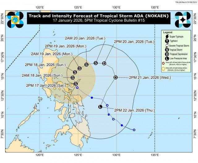
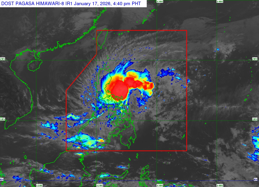
ADA was last spotted over the coastal waters of Pandan, Catanduanes (14.3°N, 124.4°E) packing maximum sustained winds of 85 km/h near the center, gustiness of up to 105 km/h, and central pressure of 994 hPa.
PAGASA said Ada may continue moving northwestward before slowly turning northward to northeastward by Sunday, but changes in the forecast track may cause a landfall scenario over Catanduanes.
"ADA is forecast to remain as a tropical storm while moving over the sea east of Luzon. However, further intensification to severe tropical storm is not ruled out," PAGASA said.
"This tropical cyclone will then weaken into a tropical depression by Tuesday (20 January) afternoon or evening due to the effects of the surge of the northeast monsoon," it added. —VAL, GMA Integrated News
