

10 areas under Signal No. 2 as Basyang threatens Surigao del Sur
Tropical Cyclone Wind Signal No. 2 is in effect over 10 areas in Mindanao as Tropical Storm Basyang is expected to make landfall over Surigao del Sur, state weather bureau PAGASA said on Thursday.
In its 8 a.m. bulletin, PAGASA raised the following storm signals:
Signal No. 2
Mindanao
- Surigao del Norte including Siargao - Bucas Grande Islands
- Surigao del Sur
- the extreme northern portion of Davao Oriental (Boston)
- Agusan del Norte
- Agusan del Sur
- Misamis Oriental
- the northern portion of Bukidnon (Impasug-Ong, Manolo Fortich, Malitbog, Sumilao, Libona, Baungon, City of Malaybalay, Cabanglasan)
- the northeastern portion of Lanao del Norte (Iligan City)
- the northeastern portion of Misamis Occidental (Baliangao, Plaridel, Lopez Jaena, Oroquieta City, Calamba, Aloran, Panaon)
- Camiguin
Signal No. 1
Luzon
- Cuyo Islands
Visayas
- the southern portion of Eastern Samar (Guiuan, Salcedo, Mercedes, Giporlos, Balangiga, Lawaan, Quinapondan, General Macarthur, Hernani, Llorente, Balangkayan)
- the southern portion of Samar (Marabut, Basey, Santa Rita)
- Biliran
- Leyte
- Southern Leyte
- Bohol
- Cebu
- Siquijor
- Negros Oriental
- Negros Occidental
- Guimaras
- Iloilo
- Capiz
- Aklan
- Antique
Mindanao
- Dinagat Islands
- the northern and central portions of Davao Oriental (Cateel, Baganga, Caraga, Manay, Tarragona, Lupon, Banaybanay)
- Davao de Oro
- Davao del Norte
- the northern portion of Davao del Sur (Davao City)
- the rest of Bukidnon
- the northern portion of Cotabato (Carmen, Banisilan, Alamada, President Roxas, Antipas, Arakan, Magpet, Matalam, Kabacan)
- Lanao del Sur
- the northern portion of Maguindanao del Norte (Buldon, Barira, Matanog)
- the rest of Lanao del Norte
- the rest of Misamis Occidental
- the eastern and central portions of Zamboanga del Norte (Mutia, Piñan, Polanco, Dipolog City, Dapitan City, Sibutad, Rizal, La Libertad, Labason, Kalawit, Liloy, Salug, Bacungan, Sindangan, Jose Dalman, Manukan, Pres. Manuel A. Roxas, Katipunan, Sergio Osmeña Sr., Siayan, Godod, Tampilisan, Gutalac)
- the northern and central portions of Zamboanga del Sur (Bayog, Kumalarang, Lapuyan, San Miguel, Guipos, Dinas, San Pablo, Dumalinao, Pagadian City, Tigbao, Lakewood, Dumingag, Mahayag, Molave, Josefina, Tambulig, Aurora, Ramon Magsaysay, Sominot, Midsalip, Labangan, Tukuran)
- the northern portion of Zamboanga Sibugay (Kabasalan, Diplahan, Naga, Titay, Ipil, Buug)
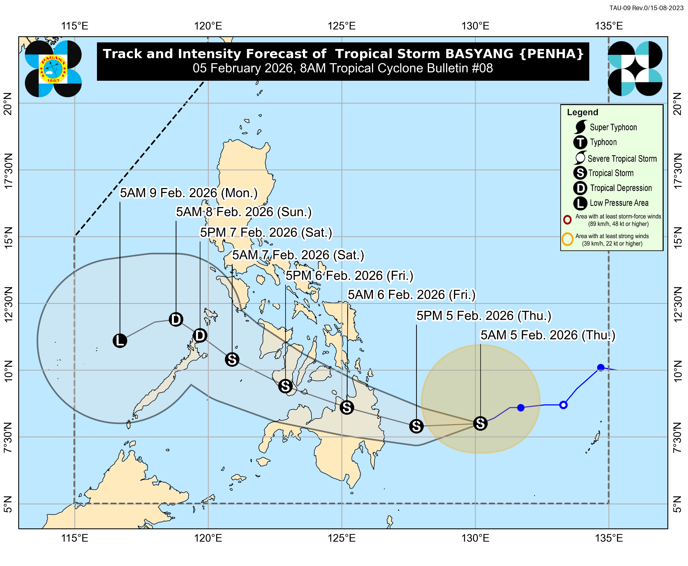
Basyang was last spotted 385 kilometers east of Hinatuan, Surigao del Sur with maximum sustained winds of 65 km per hour (kph) near the center and gustiness of up to 80 kph.
The tropical storm was moving west southwestward at 20 kph.
“On the forecast track, the center of BASYANG will make its initial landfall over Surigao del Sur between tonight and tomorrow early morning,” PAGASA said.
“BASYANG may further intensify prior to its initial landfall. It will then slightly weaken as it interacts with the landmass but it will likely remain a tropical storm. Further weakening into a tropical depression is forecast by Saturday and will be downgraded into a low pressure area by Monday (09 February),” it added.
Classes have been suspended in some areas on Thursday, February 5, 2026, due to inclement weather from Tropical Depression Basyang.
Meanwhile, the local government of Hinatuan, Surigao del Sur has begun enforcing preemptive evacuations in preparation for the effects of Tropical Depression Basyang. —VAL, GMA Integrated News
