

14 areas under Signal No. 2 as Basyang accelerates towards eastern Mindanao
Signal No. 2 was hoisted over 14 areas in Visayas and Mindanao as Tropical Storm Basyang (international name: Penha) continues to move closer towards eastern Mindanao.
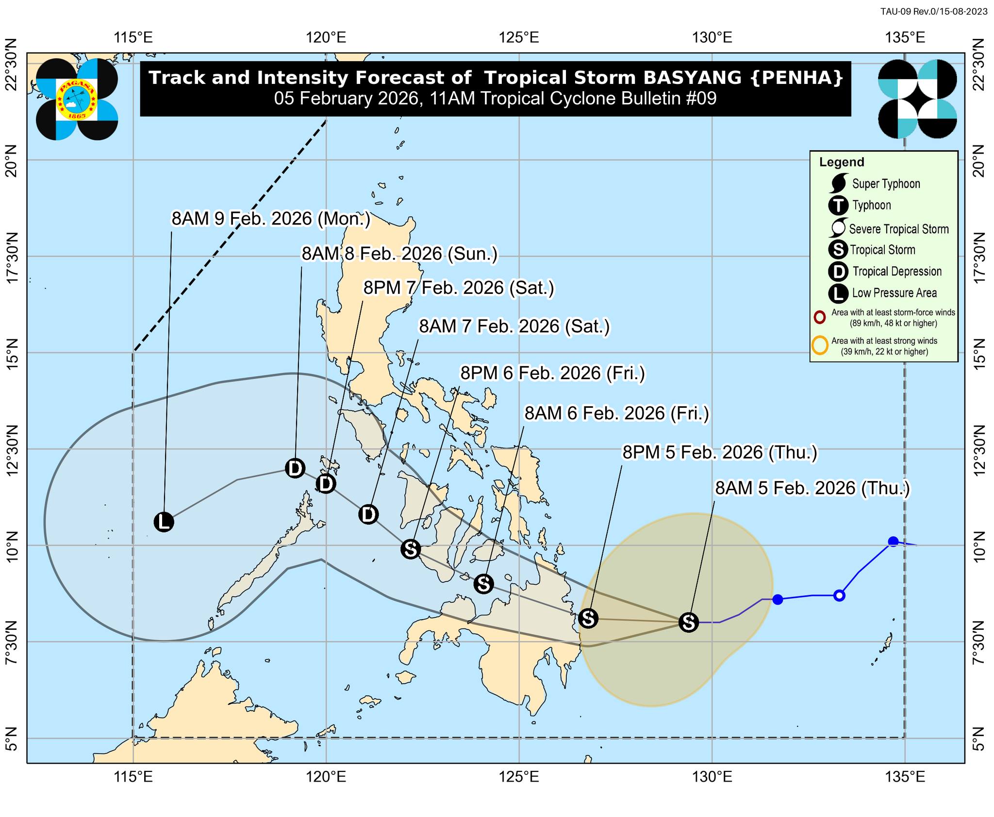
According to PAGASA's tropical cyclone bulletin at 11 a.m. Thursday, Basyang's eye was located 295 kms east of Hinatuan, Surigao del Sur.
The tropical storm carried maximum sustained winds of 65 kph near the center and a gustiness of up to 80 kph. It also had strong to gale-force winds extending outwards up to 300 kilometers from its eye.
Areas under Signal No. 2 will have gale-force winds of 62 kph to 88 kph within 24 hours. These areas are:
- Siquijor
- Southeastern portion of Negros Oriental (Dumaguete City, San Jose, Valencia, Bacong, Amlan, Dauin, Sibulan, Zamboanguita)
- Southern portion of Cebu (Samboan, Malabuyoc, Oslob, Ginatilan, Alegria, Dalaguete, Boljoon, Alcoy, Santander, Argao, Badian)
- Southern portion of Bohol (Bilar, Guindulman, Antequera, Sevilla, Loboc, Tagbilaran City, Maribojoc, Pilar, Jagna, Lila, Corella, Loon, Dimiao, Candijay, Alburquerque, Anda, Dauis, Sikatuna, Baclayon, Batuan, Loay, Valencia, Garcia Hernandez, Carmen, Panglao, Duero, Cortes, Balilihan, Sierra Bullones, Catigbian, San Isidro, Calape, Mabini, Alicia)
- Surigao del Norte including Siargao - Bucas Grande Islands
- Surigao del Sur
- Extreme northern portion of Davao Oriental (Boston)
- Agusan del Norte
- Agusan del Sur
- Misamis Oriental
- Northern portion of Bukidnon (Impasug-Ong, Manolo Fortich, Malitbog, Sumilao, Libona, Baungon, City of Malaybalay, Cabanglasan)
- Northeastern portion of Lanao del Norte (Iligan City)
- Northeastern portion of Misamis Occidental (Baliangao, Plaridel, Lopez Jaena, Oroquieta City, Calamba, Aloran, Panaon)
- Camiguin
Meanwhile, the following areas were placed under Signal No. 1 as winds of 39 kph to 61 kph are expected within 36 hours:
- Southern portion of Eastern Samar (Guiuan, Salcedo, Mercedes, Giporlos, Balangiga, Lawaan, Quinapondan, General Macarthur, Hernani, Llorente, Balangkayan)
- Southern portion of Samar (Marabut, Basey, Santa Rita)
- Biliran
- Leyte
- Southern Leyte
- The rest of Bohol
- The rest of Cebu
- The rest of Negros Oriental
- Negros Occidental
- Guimaras
- Iloilo
- Capiz
- Aklan
- Antique
- Dinagat Islands
- Northern and central portions of Davao Oriental (Cateel, Baganga, Caraga, Manay, Tarragona, Lupon, Banaybanay)
- Davao de Oro
- Davao del Norte
- Northern portion of Davao del Sur (Davao City)
- The rest of Bukidnon
- Northern portion of Cotabato (Carmen, Banisilan, Alamada, President Roxas, Antipas, Arakan, Magpet, Matalam, Kabacan)
- Lanao del Sur
- Northern portion of Maguindanao del Norte (Buldon, Barira, Matanog)
- The rest of Lanao del Norte
- The rest of Misamis Occidental
- Eastern and central portions of Zamboanga del Norte (Mutia, Piñan, Polanco, Dipolog City, Dapitan City, Sibutad, Rizal, La Libertad, Labason, Kalawit, Liloy, Salug, Bacungan, Sindangan, Jose Dalman, Manukan, Pres. Manuel A. Roxas, Katipunan, Sergio Osmeña Sr., Siayan, Godod, Tampilisan, Gutalac)
- Northern and central portions of Zamboanga del Sur (Bayog, Kumalarang, Lapuyan, San Miguel, Guipos, Dinas, San Pablo, Dumalinao, Pagadian City, Tigbao, Lakewood, Dumingag, Mahayag, Molave, Josefina, Tambulig, Aurora, Ramon Magsaysay, Sominot, Midsalip, Labangan, Tukuran)
- Northern portion of Zamboanga Sibugay (Kabasalan, Diplahan, Naga, Titay, Ipil, Buug)
The surge of the Northeast Monsoon was expected to bring strong to gale-force gusts over some areas in the country, while a gale warning was in effect over the eastern seaboard of Visayas and Mindanao.
"It must be emphasized that heavy rainfall and severe winds may still be experienced in localities outside the landfall point and the forecast confidence cone," PAGASA shared.
PAGASA predicted that Basyang will continue westward and make initial landfall over Surigao del Sur sometime on Thursday night before shifting west northwestward by Friday morning.
A close encounter or another landfall may occur over Siquijor and the southern portion of Negros Oriental by Friday afternoon.
PAGASA said Basyang may continue to intensify and weaken during the forecast period, but is likely to remain a tropical storm. — VDV, GMA Integrated News
