

Basyang maintains strength as 14 areas now under Signal No. 2
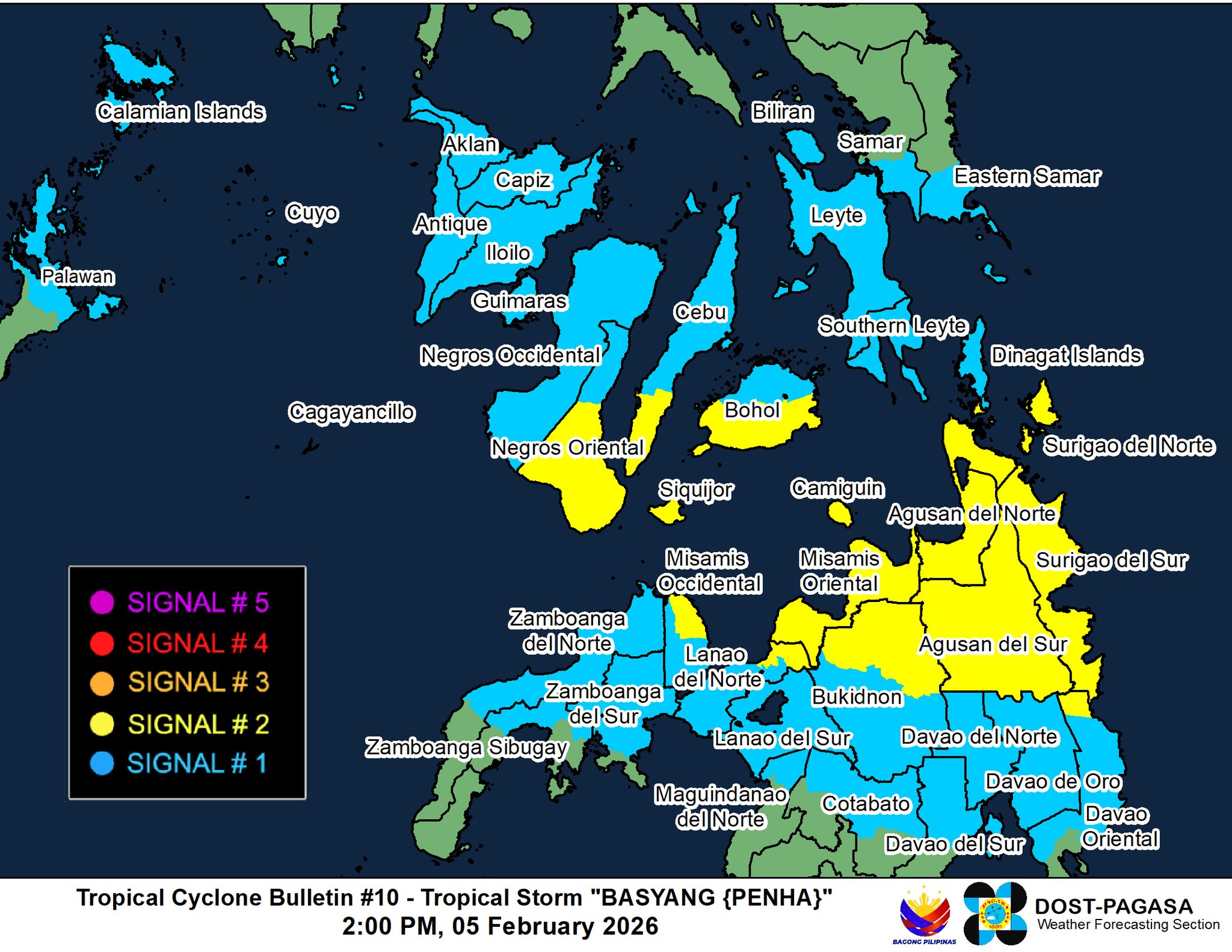
Tropical Storm Basyang has maintained its strength with 14 areas in Visayas and Mindanao were placed under Signal No. 2, the state weather bureau said on Thursday afternoon.
According to PAGASA’s 2 p.m. tropical cyclone update, the following wind signals are in effect:
Tropical Cyclone Wind Signal No. 2
Visayas
- Siquijor,
- The southern portion of Negros Oriental (Dumaguete City, San Jose, Valencia, Bacong, Amlan, Dauin, Sibulan, Zamboanguita, Siaton, City of Tanjay, Pamplona, Santa Catalina, Bais City, Manjuyod, Bindoy, City of Bayawan, Basay, Mabinay, Ayungon),
- The southern portion of Cebu (Samboan, Malabuyoc, Oslob, Ginatilan, Alegria, Dalaguete, Boljoon, Alcoy, Santander, Argao, Badian, Moalboal), and
- The southern portion of Bohol (Bilar, Guindulman, Antequera, Sevilla, Loboc, Tagbilaran City, Maribojoc, Pilar, Jagna, Lila, Corella, Loon, Dimiao, Candijay, Alburquerque, Anda, Dauis, Sikatuna, Baclayon, Batuan, Loay, Valencia, Garcia Hernandez, Carmen, Panglao, Duero, Cortes, Balilihan, Sierra Bullones, Catigbian, San Isidro, Calape, Mabini, Alicia)
Mindanao
- Surigao del Norte including Siargao - Bucas Grande Islands,
- Surigao del Sur,
- The extreme northern portion of Davao Oriental (Boston),
- Agusan del Norte,
- Agusan del Sur,
- Misamis Oriental,
- The northern portion of Bukidnon (Impasug-Ong, Manolo Fortich, Malitbog, Sumilao, Libona, Baungon, City of Malaybalay, Cabanglasan),
- The northeastern portion of Lanao del Norte (Iligan City),
- The northeastern portion of Misamis Occidental (Baliangao, Plaridel, Lopez Jaena, Oroquieta City, Calamba, Aloran, Panaon), and
- Camiguin
Tropical Cyclone Wind Signal No. 1
Luzon
- The northern portion of Palawan (Taytay, El Nido, Dumaran, Araceli) including Calamian, Cuyo, and Cagayancilo Islands
Visayas
- The southern portion of Eastern Samar (Guiuan, Salcedo, Mercedes, Giporlos, Balangiga, Lawaan, Quinapondan, General Macarthur, Hernani, Llorente, Balangkayan),
- The southern portion of Samar (Marabut, Basey, Santa Rita),
- Biliran,
- Leyte,
- Southern Leyte,
- The rest of Bohol,
- The rest of Cebu,
- The rest of Negros Oriental,
- Negros Occidental,
- Guimaras,
- Iloilo,
- Capiz,
- Aklan, and
- Antique
Mindanao
- Dinagat Islands,
- The northern and central portions of Davao Oriental (Cateel, Baganga, Caraga, Manay, Tarragona, Lupon, Banaybanay),
- Davao de Oro,
- Davao del Norte,
- The northern portion of Davao del Sur (Davao City),
- The rest of Bukidnon,
- The northern portion of Cotabato (Carmen, Banisilan, Alamada, President Roxas, Antipas, Arakan, Magpet, Matalam, Kabacan),
- Lanao del Sur,
- The northern portion of Maguindanao del Norte (Buldon, Barira, Matanog),
- The rest of Lanao del Norte,
- The rest of Misamis Occidental,
- The eastern and central portions of Zamboanga del Norte (Mutia, Piñan, Polanco, Dipolog City, Dapitan City, Sibutad, Rizal, La Libertad, Labason, Kalawit, Liloy, Salug, Bacungan, Sindangan, Jose Dalman, Manukan, Pres. Manuel A. Roxas, Katipunan, Sergio Osmeña Sr., Siayan, Godod, Tampilisan, Gutalac),
- The northern and central portions of Zamboanga del Sur (Bayog, Kumalarang, Lapuyan, San Miguel, Guipos, Dinas, San Pablo, Dumalinao, Pagadian City, Tigbao, Lakewood, Dumingag, Mahayag, Molave, Josefina, Tambulig, Aurora, Ramon Magsaysay, Sominot, Midsalip, Labangan, Tukuran), and
- The northern portion of Zamboanga Sibugay (Kabasalan, Diplahan, Naga, Titay, Ipil, Buug).
Basyang was last spotted at 230 kilometers east of Hinatuan, Surigao del Sur and is packing maximum sustained winds of 65 kph and gustiness of up to 80 kph. It is moving westward at 25 km/h.
“The wind signals warn the public of the general wind threat over an area due to the tropical cyclone. Local winds may be slightly stronger/enhanced in coastal and upland/mountainous areas exposed to winds. Winds are less strong in areas sheltered from the prevailing wind direction,” PAGASA said.
A gale warning is also in effect over the northern seaboard of Mindanao and the eastern seaboards of Visayas and Mindanao.
“It must be emphasized that heavy rainfall and severe winds may still be experienced in localities outside the landfall point and the forecast confidence cone,” the state weather bureau said.
Basyang may make initial landfall over Surigao del Sur by Thursday night or Friday early morning, then move west northwestward by Friday morning.
It may pass close or make another landfall over Siquijor and the southern portion of Negros Oriental by Friday afternoon to evening.
Basyang may further intensify before landfall, then likely remain a tropical storm before weaking into a tropical depression by Saturday and eventually into a low pressure area (LPA) by Monday. — JMA, GMA Integrated News
