

Signal No. 2 up in 13 areas as Basyang slightly intensifies
State weather bureau PAGASA said Signal No. 2 was in effect over 13 areas in Visayas and Mindanao as Tropical Storm Basyang (international name: Penha) slightly intensified in its approach towards eastern Mindanao, PAGASA said late Thursday afternoon.
In its 5 p.m. weather bulletin, PAGASA said the following areas were under Signal No. 2:
Visayas
- Siquijor
- Southern portion of Negros Oriental (Dumaguete City, San Jose, Valencia, Bacong, Amlan, Dauin, Sibulan, Zamboanguita, Siaton, City of Tanjay, Pamplona, Santa Catalina, Bais City, Manjuyod, Bindoy, City of Bayawan, Basay, Mabinay, Ayungon, Tayasan, Jimalalud, La Libertad)
- Southern portion of Negros Occidental (Candoni, City of Sipalay, Ilog, City of Kabankalan, Cauayan, Hinoba-An, City of Himamaylan, Binalbagan)
- Southern portion of Cebu (Samboan, Malabuyoc, Oslob, Ginatilan, Alegria, Dalaguete, Boljoon, Alcoy, Santander, Argao, Badian, Moalboal, Ronda, Alcantara, Sibonga, Dumanjug)
- Southern portion of Bohol (Bilar, Guindulman, Antequera, Sevilla, Loboc, Tagbilaran City, Maribojoc, Pilar, Jagna, Lila, Corella, Loon, Dimiao, Candijay, Alburquerque, Anda, Dauis, Sikatuna, Baclayon, Batuan, Loay, Valencia, Garcia Hernandez, Carmen, Panglao, Duero, Cortes, Balilihan, Sierra Bullones, Catigbian, San Isidro, Calape, Mabini, Alicia, Tubigon, Sagbayan, Clarin)
Mindanao
- Surigao del Norte including Siargao - Bucas Grande Islands, Surigao del Sur, the extreme northern portion of Davao Oriental (Boston)
- Agusan del Norte
- Agusan del Sur
- Misamis Oriental
- Northern portion of Bukidnon (Impasug-Ong, Manolo Fortich, Malitbog, Sumilao, Libona, Baungon, City of Malaybalay, Cabanglasan)
- Northeastern portion of Lanao del Norte (Iligan City)
- Northeastern portion of Misamis Occidental (Baliangao, Plaridel, Lopez Jaena, Oroquieta City, Calamba, Aloran, Panaon)
- Camiguin
Signal No. 1, meanwhile, was hoisted over the following areas:
Luzon
- Southern portion of Occidental Mindoro (San Jose, Magsaysay, Rizal, Calintaan)
- Southern portion of Oriental Mindoro (Mansalay, Bulalacao)
- Southern portion of Romblon (Ferrol, Looc, Alcantara, Santa Fe, San Jose)
- Northern portion of Palawan (Taytay, El Nido, Dumaran, Araceli) including Calamian, Cuyo, and Cagayancilo Islands
Visayas
- Southern portion of Eastern Samar (Guiuan, Salcedo, Mercedes, Giporlos, Balangiga, Lawaan, Quinapondan, General Macarthur, Hernani, Llorente, Balangkayan)
- Southern portion of Samar (Marabut, Basey, Santa Rita)
- Biliran
- Leyte
- Southern Leyte
- The rest of Bohol
- The rest of Cebu
- The rest of Negros Oriental
- The rest of Negros Occidental
- Guimaras
- Iloilo
- Capiz
- Aklan
- Antique
Mindanao
- Dinagat Islands
- Northern and central portions of Davao Oriental (Cateel, Baganga, Caraga, Manay, Tarragona, Lupon, Banaybanay)
- Davao de Oro
- Davao del Norte
- Northern portion of Davao del Sur (Davao City)
- The rest of Bukidnon
- Northern portion of Cotabato (Carmen, Banisilan, Alamada, President Roxas, Antipas, Arakan, Magpet, Matalam, Kabacan)
- Lanao del Sur
- Northern portion of Maguindanao del Norte (Buldon, Barira, Matanog)
- The rest of Lanao del Norte
- The rest of Misamis Occidental
- Eastern and central portions of Zamboanga del Norte (Mutia, Piñan, Polanco, Dipolog City, Dapitan City, Sibutad, Rizal, La Libertad, Labason, Kalawit, Liloy, Salug, Bacungan, Sindangan, Jose Dalman, Manukan, Pres. Manuel A. Roxas, Katipunan, Sergio Osmeña Sr., Siayan, Godod, Tampilisan, Gutalac)
- Northern and central portions of Zamboanga del Sur (Bayog, Kumalarang, Lapuyan, San Miguel, Guipos, Dinas, San Pablo, Dumalinao, Pagadian City, Tigbao, Lakewood, Dumingag, Mahayag, Molave, Josefina, Tambulig, Aurora, Ramon Magsaysay, Sominot, Midsalip, Labangan, Tukuran)
- Northern portion of Zamboanga Sibugay (Kabasalan, Diplahan, Naga, Titay, Ipil, Buug)
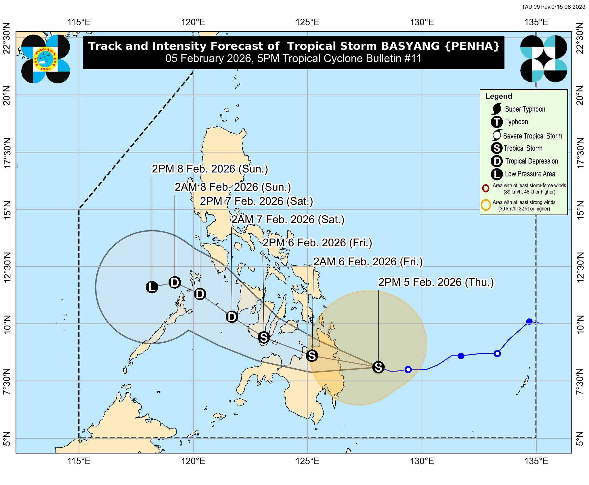
At 4 p.m. today (Thursday), Basyang was located 150 kms east of Hinatuan, Surigao del Sur. It was carrying maximum sustained winds of 75 kph near the center, gusts of up to 90 kph, and was moving west northwestward at 25 kph.
PAGASA said minimal to minor impact from strong winds may occur in areas under Wind Signal No. 1, while minor to moderate impact from gale-force winds may persist in areas under Wind Signal No. 2.
"It must be emphasized that heavy rainfall and severe winds may still be experienced in localities outside the landfall point and the forecast confidence cone," the state weather bureau said.
The surge of the Northeast Monsoon will also bring strong to gale-force gusts over Batanes, Babuyan Islands, Ilocos Norte, Apayao, Abra, Northern portion of Mainland Cagayan, Eastern portion of Isabela, Most of Central Luzon, Metro Manila, CALABARZON, Bicol Region, Most of MIMAROPA, Central Visayas, Eastern Visayas, Dinagat Islands, Siargao and Bucas Grande Islands, Surigao del Norte, Surigao del Sur, Agusan del Norte, Misamis Oriental, Lanao del Norte, Lanao del Sur, Bukidnon, Misamis Occidental, Zamboanga Peninsula, southern portion of SOCCSKSARGEN, Davao de Oro, Davao del Norte, and Davao Oriental on Friday.
A minimal to moderate risk of storm surge with peak heights reaching up to 2.0 m is expected within the next 48 hours over low-lying or exposed coastal communities of Occidental Mindoro. Oriental Mindoro, Romblon, Palawan, including Calamian, Cuyo, and Cagayancillo islands, Antique, AKlan, Capiz, Iloilo, Guimaras, Negros Occidental, Negros Oriental, Cebu, Bohol, Guimaras, Siquijor, Southern Leyte, Leyte, Camiguin, Dinagat Islands, Siargao and Bucas Grande Islands, Surigao del Norte, Surigao del Sur, Davao Oriental, Agusan del Norte, Misamis Oriental, Lanao del Norte and Misamis Occidental.
A gale warning was also in effect over the eastern and central seaboards of Visayas and the northern and eastern seaboards of Mindanao.
PAGASA said Basyang was temporarily moving west northwestward but may still move westward for the next 12 hours before turning west northwestward beginning Friday morning.
Basyang was expected to make initial landfall over Surigao del Sur Thursday evening or early Friday morning.
"After crossing Mindanao, it is likely to emerge over Bohol Sea tomorrow morning, and may pass close or make another landfall over Siquijor and the southern portion of Negros Oriental by tomorrow afternoon to evening," PAGASA said.
"By tomorrow evening or Saturday (07 February) early morning, it will emerge over Sulu Sea, then traverse the northern portion of Palawan between Saturday afternoon and evening," it added.
The storm may further intensify prior to its initial landfall and slightly weaken as it interacts with the landmass.
PAGASA said Basyang will likely remain a tropical storm.
"Further weakening into a tropical depression is forecast by Saturday and will be downgraded into a low pressure area by Sunday (08 February) afternoon or evening," PAGASA said. — VDV, GMA Integrated News
