

 GMA Brandtalk
 Tracking
 Archives

LPA trough to bring rains over Eastern Mindanao - PAGASA
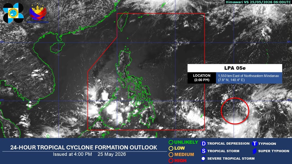
The trough of the low pressure area (LPA) being monitored outside the Philippine Area of Responsibility is expected to dampen the eastern section of Mindanao, the state weather bureau PAGASA said.
According to its 24-hour-weather forecast issued at 4 p.m. on Monday, the trough might bring cloudy skies with scattered rains and thunderstorms over the said portion of Mindanao.
PAGASA said the LPA was last monitored 1,550 kilometers east of northeastern Mindanao as of 2 p.m. It noted that it has a high chance of developing into a tropical depression within the next 24 hours.
Meanwhile, the southwesterly windflow is expected to bring cloudy skies with scattered rains and thunderstorms over Zamboanga Peninsula, BARMM, SOCCSKSARGEN, Lanao del Norte, Misamis Occidental, and Palawan.
The easterlies, on the other hand, might bring partly cloudy to cloudy skies with isolated rain showers or thunderstorms over Eastern Visayas, Bicol Region, and Quezon Province.
Furthermore, localized thunderstorms are expected to bring partly cloudy to cloudy skies with isolated rain showers or thunderstorms over Metro Manila and the rest of the country.
PAGASA warned of possible flash floods or landslides over the abovementioned areas during heavy rains or severe thunderstorms.
The maximum temperature recorded, based on data from the PAGASA Weather Station in Science Garden, Diliman, Quezon City, reached 35.6°C at 3 p.m.., while the minimum dropped to 27.3°C at 5 a.m.
Moreover, the sunset is expected at 6:20 p.m. today, while the sunrise on Tuesday is expected at 5:26 a.m. —Vince Angelo Ferreras/RF, GMA News

