

Francisco nearing super typhoon category —PAGASA
Typhoon Francisco is forecast to reach super typhoon category within the next 12 hours, the state weather bureau PAGASA said.
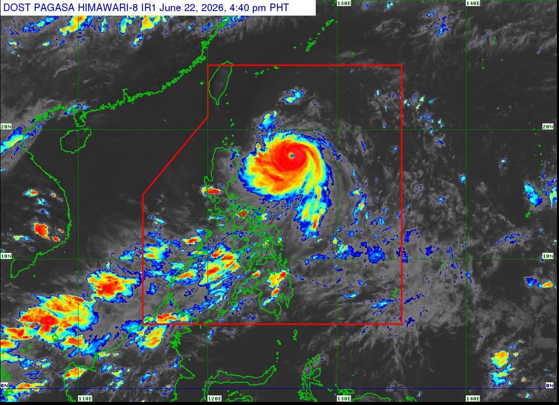
According to the 5 p.m. bulletin, the center of the eye of the typhoon was last monitored 625 kilometers east of Tuguegarao City, Cagayan. It packs maximum sustained winds of 175 kilometers per hour near the center, and gustiness of up to 215 kilometers per hour.
Tropical Cyclone Wind Signal No. 1 is hoisted over the following:
- Batanes
- The northeastern portion of Cagayan (Gonzaga, Santa Ana) including the eastern portion of Babuyan Islands (Babuyan Is., Didicas Is., Camiguin Is.,)
Based on the heavy rainfall outlook, 50 to 100 millimeters of rainfall is expected over Batanes and Cagayan from Tuesday afternoon, June 23 to Wednesday afternoon, June 24.
PAGASA warned of possible localized flooding mainly in urbanized or low-lying areas. Landslides are also possible in highly susceptible areas.
Meanwhile, minimal to minor impacts from strong winds are possible within any of the areas under Wind Signal No. 1.
The state weather bureau said that the Southwest Monsoon, or Habagat, and the periphery of Typhoon Francisco will bring strong to gale-force gusts over the following areas (especially in coastal and upland areas exposed to winds):
Monday, June 22: Most of Luzon, most of Visayas, Zamboanga Peninsula, Misamis Occidental, Lanao del Norte, Camiguin, Surigao del Norte, Dinagat Islands, Davao Occidental, and Davao Oriental.
Tuesday, June 23: Most of Luzon, Visayas, Zamboanga Peninsula, Northern Mindanao, Surigao del Norte, Dinagat Islands, Davao Occidental, and Davao Oriental.
Wednesday, June 24: Most of Luzon, Visayas, Misamis Occidental, Lanao del Norte, Camiguin, Dinagat Islands, Davao Occidental, and Davao Oriental.
PAGASA said that Francisco is expected to move generally northwestward until Tuesday and will decelerate before recurving north northeastward towards the Ryukyu Islands in southern Japan.
Francisco is forecast to exit the Philippine Area of Responsibility on Friday, June 26, said PAGASA.
Although this weather disturbance will remain far from the Philippine landmass, PAGASA said a slight westward shift in the track forecast is still possible. —LDF, GMA News
