

Super Typhoon Francisco prompts Signal No. 1 in parts of extreme Northern Luzon
Francisco (international name: Mekkhala) has now intensified into a super typhoon with Signal No. 1 raised over parts of Extreme Northern Luzon, the state weather bureau said late Monday night.
In its 11 p.m. tropical cyclone bulletin, PAGASA said Signal No. 1 is in effect in the following areas:
- Batanes, and
- The northeastern portion of Cagayan (Gonzaga, Santa Ana) including the eastern portion of Babuyan Islands (Babuyan Is., Didicas Is., Camiguin Is.,)
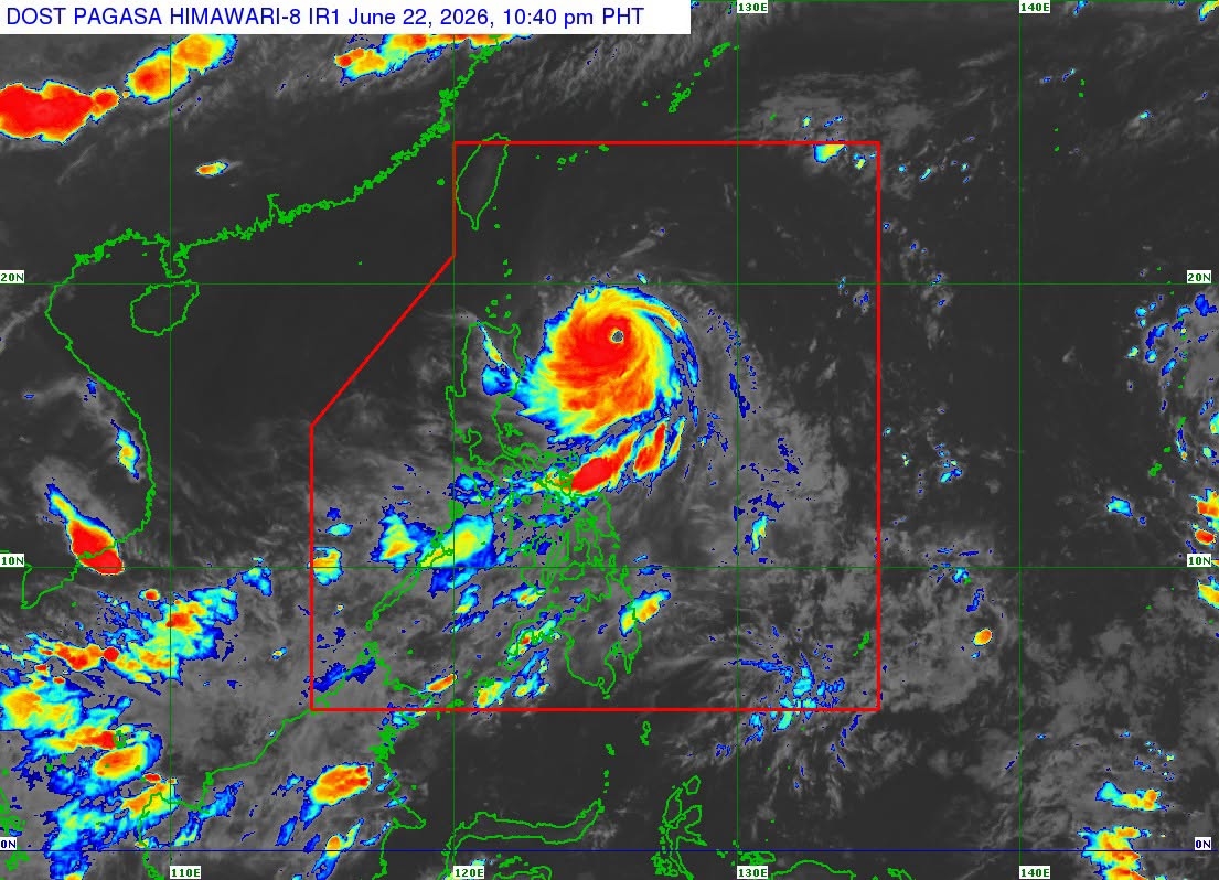
As of 10 p.m., Super Typhoon Francisco was estimated to be 44 km east of Tuguegarao City, Cagayan or 450 km east of Aparri, Cagayan.
It is packing maximum sustained winds of 185 km/h near the center with gustiness of up to 230 km/h, and central pressure of 940 hPa.
Francisco is moving west northwestward at 15 km/h, with its strong to typhoon-force winds extending outwards up to 360 km from the center.
The state weather bureau said the highest wind signal that may be hoisted during the passage of the super typhoon is Signal No. 2, “should there be a westward shift in the forecast track.”
“Francisco is forecast to gradually decelerate while moving generally northwestward until tomorrow (23 June) before recurving towards the Ryukyu Islands in southern Japan,” PAGASA said.
It is also expected to intensify and may reach peak intensity within the next 12 hours, after which a weakening trend is expected due to increasingly unfavorable environmental conditions.
The super typhoon will exit the Philippine Area of Responsibility (PAR) on Friday, June 26.
“This tropical cyclone will remain far from the Philippine landmass. However, slight westward shift in the track forecast is still possible,” PAGASA said.
Meanwhile, the Southwest Monsoon or Habagat and the periphery of Francisco will bring strong to gale-force gusts over the following areas:
Monday, June 22:
- Most of Luzon
- Most of Visayas
- Zamboanga Peninsula
- Misamis Occidental
- Lanao del Norte
- Camiguin
- Surigao del Norte
- Dinagat Islands
- Davao Occidental, and
- Davao Oriental.
Tuesday, June 23:
- Most of Luzon
- Visayas
- Zamboanga Peninsula
- Northern Mindanao
- Surigao del Norte
- Dinagat Islands,
- Davao Occidental, and
- Davao Oriental.
PAGASA also warned mariners of rough seas of up to 4 meters in the eastern seaboards of Batanes and Babuyan Islands; up to 3.5 meters in the northeastern seaboard of mainland Cagayan, and up to 3 meters over the remaining seaboards of mainland Cagayan, the eastern seaboards of Isabela and northern Aurora, the remaining seaboards of Batanes, Babuyan Islands, and mainland Cagayan.
“Mariners of small seacrafts, including all types of motorbancas, are advised not to venture out to sea under these conditions, especially if inexperienced or operating ill-equipped vessels,” the state weather bureau added. — JMA, GMA News
