

 GMA Brandtalk
 Tracking
 Archives

Typhoon Inday maintains strength; Batanes, parts of Cagayan under Signal No. 2
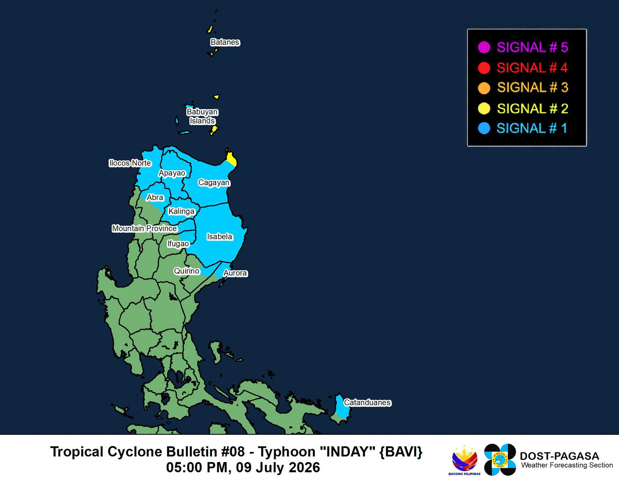
Typhoon Inday maintained its strength as it continued moving west northwestward over the waters east of Northern Luzon, PAGASA said Thursday afternoon.
As of 4 p.m., the center of Inday was located 780 kilometers east of Aparri, Cagayan. The typhoon had maximum sustained winds of 165 km/h near the center and gustiness of up to 205 km/h, while moving west northwestward at 20 km/h.
Tropical Cyclone Wind Signal No. 2 was raised over Batanes, the eastern portion of Babuyan Islands (Babuyan Is., Didicas Is., Camiguin Is.) and the northeasternmost portion of mainland Cagayan (Santa Ana).
Under Signal No. 1 are the following areas:
- the rest of Cagayan, including the rest of Babuyan Islands
- Isabela
- the northeastern portion of Quirino (Maddela)
- Apayao
- the northern portion of Abra (Tineg, Lagayan, Danglas, San Juan, Lagangilang, Licuan-Baay, Malibcong, Lacub, Daguioman, Dolores, La Paz)
- Kalinga
- the eastern portion of Mountain Province (Natonin, Paracelis)
- the eastern portion of Ifugao (Aguinaldo, Alfonso Lista)
- Ilocos Norte
- the northern portion of Aurora (Dilasag, Casiguran)
- the northern and central portions of Catanduanes (Pandan, Caramoran, Bagamanoc, Panganiban, Viga, Gigmoto, Baras, San Miguel)
Both Inday and the Southwest Monsoon (Habagat) will bring rains and strong winds to several parts of the country from Friday to Sunday, PAGASA said.
Inday is forecast to pass closest to extreme Northern Luzon between Friday evening and Saturday morning. It will then move toward the southern islands of Japan and may make landfall over or pass close to the northern coast of Taiwan.
The typhoon is expected to exit the Philippine Area of Responsibility (PAR) by Saturday morning or afternoon and make landfall along the eastern coast of mainland China by Saturday evening or early Sunday morning.
"Inday is forecast to remain as a typhoon until it exits the PAR. It will then weaken into a severe tropical storm after moving further inland over mainland China," PAGASA said. — VBL, GMA News

