

 GMA Brandtalk
 Tracking
 Archives

Typhoon Saudel to enter PAR on Monday, will be called Obet
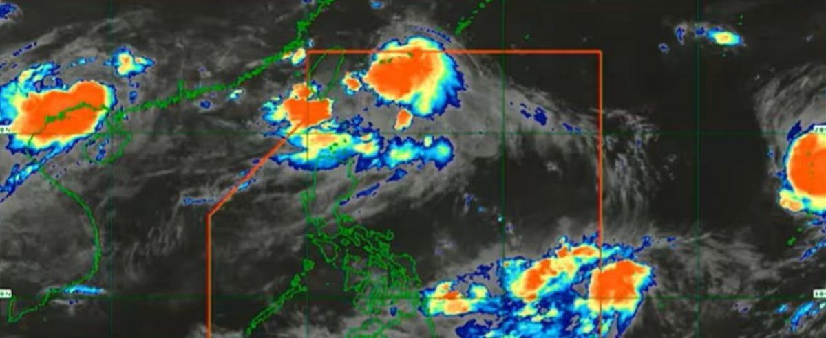
Typhoon Saudel which is outside the Philippine Area of Responsibility on Saturday is expected to enter PAR on Monday and will then be called Obet, PAGASA said on Saturday.
The weather bureau said Saudel may possibly enter PAR on Monday morning or afternoon.
"'Yung isa sa reason kung bakit magiging maulap na sa pagpasok ng susunod na linggo ay dahil dito sa isang bagyo na nasa labas ng PAR. Typhoon category ito, may kalakasan at may international name na Saudel at ito ang posibleng pumasok ng PAR by Monday morning or afternoon. So by Monday, pagpasok ng PAR ito ay tatawaging Obet," PAGASA weather specialist John Manalo said in an interview on Super Radyo dzBB.
(One of the reasons why it will be cloudy this coming week is a tropical cyclone outside PAR. It's in the typhoon category, a bit strong, and with international name Saudel. It may possibly enter PAR by Monday morning or afternoon. So by Monday, when it enters PAR, it will be called Obet.)
At 2 a.m. Saturday, Saudel was estimated to be located at 2,725 km east of Northern Luzon, packing winds of 130 km/h and gustiness of 160 km/h. It is moving northwestward at 25 km/h.
Saudel is not expected to make landfall but will enhance the Southwest Monsoon or Habagat, he said.
"Kahit pumasok man ito, umangat ng konti o lumapit sa kalupaan, sobrang baba ang tsansa na mag-landfall ito. Pero ang certain tayo ay palalakasin nito ang Habagat," Manalo said.
(Even if it enters [PAR], goes up a bit or gets near the landmass, it has a very low chance of making landfall. But what we are certain of is that it will enhance the Habagat.)
Aside from Saudel, PAGASA is also monitoring a tropical depression which may also enter PAR. However, this may merge with Typhoon Saudel later on.
This tropical depression was estimated to be located at 1,220 km east of Northeastern Mindanao as of 2 a.m. It has winds of 45 km/h and gustiness of 55 km/h. The tropical depression is moving westward at 10 km/h.
"Kahit na may posibilidad na pumasok ng PAR...may tsansa na maging tropical storm ito, pero ang mangyayari, dahil mas malaking system ang Saudel, ang mangyayari ay sasakupin lang, sasama lang siya sa sirkulasyon ng Typhoon Saudel. Eventually malulusaw itong tropical depression," Manalo said.
(Even with the possibility of entering PAR...it has a chance of developing into a tropical storm, what will happen is that it will just become part of the larger system of Saudel. It will just be part of the circulation of Typhoon Saudel. Eventually, this tropical depression will dissipate.)
Rains
The chances of having rains this weekend is lesser, but will be higher starting Monday.
"Magiging maganda pa rin po, ibig sabihin less clouds and less chance of rain 'yung magiging panahon natin today. Bukas posible unti-unti na lalo na sa hapon na magkaroon ng mga kaulapan. Ito ay dahil sa isang bagyo na nasa labas ng PAR. Mas tataas ang tsansa ng mga pag-ulan sa Monday," Manalo said.
(The weather condition today will be fair, that means less clouds and less chance of rain. Tomorrow, it is possible to have some clouds especially in the afternoon. This is due to the typhoon outside PAR. There is a higher chance of rain on Monday.)
READ: Habagat to prevail over most of Luzon; 2 tropical cyclones outside PAR
"Unti-unti, padagdag nang padagdag 'yung mga kaulapan. So Tuesday, posible na hindi lang 'yung western section ng Northern Luzon and Central Luzon 'yung magiging maulap. Magiging kasama na rin dito 'yung Metro Manila, MIMAROPA, CALABARZON at ganu'n din, by Tuesday 'yung Western Visayas. At ganu'n din sa Wednesday and Thursday," he said.
(Slowly, there will be more and more clouds. On Tuesday, it is possible that it will be cloudy not just in Northern Luzon and Central Luzon but also in Metro Manila, MIMAROPA, CALABARZON, and by Tuesday too, Western Visayas. It will be the same on Wednesday and Thursday.)
Manalo said although Saudel will enhance the Southwest Monsoon or Habagat, the rains next week may not be as intense as those that were experienced last Monday in Metro Manila.
"Sa ating current assessment, hindi naman magiging kasing lakas nu'ng nangyari noong Monday although may enhancement ng Habagat. Pero nakadepende pa rin... Halimbawa, mas bumaba pa ang track ni Saudel, may potential na relatively malalakas din ang mga pag-ulan. At kapag mas umakyat naman, mas magiging bawas," he said.
(In our current assessment, the rains will not be as intense as last Monday although there is enhancement of the Habagat. But it depends. For example, if Saudel's track goes downward, there is potential for relatively heavy rains. And when the track goes upward, there will be lesser [rains].)
"Nakadepende doon sa hihilahin na moisture ng Typhoon Saudel 'yung magiging cloudiness na mararanasan natin next week," Manalo added.
(The cloudiness that we will experience next week would depend on the amount of moisture that will be taken in by Typhoon Saudel.)
He said it is possible that on Thursday, Habagat will still be dominant, but it all depends on the movement of Typhoon Saudel.
"Kapag mas bumagal siya (Saudel) at nag-stay sa northeastern part o kahit sa northern part ng ating bansa ay 'yung paghila niya ng Habagat ay mas masu-sustain. Pero kapag mas bumilis ang kanyang pagkilos, posible na by Thursday ay unti-unti nang hihina ito bago mag-weekend 'yung ating Habagat," Manalo said.
(If it [Saudel] slows down and stays in the northeastern part or even in the northern part of our country, its enhancement of the Habagat will be sustained. However, if it goes faster, it is possible that by Thursday, the Habagat will start to weaken before weekend.)
Hot in Visayas and Mindanao
Mindanao and Visayas however are experiencing hot weather now, he added.
"Yung Mindanao, mainit ang kanilang nararanasan. Doon naman sa Visayas, mainit. Ibig sabihin mataas na temperature 'yung nakakaapekto sa kanila sa kasalukuyan," Manalo said.
(Mindanao is experiencing hot weahter. In Visayas, it is hot. That means higher temperature is affecting them currently.)
"Pero good news, may naobserbahan na tayong mga pag-ulan dito sa Cebu at posibleng madagdagan 'yan 'pag lumapit na itong si Bagyong Saudel. Pero sa Mindanao, mainit talaga ang mararanasan natin at mababa ang tsansa ng mga pag-ulan," he added.
(But good news, we observed some rain in Cebu, and there may be more rain when Typhoon Saudel gets nearer. But in Mindanao, it would really be hot and there is a low chance of having rain.)
Fourth cyclone in August
Saudel will be the fourth tropical cyclone to enter PAR this August.
"Usual po ito. Ang forecast natin 'pag August — kasi August 'yung buwan na kung saan pinaka-dominant at pinakanakakaapekto sa atin ang Hanging Habagat — so two to four na bagyo 'pag August," Manalo said.
(This is usual. Our forecast for August — because August is the month where Habagat is the most dominant and affects us most — is two to four tropical cyclones.)
"Ang unusual dito, 'yung sobrang dami ng low pressure area na bigla-bigla na lang sumusulpot dahil na rin sa tinatawag natin na monsoonal inflow," he said.
(What's unusual here is that many low pressure areas form suddenly due to what we call the monsoonal inflow.)
Habagat, El Niño
Manalo said it is possible to have rains even during El Niño.
"Totally different ang Habagat at El Niño. 'Yung Habagat, talagang nararanasan natin taon-taon. 'Yan ay associated sa tinatawag natin na rainy season," he said.
(Habagat and El Niño are totally different. We experience Habagat every year; it is associated with the rainy season.)
"'Yung El Niño naman ay larger scale na may frequency or circulation or fluctuation na umaabot ng two to seven years. May mga taon na El Niño tulad ngayon. May mga taon na La Niña," Manalo said.
(The El Niño is on a larger scale with frequency or circulation or fluctuation that reaches two to seven years. So there are years with El Niño like now. There are years with La Niña.)
"Possible ba na tag-ulan tapos El Niño? Yes, posible po at 'yan ang nakakaapekto sa atin ngayon. And in fact, 'yung El Niño ay may kontribusyon kaya nararanasan ng mga kababayan natin sa Mindanao 'yung relatively higher than usual na mga temperature," he added.
(Is it possible to have rains during El Niño? Yes, it is possible, and that is what is affecting us now. And in fact, El Niño has a contribution to what our countrymen in Mindanao are experiencing now — the relatively higher than usual temperatures.) —KG, GMA News

