

 GMA Brandtalk
 Tracking
 Archives

3 tropical cyclones monitored near PAR; Saudel intensifies, may become super typhoon
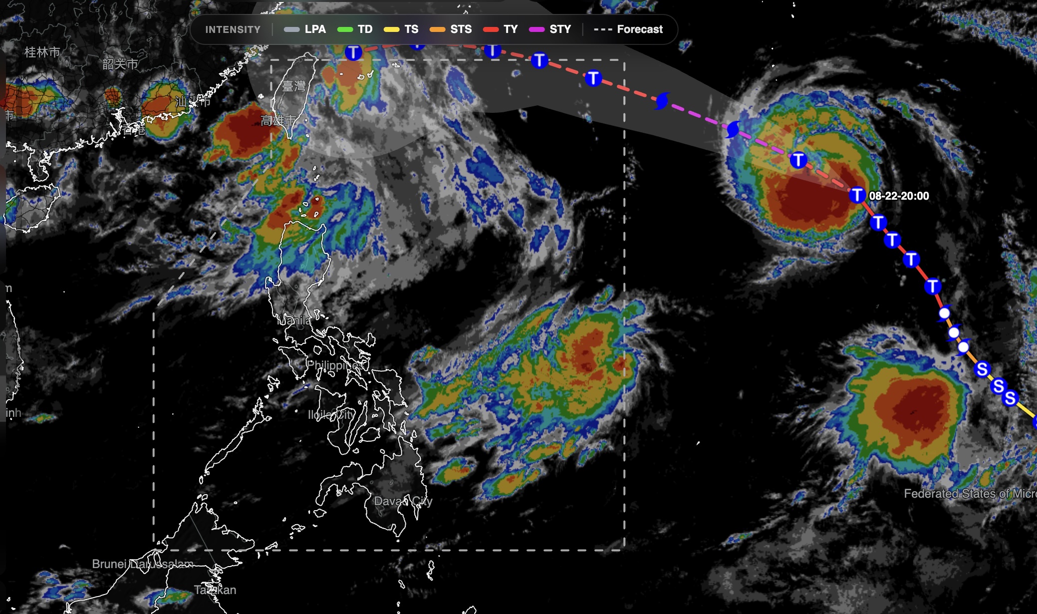
State weather bureau PAGASA is monitoring on Sunday three tropical cyclones outside the Philippine Area of Responsibility (PAR), including Typhoon Saudel, which has intensified, with maximum sustained winds of 175 kilometers per hour.
As of 3 a.m. Sunday, Saudel was located 2,245 kilometers east of extreme Northern Luzon and was moving west-northwestward at 25 kph.
It had maximum sustained winds of 175 kph near the center and gustiness of up to 215 kph, according to PAGASA's 4 a.m. weather bulletin.
Also being monitored was a tropical depression located 1,205 kilometers east of Eastern Visayas. It had maximum sustained winds of 55 kph and gustiness of up to 70 kph and was moving northwestward at 15 kph.
The third cyclone, Tropical Depression Gaenari, was located 565 kilometers north of Itbayat, Batanes. It was moving westward at 10 kph, with maximum sustained winds of 55 kph and gustiness of up to 70 kph.
All three cyclones remained outside the Philippine Area of Responsibility (PAR) as of 3 a.m. Sunday, with PAGASA yet to raise any tropical cyclone wind signal over the country.
Saudel
Based on PAGASA's Tropical Cyclone Advisory No. 1 for Typhoon Saudel issued at 11 p.m. on August 23, Typhoon Saudel is expected to become a super typhoon while outside PAR on Sunday night.
At 8 p.m. Sunday, Saudel may be at 1,845 km east of Extreme Northern Luzon, still outside PAR, with maximum sustained winds of 185 km/h (super typhoon category) and moving west northwest at 25 km/h.
On Monday morning at 8 a.m., Saudel is expected to be located at 1,550 km east northeast of Extreme Northern Luzon, still outside PAR, with maximum sustained winds of 185 km/h (super typhoon category) and moving at 30 km/h west northwest.
At 8 p.m. Monday, however, Saudel is seen to be inside PAR at 1,280 km east northeast of Extreme Northern Luzon packing maximum winds of 175 km/h (typhoon category) and with speed of 25/km/h as it moves west northwest.
PAGASA earlier said that once Saudel is inside PAR, it will be called Obet.
The state weather bureau also said that Saudel is expected to enhance the Southwest Monsoon (Habagat).
"Although no direct effect is seen, it is also possible that it will enhance the Southwest Monsoon again," said PAGASA weather specialist Veronica Torres in an interview with Super Radyo dzBB on Sunday.
With that, Torres said rainy weather is forecast over Metro Manila starting today.
Habagat
Meanwhile, the Southwest Monsoon (Habagat) is affecting Luzon, bringing occasional rains over Batanes and cloudy skies with scattered rains and thunderstorms over Metro Manila, the Ilocos Region, the Cordillera Administrative Region, Central Luzon, Rizal, Cavite, Batangas, Occidental Mindoro and the rest of Cagayan Valley.
PAGASA warned of possible flash floods and landslides in areas affected by moderate to at times heavy rains.
Batanes may have 50 to 100 mm of heavy rains today, PAGASA said in its heavy rainfall outlook.
The rest of Luzon and the rest of the country may experience partly cloudy to cloudy skies with isolated rainshowers or thunderstorms due to the southwest monsoon and localized thunderstorms, respectively.
The northern and western sections of Luzon may also experience moderate to strong winds and moderate to rough coastal waters, with wave heights of 1.5 to 3.4 meters.
Sunrise is expected at 5:45 a.m., while sunset will be at 5:35 p.m. —with a report from Vince Angelo Ferreras/MCG/KG, GMA News

