

LIST: Strong earthquakes that struck Mindanao in the past 50 years
Because the Philippines sits along the Pacific Ring of Fire—a region highly prone to volcanic eruptions and seismic activity—the country records an average of 20 earthquakes daily, according to the Philippine Institute of Volcanology and Seismology (PHIVOLCS).
Over the past five decades, Mindanao has repeatedly borne the brunt of some of the country's most destructive earthquakes.
Here are some of the strongest earthquakes that have struck Mindanao in the last 50 years:
Offshore Sarangani (June 8, 2026)
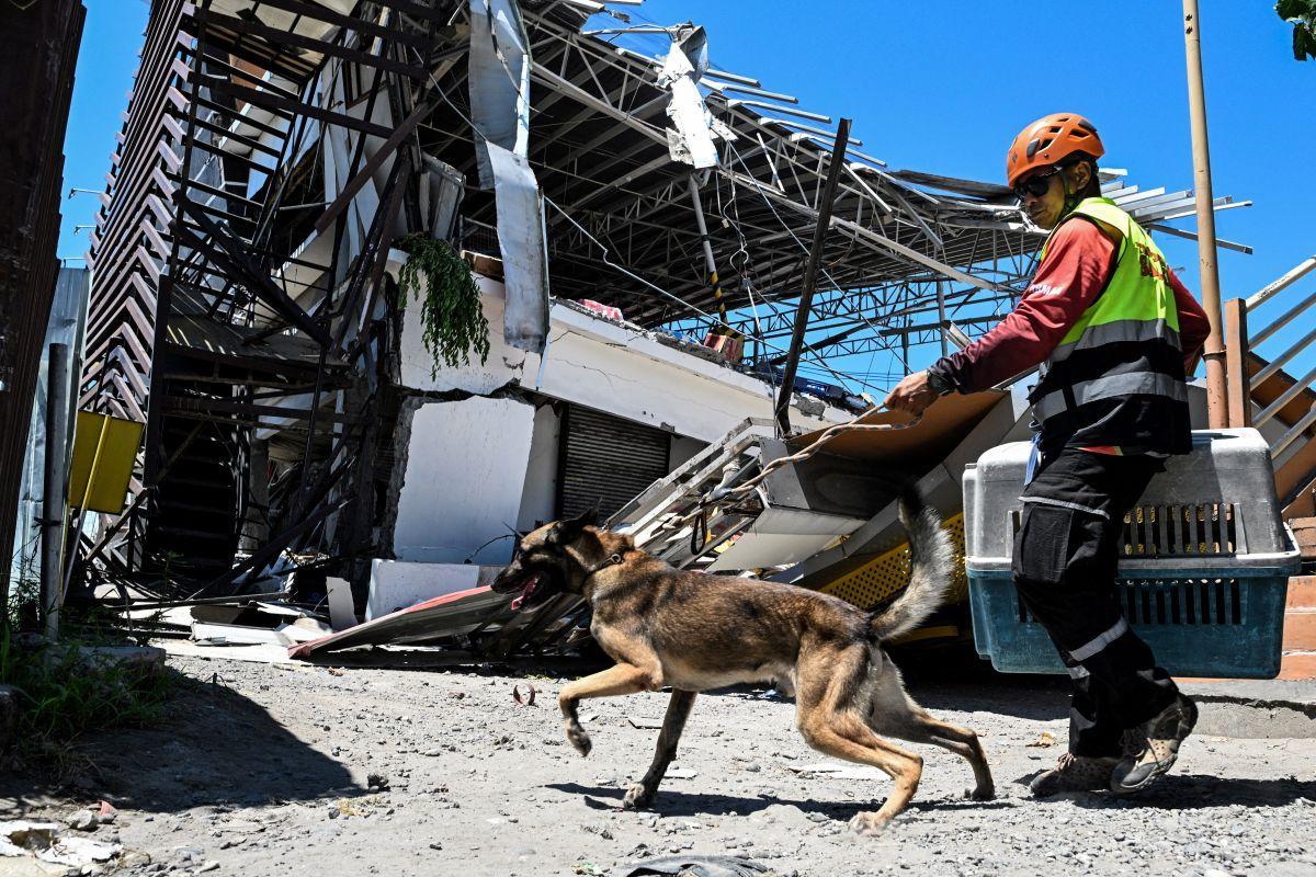
A magnitude 7.8 earthquake struck offshore Sarangani at 7:37 a.m. on Monday, June 8, 2026, killing at least 45 people and prompting PHIVOLCS to issue a tsunami warning.
Tsunami waves were recorded along the coasts of Kiamba and Maasim in Sarangani, Kalamansig in Sultan Kudarat, as well as in Mati City and Zamboanga City.
The earthquake also caused damage in areas adjacent to the epicenter.
PHIVOLCS initially recorded the earthquake at magnitude 7.0 with a shallow depth of 10 kilometers, but later upgraded it to magnitude 7.8 at a depth of 33 kilometers.
It said the earthquake "may be attributed to subduction along the Cotabato Trench."
According to the initial report of the Department of Public Works and Highways (DPWH), 18 bridges in Soccsksargen were damaged, six of which were nearly impassable. At least 41 roads were also affected, with around 20 rendered impassable.
The earthquake likewise triggered six landslides.
Based on reports from the Department of Energy (DOE), around 130,000 consumers remained without electricity as of Monday, while 47 gasoline stations were still non-operational.
Twin earthquakes in Davao Oriental (October 10, 2025)
A magnitude 7.4 earthquake struck east of Manay, Davao Oriental, at 9:43 a.m. It was followed by a separate magnitude 6.8 earthquake 36 kilometers south of Manay at 7:12 p.m.
PHIVOLCS described the second earthquake as the latter half of a doublet rather than an aftershock, referring to two closely timed earthquakes occurring near each other.
The twin earthquakes prompted the declaration of a state of calamity in Manay. The disaster affected 17 barangays, severed power lines, and damaged homes, schools, and bridges.
The Department of Health (DOH) Region 11 recorded at least 10 fatalities across Davao de Oro, Davao Oriental, Davao del Norte, Davao Occidental, and Davao City.
Davao del Sur (December 15, 2019)
In late 2019, a magnitude 6.9 earthquake struck 9 kilometers west of Matanao, Davao del Sur, at a depth of only 3 kilometers.
The earthquake claimed at least four lives and caused damage to Davao International Airport in Davao City, as well as to homes, a grocery store, and a commercial building.
Landslides were also reported in Kiblawan and Matanao, Davao del Sur.
Series of earthquakes in Cotabato and nearby areas (October 2019)
A series of earthquakes ranging from magnitude 6.1 to 6.6 rattled Cotabato Province and nearby areas from October 16 to 31, 2019.
Initial information from PHIVOLCS showed that the earthquakes were generated by the Cotabato Fault System, which traverses the provinces of Cotabato, Davao del Sur, Maguindanao, Sarangani, South Cotabato, and Sultan Kudarat.
Tension cracks were observed, particularly near the epicentral areas of Makilala, Kidapawan City, and Tulunan in Cotabato, as well as in Magsaysay and Bansalan in Davao del Sur.
An earthquake-induced landslide in Barangay Ilomavis, Kidapawan City, buried and swept away houses along its path and placed other upland communities at risk of further landslides.
Several buildings, schools, homes, and government facilities were also damaged.
The National Disaster Risk Reduction and Management Council (NDRRMC) recorded at least six fatalities and more than 300 injuries.
Sultan Kudarat (March 6, 2002)
A powerful magnitude 6.8 tremor jolted Sultan Kudarat, with the epicenter located 81 kilometers southwest of Isulan at a depth of 15 kilometers.
The earthquake killed at least 8 people and damaged schools, road networks, bridges, business establishments, health centers, and public buildings.
Moro Gulf (August 17, 1976)
A magnitude 8.1 earthquake struck Mindanao in the early hours of August 17, 1976, triggering a tsunami that devastated more than 700 kilometers of coastline bordering Moro Gulf in the North Celebes Sea.
The tsunamigenic earthquake claimed 1,440 lives in Region 9 and 3,351 lives in Region 12.
PHIVOLCS attributed the high death toll to the earthquake's midnight occurrence when most people were asleep and the destructive tsunami that followed.
The tsunami battered the coastlines of Region 9—which then included Pagadian City, Zamboanga City, Zamboanga del Sur, Basilan, and Sulu—and Region 12, which then comprised Sultan Kudarat, Maguindanao, Cotabato City, Lanao del Sur, and Lanao del Norte.
—VBL, GMA News
