

PhilSA notes return of nighttime lights in parts of Mindanao after earthquake
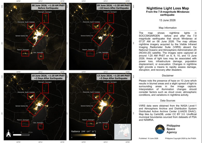
A significant level of nighttime lights has been restored in parts of Mindanao in the wake of the magnitude 7.8 earthquake that rocked the region on June 8, the Philippine Space Agency (PhilSA) said on Tuesday.
In a statement, the agency said this could be used as an alternative to monitor reconstruction and recovery in the affected areas.
In contrast, when lights go out, it often signals power loss, infrastructure damage, or population displacement and evacuation.
“PhilSA’s support through the analysis of satellite data provides wide-area coverage that assists the National Disaster Risk Reduction and Management Council in monitoring the situation and prioritizing areas for response,” PhilSA said.
“By making space data accessible to stakeholders, PhilSA enables informed decision-making and strengthens disaster response,” it added.
PhilSA used nighttime imagery acquired by the Visible Infrared Imaging Radiometer Suite (VIRRS) aboard the National Oceanic and Atmospheric Administration-20 (NOAA-20) satellite.
In making the observation, the agency compared satellite images of SOCCCSKSARGEN taken before the earthquake on June 8 with images captured on June 9, 10, and 13.
Last week, PhilSA observed a decline in nighttime brightness in parts of Mindanao after the destructive earthquake.
Coastal uplift
Following the major earthquake, experts also observed the occurrence of coastal uplifts in some coastlines in Mindanao.
The Philippine Institute of Volcanology and Seismology (PHIVOLCS) earlier defined coastal uplift as a vertical deformation where land along the coastline rises, exposing areas that were previously submerged underwater.
READ: EXPLAINER: What is coastal uplift, and how does it affect humans and wildlife?
Based on the generated maps by PhilSA, shoreline shifts occurred in Barangays Burias and Pangyan in Sarangani.
The shorelines were delineated using visual interpretation and Automated Water Extraction Index (AWEI) analysis of Sentinel-2C satellite imagery acquired on May 10 and June 9, 2026.
PhilSA added that the map visualizations are subject to ground validation. — JMA, GMA News
