

Rolly makes 3rd landfall over San Narciso, Quezon; Signal No. 4 still up in 16 areas
Typhoon Rolly (international name: Goni) made its third landfall over the vicinity of San Narciso, Quezon on Sunday noon, PAGASA said.
In its 2 p.m. severe weather bulletin, the state weather bureau said the center of the eye of Rolly made landfall at 12 p.m. in the area.
Tropical Cyclone Wind Signal No. 4 remained hoisted over the following areas:
- Camarines Norte
- the northwestern portion of Camarines Sur (Sipocot, Lupi, Ragay, Del Gallego)
- Marinduque
- Metro Manila
- Cavite
- Laguna
- Batangas
- Rizal
- Quezon including Polillo Islands
- Pampanga
- Bulacan
- the southern portion of Aurora (Dingalan)
- Bataan
- the southern portion of Zambales (San Marcelino, San Felipe, San Narciso, San Antonio, Castillejos, Subic, Olongapo City, Botolan, Cabangan)
- the northwestern portion of Occidental Mindoro(Mamburao, Paluan) including Lubang Island
- the northern portion of Oriental Mindoro (Victoria, Naujan Lake, Pola, Naujan, Calapan City, Baco, San Teodoro, Puerto Galera)
Areas under TCWS No. 4 should expect winds of 171 to 220 kilometers per hour in 12 hours.
TCWS No. 3 is in effect over:
- The rest of Camarines Sur
- the rest of Zambales
- Tarlac
- the southern portion of Nueva Ecija (Cuyapo, Talugtug, Muñoz City, Llanera, Rizal, Bongabon, Gabaldon, General Tinio, Laur, Palayan City, General Mamerto Natividad, Cabanatuan City, Santa Rosa, Peñaranda, Gapan City, San Isidro, Cabiao, San Antonio, Jaen, San Leonardo, Zaragoza, Aliaga, Talavera, Santo Domingo, Quezon, Licab, Guimba, Nampicuan)
- the central portion of Aurora (San Luis, Baler, Maria Aurora)
- the northern portion of Occidental Mindoro (Santa Cruz, Sablayan)
- Burias Island
- the northern portion of Oriental Mindoro (Socorro, Pinamalayan, Gloria, Bansud, Bongabong, Roxas)
- Romblon
These areas will have winds of 121 to 170 kph in 18 hours, PAGASA said.
TCWS No. 2 is up over:
- The rest of Aurora
- Nueva Vizcaya
- Quirino
- Benguet
- La Union
- Pangasinan
- the rest of Nueva Ecija
- Catanduanes
- Albay
- Sorsogon
- the northern portion of Masbate (Aroroy, Mandaon, Balud, Baleno, Milagros, Masbate City, Mobo, Uson, Cawayan, Dimasalang) including Ticao Island
- the rest of Occidental Mindoro
- the rest of Oriental Mindoro
Winds of 61 to 120 kph will be experienced in these areas in 24 hours.
Meanwhile, TCWS No. 1 is hoisted over:
Luzon
- Mainland Cagayan
- Isabela
- Apayao
- Kalinga
- Mountain Province
- Ifugao
- Abra
- Ilocos Norte
- Ilocos Sur
- the rest of Masbate
- the northern portion of Palawan (El Nido, Taytay, Dumaran, Araceli) including Calamian and Cuyo Islands
Visayas
- The northern portion of Antique (Sebaste, Culasi, Tibiao, Barbaza, Laua-An, Pandan, Libertad, Caluya)
- Aklan
- Capiz
- the northern portion of Iloilo (Lemery, Sara, Concepcion, San Dionisio, Batad, Estancia, Balasan, Carles)
- the northwestern portion of Northern Samar (Allen, Victoria, Lavezares, Rosario, San Jose, Biri, San Isidro, San Antonio, Capul, San Vicente)
Areas under TCWS No. 1 will have winds of 30 to 60 kph in 36 hours.
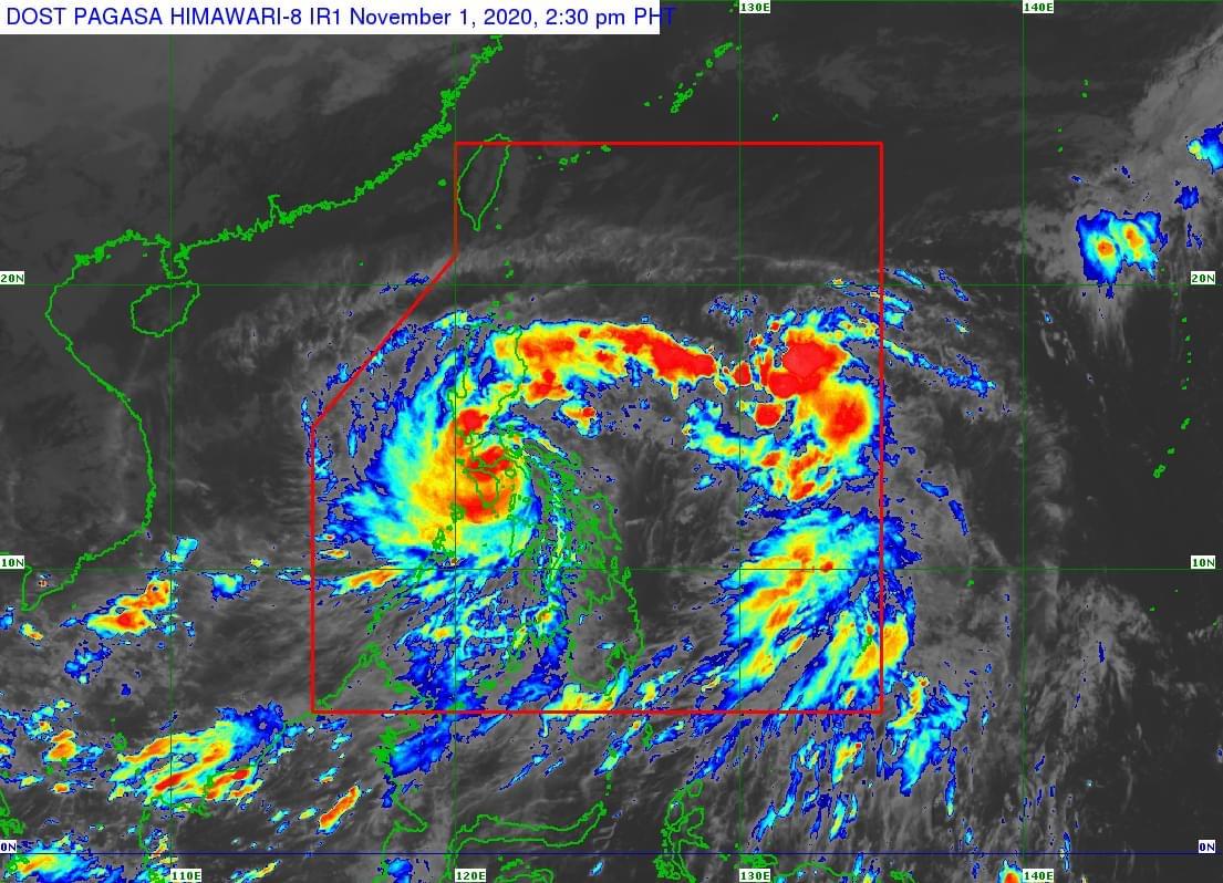
PAGASA said Rolly is further weakening and is now in Mongpong Pass.
The state weather bureau said violent winds and intense rainfall associated with the region of the eyewall and inner rainbands of the typhoon is prevailing or expected within the next 12 hours over Marinduque, Laguna, the eastern portion of Batangas, and Cavite.
The center of the eye of Rolly was located over the coastal waters of Mulanay, Quezon at 1 p.m. with maximum sustained winds of 175 kph near the center and gustiness of up to 240 kph. It is moving westward at 25 kph.
PAGASA said the center of the typhoon will continue to move over the Marinduque-Central Quezon area on Sunday afternoon and towards Batangas-Cavite area on Sunday late afternoon or evening.
Between 4 p.m. to 7 p.m. on Sunday, the center of the eye of Rolly is located around 70 km south of Metro Manila, PAGASA said. It is forecasted to exit the mainland Luzon landmass and emerge over the West Philippine Sea on Sunday night.
“During its traverse of Southern Luzon, Rolly is forecast to weaken but will emerge as a typhoon over the West Philippine Sea,” PAGASA said.
Hazards
PAGASA said Rolly will bring heavy to intense rains over CALABARZON, Metro Manila, Marinduque, Romblon, Mindoro Provinces, Bataan, Bulacan, Aurora, and the eastern portions of mainland Cagayan and Isabela on Sunday, while moderate to heavy rains will be experienced over Cordillera Administrative Region, and the rest of mainland Cagayan Valley and Central Luzon.
Light to moderate, with at times, heavy rains will also prevail over Zamboanga Peninsula, Bangsamoro, Western Visayas, and the rest of Luzon.
PAGASA advised affected residents to prepare for possible flash floods and landslides during heavy or prolonged rainfall.
It said very destructive to devastating typhoon-force winds will be experienced in areas under TCWS No. 4, while destructive typhoon-force winds will prevail in areas under TCWS No. 3.
Damaging gale to storm-force winds will also prevail in areas under TCWS No. 2, while strong breeze to near gale conditions shall be expected in areas under TCWS No. 1.
“Elsewhere, strong breeze to near gale conditions due to the northeasterlies will be experienced over the rest of Northern Luzon that are not under TCWS No. 1,” PAGASA said.
PAGASA also said a storm surge of up to 3.0 meters might be experienced over the northern coastal areas of Quezon including Polillo Islands, coastal areas of Metro Manila, Cavite, Bulacan, Pampanga, Bataan, the southeastern coastal area of Batangas (facing Tayabas Bay), and most of the southern coastal areas of Quezon in the next 24 hours.
A storm surge of up to 2.0 meters, meanwhile, might be experience over the coastal areas of Marinduque, Lubang Island, Albay, Masbate (including Ticao and Burias Islands), the northern coastal area of Mindoro Provinces, and the remaining coastal areas of Quezon, and Batangas.
“[T]here is also a moderate to high risk of seiche or storm surge over the coastal areas surrounding Laguna de Bay and Taal Lake. These storm surges, which may be accompanied by swells and breaking waves reaching the coast can cause life-threatening and damaging coastal inundation,” PAGASA added.
Further, rough to phenomenal seas will be experienced over the seaboard of areas where TCWS is in effect and rough to very rough seas (2.5 to 5.0 m) over the remaining seaboards of Northern Luzon and the eastern seaboards of Eastern Visayas (that are not under TCWS) and Caraga on Sunday.
Moderate to rough seas (1.2 to 2.5 m), meanwhile, will be experienced over the remaining seaboards of the country.
“Mariners of small seacrafts are advised to take precautionary measures when venturing out to sea. Inexperienced mariners should avoid navigating in these conditions,” PAGASA said.
Casualties, stranded passengers
Albay province reported four casualties due to the onslaught of Typhoon Rolly.
"Apat na. Sa ngayon, apat 'yung accounted for. 'Yung tatlo related sa ilog, nagoverflow, nawasak 'yung dike at 'yun 'yung mga namatay," Governor Al Francis Bichara told Dobol B sa News TV.
Meanwhile, 1,960 passengers and workers are stranded in ports in different parts of the country.
The Philippine Coast Guard said those stranded were passengers, truck drivers, and cargo helpers from the Bicol Region, Southern Tagalog, National Capital Region, and Eastern Visayas.—AOL, GMA News
