

Two areas under Signal No. 3 as Rolly now over West Philippine Sea
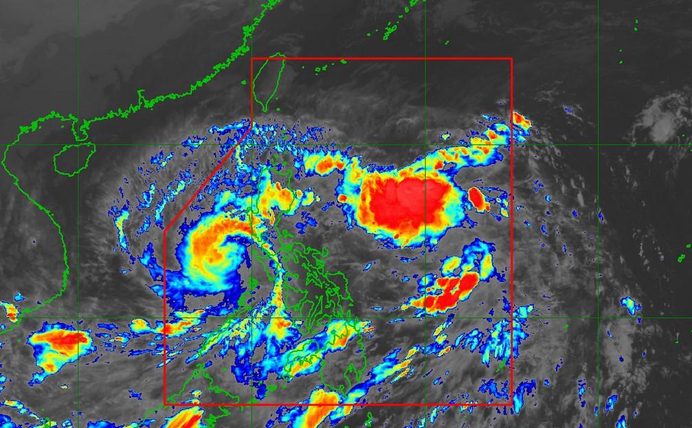
Only two areas are still under Tropical Cyclone Wind Signal No. 3 as Typhoon Rolly continued to weaken, PAGASA said Sunday night.
In its 8 p.m. severe weather bulletin, PAGASA said Rolly is now over the West Philippine Sea packing maximum sustained winds of 125 kilometers per hour (kph) and gustiness of up to 170 kph.
The typhoon continues to move westward at 25 kph and is forecast to exit the Philippine Area of Responsibility on Tuesday morning.
PAGASA said Rolly will likely weaken into a severe tropical storm within the next 24 hours.
Signal No. 3 was hoisted over the following areas:
- The southwestern portion of Batangas (Tingloy, Mabini, Bauan, San Luis, Taal, Santa Teresita, Alitagtag, Taal lake, San Nicolas, Talisay, Laurel, Agoncillo, Lemery, Calaca, Balayan, Tuy, Nasugbu, Lian, Calatagan)
- The northwestern portion of Occidental Mindoro (Abra de Ilog, Mamburao, Paluan)
Signal No. 2 was raised over:
- Cavite
- The rest of Batangas
- The northern portion of Oriental Mindoro (Puerto Galera, San Teodoro, Baco, Calapan City, Naujan, Victoria, Pola)
- The central portion of Occidental Mindoro (Santa Cruz, Sablayan)
- The southern portion of Zambales (San Marcelino, San Felipe, San Narciso, San Antonio, Castillejos, Subic, Olongapo City)
Casualties
As of 8:30 p.m., 10 fatalities have been recorded by the Office of Civil Defense: nine persons in Albay and one man in Catanduanes.
In Guinobatan, Albay, some 180 houses were submerged by lahar flow triggered by the typhoon, killing at least one person.
In Batangas—where Rolly made its fourth landfall, in the town of Lobo, at 5:30 p.m.—floodwaters reached the roofs of houses, forcing residents to flee.
In Metro Manila, at least 400 families had to be evacuated in Manila, while Barangay Palingon in Taguig City received evacuees as Laguna de Bay overflowed.
Globe Telecom, meanwhile, reported several service disruptions in BIcol and other parts of Luzon due to fiber cuts.
Hazards
PAGASA said Rolly would bring moderate to heavy with at times intense rains over Aurora and the eastern portions of mainland Cagayan and Isabela.
Light to moderate with ati times heavy rains will prevail over Metro Manila, CALABARZON, Cordillera Administrative Region, Ilocos Region, MIMAROPA, Western Visayas, Zamboanga Peninsula, Bangsamoro, Northern Mindanao, and the rest of mainland Cagayan Valley and Central Luzon.
The state weather bureau added that destructive typhoon-force winds will be experienced in areas under Signal No. 3, damaging gale- to storm-force winds in areas under Signal No. 2, and strong breeze to near gale conditions in areas under Signal No. 1.
“Elsewhere, strong breeze to near gale conditions due to the northeasterlies will be experienced over Northern Luzon,” PAGASA said.
The bureau also warned of a “moderate to high risk” of storm surge up to 2 meters over the coastal areas of Cavite, Bataan, Lubang Island, the southwestern coastal area of Batangas, and the northern coastal area of Occidental Mindoro.
Rough to high seas (2.5 to 9.0 meters) will also be experienced over the seaboard of areas under a storm signal while rough to very rough seas (2.5 to 5.0 meters) will prevail over the remaining seaboards of Northern Luzon and the eastern seaboards of Eastern Visayas, and Caraga.
Moderate to rough seas (1.2 to 2.5 meters) will be experienced over the remaining seaboards of the country, PAGASA added. -NB, GMA News
