

Egay rapidly intensifies; Signal No. 2 up over parts of Isabela, Catanduanes
Tropical Cyclone Wind Signal (TCWS No. 2) was hoisted over parts of Isabela and Catanduanes on Monday due to Typhoon Egay (international name: Doksuri) which is rapidly intensifying over the Philippine Sea, PAGASA said in its bulletin.
TCWS No. 2 was raised over the following areas:
- the southeastern portion of Isabela (Palanan, Dinapigue); and
- the northeastern portion of Catanduanes (Pandan, Bagamanoc, Panganiban, Viga, Gigmoto).
These areas will have gale-force winds ranging from 62 to 88 km/h in 24 hours. PAGASA said these winds may pose minor to moderate threat to life and property.
TCWS No. 1 on the other hand was raised over these areas:
- Batanes;
- Cagayan including Babuyan Islands;
- the rest of Isabela;
- Quirino;
- Nueva Vizcaya;
- Apayao;
- Kalinga;
- Abra;
- Mountain Province;
- Ifugao;
- Benguet;
- Ilocos Norte;
- Ilocos Sur;
- La Union;
- the northern portion of Pangasinan (Natividad, San Nicolas, San Quintin, Sison, Pozorrubio, San Manuel, San Fabian, Anda, Bolinao, San Jacinto, Manaoag, Laoac, Binalonan, Asingan, Tayug, Santa Maria, Umingan, Dagupan City, Mangaldan);
- Aurora;
- the northern and eastern portions of Nueva Ecija (Carranglan, Bongabon, Gabaldon, Pantabangan, Lupao, San Jose City);
- the northern and southeastern portions of Quezon (Pitogo, San Andres, Buenavista, San Francisco, Calauag, Infanta, Lopez, Catanauan, Mulanay, Guinayangan, Unisan, General Luna, Plaridel, Quezon, Alabat, Padre Burgos, Macalelon, Mauban, General Nakar, Perez, Agdangan, Gumaca, Atimonan, Real, San Narciso, Tagkawayan) including Polillo Islands;
- Camarines Norte;
- Camarines Sur;
- the rest of Catanduanes;
- Albay;
- Sorsogon;
- Masbate;
- Northern Samar;
- Eastern Samar;
- Samar; and
- Biliran.
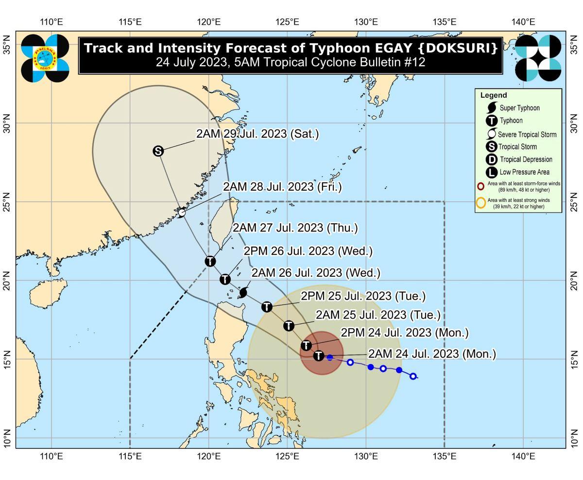
At 4 a.m., the center of Egay was estimated to be located at 565 km east of Baler, Aurora.
It has maximum sustained winds of 140 km/h near the center, gustiness of up to 170 km/h, and central pressure of 965 hPa.
Egay is moving westward at 15 km/h over the Philippine Sea.
From its center, strong to typhoon-force winds are extending outwards up to 600 km.
Egay is forecast to cross the Luzon Strait and make landfall or pass very close to Babuyan Islands and Batanes areas between Tuesday late evening and Wednesday afternoon.
"EGAY is forecast to continue intensifying and reach super typhoon category by late tomorrow or on early Wednesday," PAGASA said.
However, if Egay shifts its track, it may peak at an intensity just below the super typhoon threshold, it added.
Rainfall
Catanduanes, the northeastern portion of Camarines Sur, and the northern portion of Camarines Norte may have 50-100 mm of rainfall on Monday, PAGASA said.
On Tuesday, the northeastern portion of mainland Cagayan may expect rainfall above 200 mm.
The rest of Cagayan including Babuyan Islands, Ilocos Norte, Ilocos Sur, the western portion of Abra and the northern portion of Apayao may have 100 to 200 mm of rainfall on Tuesday.
Meanwhile, 50 to 100 mm of rain is forecast for Batanes, the northern and eastern portions of Isabela, the rest of Apayao, the rest of Abra, Kalinga, the western portion of Mountain Province, Benguet, La Union, and the western portion of Pangasinan on Tuesday.
On Wednesday, the forecast accumulated rainfall is as follows:
•Above 200 mm: Batanes, Babuyan Islands, and Ilocos Norte
•100-200 mm: The northern portion of mainland Cagayan, Apayao, Abra, and Ilocos Sur,
•50-100 mm: The rest of mainland Cagayan, Kalinga, the western portion of Mountain Province, Benguet, La Union, and Pangasinan.
PAGASA said elevated or mountainous areas may have generally higher amount of rainfall.
"Under these conditions, flooding and rain-induced landslides are highly likely especially in areas that are highly or very highly susceptible to these hazard as identified in hazard maps and in localities that experienced considerable amounts of rainfall for the past several days," PAGASA said.
"EGAY may also enhance the Southwest Monsoon, bringing occasional to monsoon rains over the western portions of Central Luzon, Southern Luzon, and Visayas in the next three days," it added.
Severe winds
PAGASA said the highest TCWS that may be raised is Signal No. 4 or 5.
Gusty conditions may also be experienced in the following areas not under any TCWS, especially in coastal and upland/mountainous areas exposed to winds, due to Egay and the monsoon:
• Monday: Calabarzon, Mimaropa, Visayas, and the northern portions of Zamboanga Peninsula, Northern Mindanao, and Caraga.
• Tuesday: Luzon, Visayas, Zamboanga Peninsula, Basilan, Sulu, Tawi-Tawi, and the northern portion of Northern Mindanao and Dinagat Islands.
• Wednesday: Luzon and Visayas.
Coastal waters
A gale warning was raised over several coastal waters along the northern and eastern seaboards of Northern Luzon, the eastern seaboard of Central Luzon, the seaboards of Southeastern Luzon, and the eastern seaboards of Visayas and Northeastern Mindanao due to Egay.
"Sea travel is risky for small seacrafts. For larger vessels, operating in gale conditions requires experience and properly equipped vessels. Mariners without proper experience or operating ill-equipped vessels are advised to remain in port or seek safe harbor," PAGASA said.
Coastal waters outside the gale warning area along the western and southern seaboards of Southern Luzon, the remaining seaboards of Visayas, and the eastern seaboard of Mindanao may have moderate to rough seas (up to 3 meters) in the next 24 hours due to Egay, the weather bureau added.
"Mariners of small seacrafts are advised to take precautionary measures when venturing over these waters. If inexperienced or operating ill-equipped vessels, avoid navigating in these conditions," PAGASA said.
Track, intensity outlook
Egay is expected to turn northwestward after a brief period of westward or west northwestward movement.
It will then head closer to the landmass of Northern Luzon towards the Luzon Strait, then make landfall or pass very close to the Babuyan Islands-Batanes area late evening Tuesday up to Wednesday afternoon.
Egay is expected to exit the Philippine Area of Responsibility (PAR) on Thursday, then traverse the waters southwest of Taiwan.
"Outside the PAR, the typhoon will cross the Taiwan Strait and make landfall over Fujian, China on late Thursday or early Friday," PAGASA said.
The weather bureau however said there is a possibility that there will be a further shift in the track forecast due to a ridge of high pressure north of Typhoon Egay. Thus the possibility of Egay making landfall over the northeastern portion of mainland Cagayan is not ruled out, PAGASA added.
Egay may begin weakening on Wednesday afternoon or evening as it traverses the cooler waters southwest and west of Taiwan, the weather bureau said.
PAGASA advised the public and disaster risk reduction and management offices concerned to take the necessary measures to protect life and property.
The next bulletin will be issued by PAGASA at 11 a.m.
Flight cancellations
Meanwhile, at least two domestic flights have been canceled due to bad weather.
According to the Manila International Airport Authority, the following flights have been canceled:
Cebu Pacific (5J):
- 5J 821/822 Manila-Virac-Manila.
—KG/RSJ, GMA Integrated News

