

Aurora, parts of Calabarzon under Signal No. 2 as Aghon maintains strength
Tropical Cyclone Wind Signal (TCWS) No. 2 was hoisted over the province of Aurora, as well as other areas in Calabarzon, early Sunday afternoon as Tropical Storm Aghon (international name: Ewiniar) maintained its strength, state weather bureau PAGASA said.
Based on its 2 p.m. bulletin, PAGASA said TCWS No. 2, which has gale-force winds, was raised over the following areas:
- Aurora;
- the northern and central portions of Quezon (Alabat, Perez, Quezon, Gumaca, Lopez, Macalelon, General Luna, Unisan, Pitogo, Plaridel, Agdangan, Padre Burgos, Atimonan, Mauban, Real, General Nakar, Infanta, Sampaloc, Pagbilao, Calauag, Lucban, City of Tayabas, Lucena City, Tiaong, Candelaria, Sariaya, Dolores, San Antonio) including Polillo Islands;
- Laguna;
- the eastern portion of Batangas (City of Tanauan, San Jose, Lipa City, Mataasnakahoy, Balete, Malvar, Santo Tomas, Cuenca, San Pascual, Batangas City, Ibaan, Padre Garcia, Rosario, San Juan, Taysan, Lobo); and
- the eastern portion of Rizal (Jala-Jala, Pililla, Tanay, Cardona, Binangonan, Morong, Baras).
Wind speeds ranging 62 to 88 km/h may be expected in these areas within the next 24 hours. Wind impacts may also result in minor to moderate threat to life and property.
Meanwhile, the following areas were under TCWS No. 1:
- the eastern portion of Isabela (Divilacan, San Mariano, San Guillermo, Jones, Echague, San Agustin, Ilagan City, Benito Soliven, City of Cauayan, Maconacon, Angadanan, Naguilian, Palanan, Dinapigue);
- the eastern portion of Quirino (Maddela, Nagtipunan, Aglipay);
- the southern portion of Nueva Vizcaya (Alfonso Castaneda, Dupax del Sur, Dupax del Norte);
- the eastern and southern portions of Nueva Ecija (General Tinio, Gabaldon, Bongabon, Pantabangan, Rizal, General Mamerto Natividad, Laur, Palayan City, Peñaranda, San Leonardo, City of Gapan, Cabanatuan City, Santa Rosa, San Isidro, Cabiao, San Antonio, Jaen, Zaragoza, Aliaga, Talavera, Llanera);
- the southern portion of Bataan (Orani, Samal, City of Balanga, Abucay, Pilar, Orion, Limay, Mariveles, Bagac);
- the eastern portion of Pampanga (Candaba, San Luis, San Simon, Apalit, Santa Ana, Arayat, Mexico, Santa Rita, Guagua, Sasmuan, Macabebe, Masantol, Santo Tomas, Minalin, City of San Fernando, Bacolor, Lubao);
- Bulacan;
- Metro Manila;
- the rest of Quezon;
- the rest of Rizal;
- Cavite;
- the rest of Batangas;
- the northern and central portions of Oriental Mindoro (Pinamalayan, Pola, Naujan, Victoria, Socorro, City of Calapan, Bansud, Gloria, Baco, San Teodoro, Puerto Galera, Bongabong);
- Marinduque;
- the extreme northern portion of Romblon (Concepcion, Corcuera, Banton);
- Camarines Norte; and
- Camarines Sur.
Strong winds ranging 39 to 61 km/h may occur in the above areas within the next 36 hours. Wind impacts may result in minimal to minor threat to life and property.
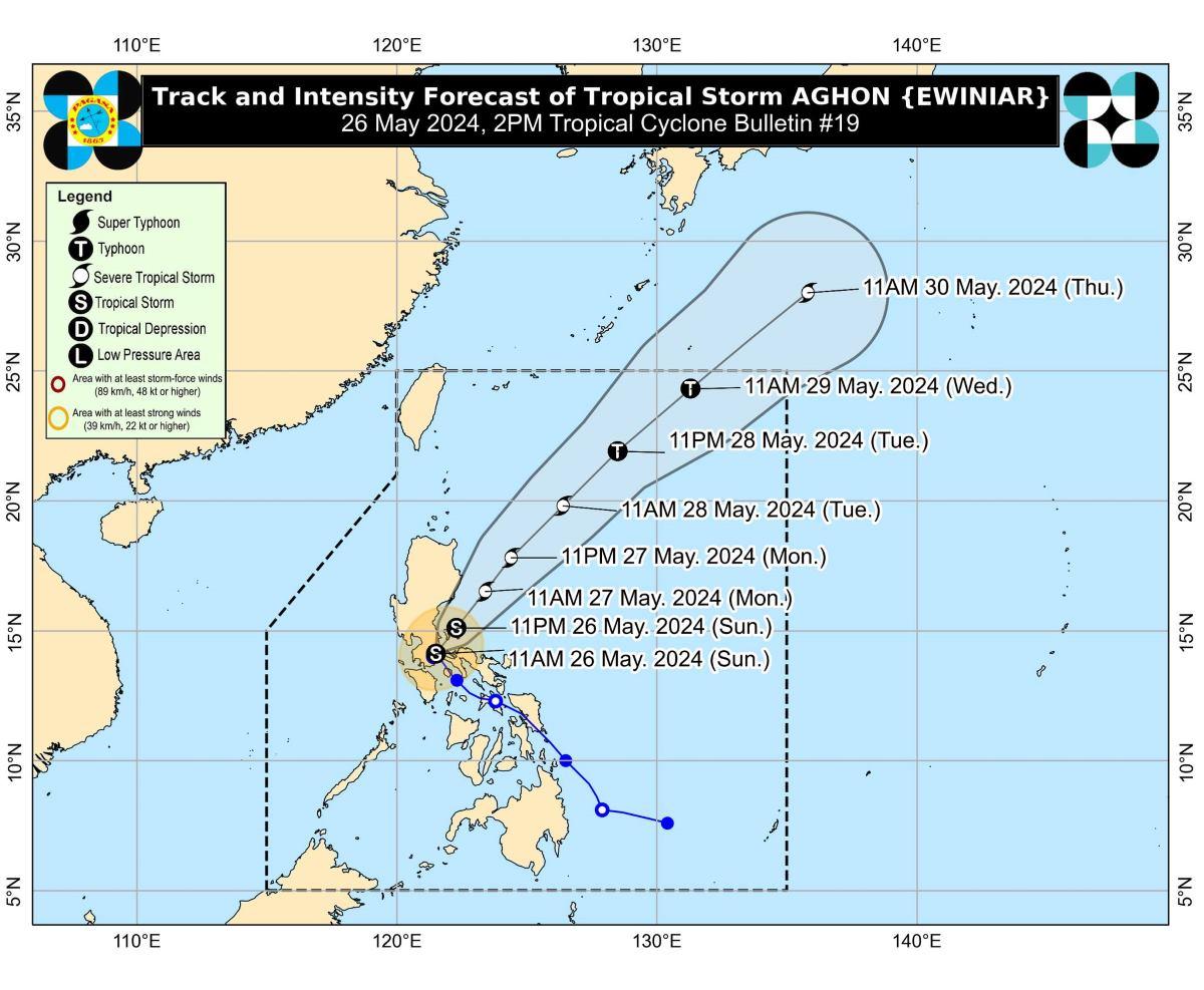
According to PAGASA, the center of Aghon was located at 1 p.m. in the vicinity of Mauban, Quezon. It has maximum sustained winds of 75 km/h near the center, gustiness of up to 125 km/h, and central pressure of 996 hPa.
The tropical storm was also slowly moving northeastward, with strong to gale-force winds extending outwards up to 220 km from the center.
PAGASA said that more areas in Cagayan Valley and Central Luzon may be placed under TCWS No.1 in the next bulletin set to be issued by 5 p.m.
Hoisting of TCWS No. 3 over the eastern sections of Aurora and Quezon is also possible.
Coastal waters
Within the next 24 hours, PAGASA said there is a minimal to moderate risk of storm surge over the exposed and low-lying coastal areas of Cagayan, Isabela, Central Luzon, Metro Manila, Calabarzon, Mindoro Provinces, Marinduque, Romblon, Camarines Norte, Camarines Sur, and Burias Island.
A gale warning was also raised over the coastal waters of Aurora, Quezon, and Marinduque, and the southern coastal waters of Batangas, and the northern coastal waters of Camarines Norte.
Sea travel is thus risky for small seacrafts, including all motorbancas of any type of tonnage in these areas.
Aghon will also bring moderate to rough seas (1.5 to 3.5 m) over the coastal waters along the northern and eastern seaboards of Luzon and the seaboard of Bicol Region.
Track, intensity
In the next 12 hours, PAGASA said Aghon will move across mainland Quezon and Polillo Islands.
The tropical storm is also expected to be over the waters off the east coast of Quezon on Sunday evening. During this period, Aghon will likely remain as a tropical storm, but it may also intensify into a severe tropical storm while over the sea east of Quezon.
From Monday through the remainder of the forecast period, Aghon will also gradually accelerate northeastward while intensifying.
It is forecast to reach typhoon category by Tuesday afternoon or evening, and may eventually exit the Philippine Area of Responsibility on Wednesday.
Four persons, including three minors, were injured in Legazpi, Albay due to Aghon, the National Disaster Risk Reduction and Management Council (NDRRMC) said Sunday.
The Office of Civil Defense will also verify reports that one person was killed in Northern Mindanao because of the tropical storm.
Meanwhile, at least 6,000 passengers and 800 rolling cargoes were stranded on Sunday due to Aghon, according to the Philippine Coast Guard.
Some flights for Sunday, May 26, were canceled due to the bad weather caused by the storm. —KG, GMA Integrated News
