

PAGASA: Tino maintains strength, Signal No. 4 in 5 areas
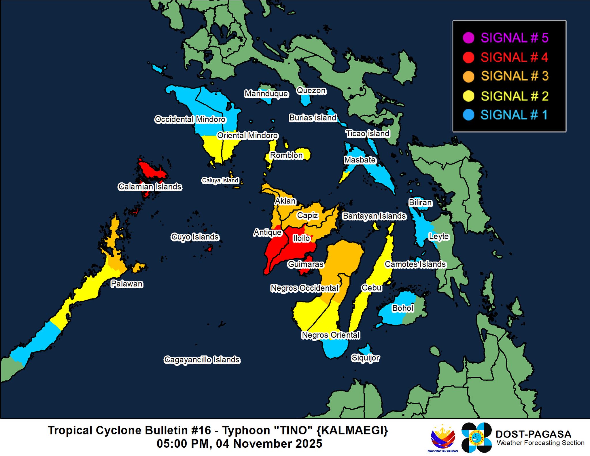
Five areas are under Signal No. 4 as Typhoon Tino sustains its strength and is about to emerge over the Sulu Sea, PAGASA said late Tuesday afternoon.
At 4 p.m., Tino was located in the vicinity of Patnongon, Antique.
It is carrying maximum sustained winds of 130 km/h near the center and gusts of up to 180 km/h, and is moving northwestward at 15 km/h.
Based on the state weather bureau’s 5 p.m. weather bulletin, Signal No. 4 is hoisted in the following areas:
Luzon- Calamian
- Cuyo Islands
Visayas
- The central and southern portions of Antique (Patnongon, Sibalom, Valderrama, Hamtic, San Jose, Bugasong, Anini-Y, San Remigio, Belison, Tobias Fornier, Laua-An)
- The central and southern portions of Iloilo (Calinog, New Lucena, Maasin, Oton, Pavia, Dueñas, Barotac Nuevo, Guimbal, Iloilo City, Tigbauan, San Miguel, Leon, Mina, Santa Barbara, Leganes, Dingle, Zarraga, Bingawan, Cabatuan, Alimodian, Dumangas, San Joaquin, Badiangan, Pototan, Lambunao, Tubungan, Igbaras, Janiuay, Miagao)
- Guimaras
The following areas are under Signal No. 3:
Luzon
- The northernmost portion of mainland Palawan (El Nido, Taytay, Dumaran, Araceli)
Visayas
- The rest of Antique, including Caluya Islands
- Aklan
- Capiz
- The rest of Iloilo
- The northern and central portions of Negros Occidental (Hinigaran, Moises Padilla, Isabela, Binalbagan, City of Himamaylan, San Carlos City, Calatrava, City of Escalante, Sagay City, Toboso, Salvador Benedicto, La Carlota City, Cadiz City, Bago City, Enrique B. Magalona, Valladolid, San Enrique, Bacolod City, La Castellana, Murcia, Silay City, Pulupandan, City of Victorias, City of Talisay, Pontevedra, Manapla)
- The northern portion of Negros Oriental (City of Guihulngan, La Libertad, Jimalalud, Canlaon City, Vallehermoso)
Signal No. 2 is up in the following areas:
Luzon
- The southwestern portion of Masbate (Balud)
- The southern portion of Oriental Mindoro (Bulalacao, Mansalay, Roxas, Bongabong)
- The southern portion of Occidental Mindoro (Magsaysay, San Jose, Rizal, Calintaan)
- The southern portion of Romblon (Santa Fe, Santa Maria, Looc, Alcantara, Cajidiocan, Odiongan, San Jose, Ferrol, Romblon, San Andres, Magdiwang, Calatrava, San Agustin, San Fernando)
- The northern portion of Palawan (San Vicente, Roxas, Puerto Princesa City), including the Cagayancillo Islands
Visayas
- Cebu including Bantayan Islands
- The central portion of Negros Oriental (Tayasan, Manjuyod, Bais City, Mabinay, Bindoy, Ayungon, City of Tanjay, Pamplona, Amlan, San Jose, City of Bayawan, Basay)
- The rest of Negros Occidental
The following areas are under Signal No. 1:
Luzon
- The southern portion of Quezon (San Francisco, San Andres)
- The southern portion of Marinduque (Torrijos, Buenavista, Gasan, Boac)
- The rest of Oriental Mindoro
- The rest of Occidental Mindoro, including Lubang Island
- The rest of Romblon
- The rest of Masbate, including Burias and Ticao Islands
- The central portion of Palawan (Aborlan, Quezon, Narra, Sofronio Española)
Visayas
- Biliran
- The northwestern portion of Leyte (Calubian, Leyte, San Isidro, Tabango, Capoocan, Kananga, Ormoc City, Palompon, Isabel, Merida, Villaba, Matag-Ob, Albuera)
- Camotes Islands
- The northern and western portions of Bohol (Antequera, Bien Unido, Sevilla, Loboc, Tagbilaran City, Trinidad, Maribojoc, Lila, Corella, Loon, Dagohoy, Dimiao, Catigbian, Alburquerque, Dauis, Sikatuna, Buenavista, Talibon, Baclayon, Batuan, Sagbayan, San Miguel, Getafe, Loay, Tubigon, Inabanga, Carmen, Panglao, Clarin, Calape, Cortes, San Isidro, Danao, Balilihan, Bilar)
- Siquijor
- The rest of Negros Oriental
PAGASA said the surge of the Northeast Monsoon (Amihan), shear line and the trough of Tino will bring strong to gale-force gusts over Luzon, Western Visayas, Negros Island Region, Central Visayas, Biliran, Leyte, and Zamboanga Peninsula, which are not any under Wind Signal.
Within the next 48 hours, a high risk of life-threatening and damaging storm surge with peak heights exceeding 3.0 m is expected over the low-lying or exposed coastal communities of Romblon, Oriental Mindoro, Occidental Mindoro, Palawan, Western Visayas, Negros Occidental, and Negros Oriental.
A gale warning is also in effect over the western and southern seaboards of Southern Luzon and the western seaboards of Visayas.
“Heavy rainfall, severe winds, and storm surge may still be experienced in localities outside the landfall point and the forecast confidence cone,” PAGASA said.
Tino is expected to emerge at the Sulu Sea this afternoon or evening and is forecast to traverse the northern Palawan area by early Wednesday morning.
It is then forecasted to emerge over the West Philippine Sea on Wednesday morning and may exit the Philippine Area of Responsibility by tomorrow evening or Thursday
“Tino is forecast to steadily re-intensify over the next days and may reach its peak intensity while over the West Philippine Sea,” PAGASA said.
