ADVERTISEMENT
LIVE
Filtered By: Weather
Weather

LIVE UPDATES: Habagat rains affect parts of PH on Tuesday, Sept. 1, 2026


+
Add GMA on Google
Make this your preferred source to get more updates from this publisher on Google.
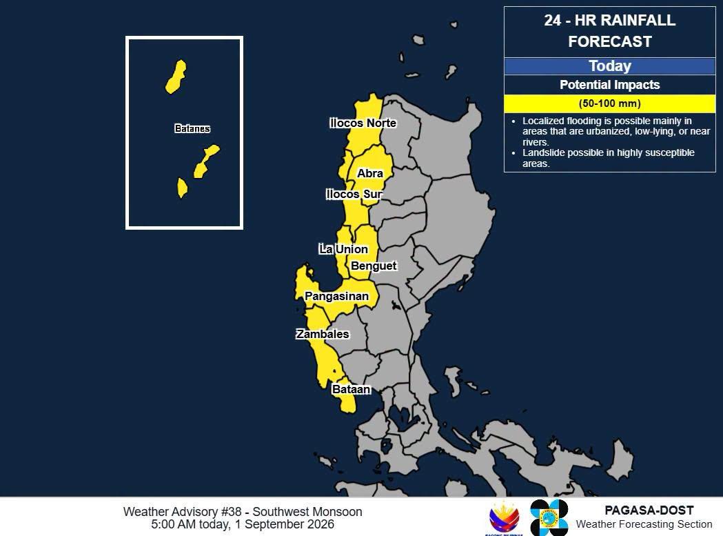
Heavy rainfall outlook due to the Southwest Monsoon, Sept. 1, 2026.
Auto-refresh

NLEX ADVISORY: Sta. Rita northbound entry passable to all vehicles ( Tuesday, 5:05 a.m.)

The NLEX Corporation, in its latest advisory, announced that the Sta. Rita Northbound entry is now passable to all types of vehicles.

Northbound

  •     Libtong Exit - temporarily closed due to flooding at the local road
  •     Sta. Rita Northbound entry - passable to all types of vehicles
  •     Pulilan Northbound entry - temporarily closed due to flooding at the local road
  •     Candaba viaduct - passable to all types of vehicles, heavy traffic
  •     Tulaoc (San Simon)
    •         Lane 1 passable to SUVs, pick ups, and Class 2 and 3 vehicles
    •         Lane 2 passable to Class 2 and 3 vehicles
    •         water build up in all lanes due to rising water level in the Pampanga River, heavy traffic
  •     San Simon Interchange
    •         Lane 1, passable to Class 2 and 3 vehicles
    •         Not passable to Class 1 vehicles
    •         water build up in all lanes due to rising water level in the Pampanga River, heavy traffic

Southbound

  •     Balintawak - passable, All types of vehicles, light
  •     San Simon Southbound entry - passable, All types of vehicles, light
  •     San Fernando Southbound - passable, All types of vehicles, light
  •     Mexico Southbound entry - passable, All types of vehicles, light
  •     Tulaoc (San Simon)
    •         Lane 1 passable for Class 1, 2, and 3 vehicles
    •         Lane 2 passable for Class 2 and 3 vehicles
    •         water build up in all lanes due to rising water level in the Pampanga River, heavy traffic
  •     San Simon Interchange
    •         Lane 1 passable to Class 2 and 3 vehicles
    •         water build up in all lanes due to rising water level in the Pampanga River, heavy traffic

— BAP, GMA News

RAINFALL ALERT: Light to moderate rains over Nueva Ecija, Bulacan (Tuesday 5 a.m.)

The state weather bureau PAGASA, in its rainfall advisory posted early Tuesday morning, said that the Southwest Monsoon (Habagat) will bring light to moderate rains over some areas in Luzon.

Light to moderate with occasional heavy rains are expected over the following areas:

  •     Nueva Ecija (Licab, Guimba, Zaragoza)
  •     Bulacan (Hagonoy, Calumpit, Paombong, Malolos)

Light to moderate with occasional heavy rains affecting the following areas:

  •     Zambales (Subic, Castillejos, San Marcelino, Botolan, Olongapo)
  •     Bataan (Dinalupihan, Limay)
  •     Pampanga (Lubao, Floridablanca, Porac, Masantol, Macabebe, Sasmuan)
  •     Tarlac (San Jose, Capas, Bamban, Victoria, Tarlac City, La Paz)

— BAP, GMA News

Pilandok maintains strength; Habagat to bring rains over Luzon, western Visayas

Tropical Depression Pilandok maintained its strength as it moved west northwestward as the Southwest Monsoon (Habagat) is expected to bring rains over Luzon and western Visayas on Tuesday, PAGASA reported.

According to PAGASA's 5 a.m. Tropical Cyclone Bulletin, the center of Tropical Depression Pilandok was estimated at 1,050 km east of Extreme Northern Luzon packing maximum sustained winds of 55 kilometers per hour near the center, gustiness of up to 70 km/h,and moving west northwestward at 10 km per hour.

There are no tropical cyclone wind signals raised.

The Southwest Monsoon will bring cloudy skies with occasional rains over Luzon and the western section of the Visayas on Tuesday, PAGASA reported.

According to PAGASA's heavy rainfall outlook, 50-100 mm rainfall is expected over Ilocos Norte, Ilocos Sur, La Union, Pangasinan, Batanes, Abra, Benguet, Zambales, and Bataan.

Severe Winds

The Southwest Monsoon will bring strong to gale-force gusts over the following areas (especially in coastal and upland areas exposed to winds) today until Thursday, September 3, 2026: Most of Luzon and Visayas, Zamboanga del Norte, Misamis Occidental, Lanao del Norte, Misamis Oriental, Camiguin, Dinagat Islands, Davao Occidental, and Davao Oriental.

Hazards affecting coastal waters

A Gale Warning is in effect over the northern and western seaboards of Northern Luzon.

Sea travel is risky, PAGASA said, adding that mariners must remain in port or, if underway, seek shelter or safe harbor as soon as possible until winds and waves subside.

Track and Intensity Outlook

Tropical Depression Pilandok is forecast to slowly turn east northeastward then northward over the next 24 hours then move generally north northwestward for the remainder of the forecast period.

Pilandok is forecast to exit the Philippine Area of Responsibility (PAR) by Wednesday evening, September 2, 2026 or Thursday morning.

"This tropical cyclone is less likely to make landfall over the country and will remain far from the Philippine landmass," the weather bureau said.

"Pilandok is forecast to intensify into a tropical storm within the next 12 hours and may remain as a tropical storm as it moves towards southern Japan," it added. — BAP, GMA News

Occasional rains expected over Luzon, western Visayas due to habagat — PAGASA

The Southwest Monsoon (Habagat) will bring cloudy skies with occasional rains over Luzon and the western section of the Visayas on Tuesday, PAGASA reported.

As of 3 a.m., Tropical Depression Pilandok is located 1,060 kilometers east of extreme Northern Luzon packing maximum sustained winds of 55 kilometers per hour near the center, gustiness of up to 70 km/h, moving in the west northwest direction at the speed of 10 km/h.

PAGASA continues to monitor two tropical cyclones outside the Philippine Area of Responsibility (PAR).

Saudel (formerly Obet) has re-intensified into a tropical storm and is located 985 km west of extreme Northern Luzon packing maximum sustained winds of 65 km/h near the center, gustiness of up to 80 km/h, and moving east southeastward at the speed of 15 km/h.

Another tropical depression, formerly LPA 08I, is located 645 km west northwest of Itbayat, Batanes, packing maximum sustained winds of 45 km/h near the center, gustiness of up to 60 km/h, and moving westward at 10 km/h.

Additionally, LPA 08m is being monitored outside the PAR and has a medium chance of developing into a TD within the next 24 hours.

Forecast weather condition

Ilocos Region, Abra, Benguet Batanes, Bataan, and Zambales will have occasional rains brought about by the Southwest Monsoon while flash floods and landslides may occur due to moderate to heavy rains.

Metro Manila, CALABARZON, Cagayan Valley, the rest of the Cordillera Administrative Region, the rest of Central Luzon, Occidental Mindoro, Oriental Mindoro, Marinduque, Romblon, Aklan, and Antique will have cloudy skies with scattered rains and thunderstorms due to the Southwest Monsoon.

The weather bureau said flash floods and landslides may occur in these areas due to moderate to at times heavy rains.

The rest of Luzon, Negros Island Region, and the rest of Western Visayas will have partly cloudy to cloudy skies with isolated rain showers or thunderstorms also due to the Southwest Monsoon with flash floods or landslides possibly occurring during severe thunderstorms.

The rest of the country will have partly cloudy to cloudy skies with isolated rain showers or thunderstorms due to localized thunderstorms with the possibility that flash floods or landslides will occur during severe thunderstorms.

Forecast Wind and Coastal Water Conditions

The wind speed forecast for Luzon is moderate to strong moving southwestward while coastal waters will be moderate to rough.

The rest of the country will have light to moderate wind speed forecast moving in the south to southwest direction while coastal waters will be slight to moderate.

Sunrise will be at 5:44 a.m., sunset at 6:08 p.m. — BAP, GMA News

RAINFALL ALERT: Light to moderate rains over Tarlac, Bulacan (Tuesday, 2 a.m.)

The state weather bureau PAGASA, in its rainfall advisory posted early Tuesday morning, reported that the Southwest Monsoon (Habagat) will bring light to moderate rain over Tarlac, Bulacan.

Light to moderate with occasional heavy rains are expected over the following areas:

  •     Tarlac (Bamban, Capas, San Jose)
  •     Bulacan (Hagonoy, Calumpit, Paombong).

Meanwhile, light to moderate with occasional heavy rains affecting the following areas:

  •     Zambales (Cabangan, Botolan, San Felipe, San Marcelino, San Narciso, Subic, Castillejos, San Antonio)
  •     Bataan (Abucay, Balanga, Pilar)
  •     Pampanga (Lubao, Floridablanca)

— BAP, GMA News

NLEX ADVISORY: Heavy traffic expected for northbound motorists (Sept. 1, 2026 1:35 a.m.)

Heavy traffic expected as some areas have been closed to motorists due to flooding along NLEX, the major toll highway that connects Metro Manila and Central Luzon provinces, the NLEX Corporation reported.

Northbound

  •     Libtong Exit - temporarily closed due to flooding at the local road
  •     Sta. Rita Northbound entry - temporarily closed due to flooding at the local road
  •     Pulilan Northbound entry - temporarily closed due to flooding at the local road
  •     Candaba viaduct - passable to all types of vehicles, heavy traffic
  •     Tulaoc (San Simon)
    •         Lane 1 passable to SUVs, pick ups, and Class 2 and 3 vehicles
    •         Lane 2 passable to Class 2 and 3 vehicles
    •         water build up in all lanes due to rising water level in the Pampanga River, heavy traffic
  •     San Simon Interchange
    •         Lane 1, passable to Class 2 and 3 vehicles
    •         Not passable to Class 1 vehicles
    •         water build up in all lanes due to rising water level in the Pampanga River, heavy traffic

Southbound

  •     Balintawak - passable, All types of vehicles, light
  •     San Simon Southbound entry
    •         passable for Class 3 vehicles
    •         Class 1 and 2 vehicles temporarily not allowed to pass
  •     San Fernando Southbound
    •         passable for Class 3 vehicles
    •         Class 1 and 2 vehicles temporarily not allowed to pass
  •     Mexico Southbound entry
    •         passable for Class 3 vehicles
    •         Class 1 and 2 vehicles temporarily not allowed to pass
  •     Tulaoc (San Simon)
    •         Lane 1 passable for Class 1, 2, and 3 vehicles
    •         Lane 2 passable for Class 2 and 3 vehicles
    •         water build up in all lanes due to rising water level in the Pampanga River, heavy traffic
  •     San Simon Interchange
    •         Lane 1 passable to Class 2 and 3 vehicles
    •         Not passable to Class 1 vehicles
    •         water build up in all lanes due to rising water level in the Pampanga River, heavy traffic

— BAP, GMA News

PAGASA warns of flooding due to Habagat with up to 200mm rain in Benguet

The Southwest Monsoon, or Habagat, is expected to bring rainfall ranging from 100 mm to 200 mm in Benguet from Monday night to Tuesday night, the weather bureau PAGASA said.

According to its weather advisory on the Habagat issued at 11 p.m. on Monday, the potential impact of the amount of rain in Benguet includes numerous flooding events, especially in areas that are urbanized, low-lying, or near rivers.

Landslides are also likely in moderate to highly susceptible areas.

Rainfall between 50 mm and 100 mm is expected in the following areas:

  •     Ilocos Norte,
  •     Ilocos Sur,
  •     La Union,
  •     Pangasinan,
  •     Batanes,
  •     Abra,
  •     Apayao,
  •     Kalinga,
  •     Mountain Province,
  •     Tarlac,
  •     Pampanga,
  •     Zambales, and
  •     Bataan.

The hazards include possible localized flooding mainly in areas that are urbanized, low-lying, or near rivers. Landslides are possible in highly susceptible areas.

Tropical Depression Pilandok has maintained its strength as it moved northwestward over the Philippine Sea east of extreme Northern Luzon.

According to PAGASA’s tropical cyclone bulletin issued at 11 p.m., Pilandok had maximum sustained winds of 55 kph and gustiness of 70 kph.

It was moving northwestward at 10 kph.

The Southwest Monsoon will bring strong to gale-force gusts over the following areas (especially in coastal and upland areas exposed to winds):

Monday (August 31)

  •     Most of the country.

Tuesday (September 1) until Wednesday (September 2)

  •     Most of Luzon and the Visayas,
  •     Zamboanga del Norte,
  •     Misamis Occidental,
  •     Lanao del Norte,
  •     Misamis Oriental,
  •     Camiguin,
  •     Dinagat Islands,
  •     Davao Occidental, and
  •     Davao Oriental.

–NB, GMA News