

 GMA Brandtalk
 Tracking
 Archives

Super Typhoon Champi keeps strength as it nears PAR
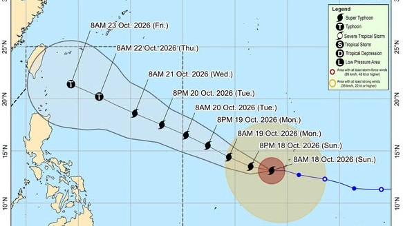
Super Typhoon Champi maintained its strength as it drew closer to the Philippine Area of Responsibility (PAR), state weather bureau PAGASA said on Sunday morning.
According to the 11 a.m. tropical cyclone advisory, Champi was last monitored 2,090 kilometers east of southeastern Luzon.
It has maximum sustained winds of 185 kilometers per hour near the center, and gustiness of up to 230 kilometers per hour.
The super typhoon is also moving westward at 25 kilometers per hour, said PAGASA.
PAGASA said that Champi is forecast to enter PAR by morning or afternoon of Tuesday, October 20. Once it enters, it will be given the local name Rosal.
"Champi is forecast to maintain its strength as Super Typhoon as it enters the PAR. After reaching its peak intensity, gradual weakening will likely commence by Tuesday," the state weather bureau said.
PAGASA added that Wind Signal No. 3 or 4 be may be the highest wind signal to be hoisted.
"Wind Signals may be hoisted over the northern and eastern portions of Northern Luzon and portions of Bicol Region as early as tomorrow (19 October) evening or Tuesday morning in anticipation of strong winds or higher associated with the upcoming TC," said PAGASA. —Vince Angelo Ferreras/RF, GMA News

