

LPA to bring rain in Visayas, Mindanao — PAGASA
The low pressure area (LPA) inside the Philippine Area of Responsibility (PAR) is expected to bring cloudy skies and rain in several areas in the country in the next 24 hours, PAGASA said Wednesday afternoon.
According to its 4 p.m. weather forecast, the state weather bureau said Eastern Visayas, Caraga, Davao Region, Bohol, Siquijor, Misamis Occidental, Misamis Oriental, and Camiguin will see cloudy skies with scattered rains and thunderstorms due to the LPA.
Meanwhile, partly cloudy to cloudy skies with isolated rain showers or thunderstorms will persist in Metro Manila and the rest of the country due to the easterlies.
PAGASA warned that these weather conditions may trigger flash floods or landslides.
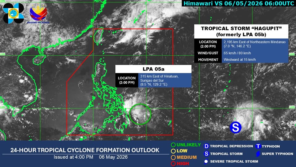
In a social media post, state meteorologists said the LPAis "unlikely" to develop into a tropical depression within the next 24 hours,
As of 2 p.m., the LPA was located 315 kilometers east of Hinatuan, Surigao del Sur.
Meanwhile, the tropical depression observed outside PAR has developed into Tropical Storm "Hagupit."
At 3 p.m, Hagupit was monitored 2,185 km east of Northeastern Mindanao.
It carries a maximum sustained winds of 65 km/h near the center and gustiness of up to 80 km/h, and is moving westward at 15 km/h.
The public is advised to monitor updates on PAGASA's official social media accounts.
State meteorologists also said winds will be light to moderate, while coastal waters will be slight to moderate throughout the country.
Sunrise in Metro Manila will be at 5:31 a.m. on Thursday. —Mariel Celine Serquiña/RF, GMA News
