

 GMA Brandtalk
 Tracking
 Archives

Domeng slightly intensifies but tropical cyclone wind signals 'less likely'
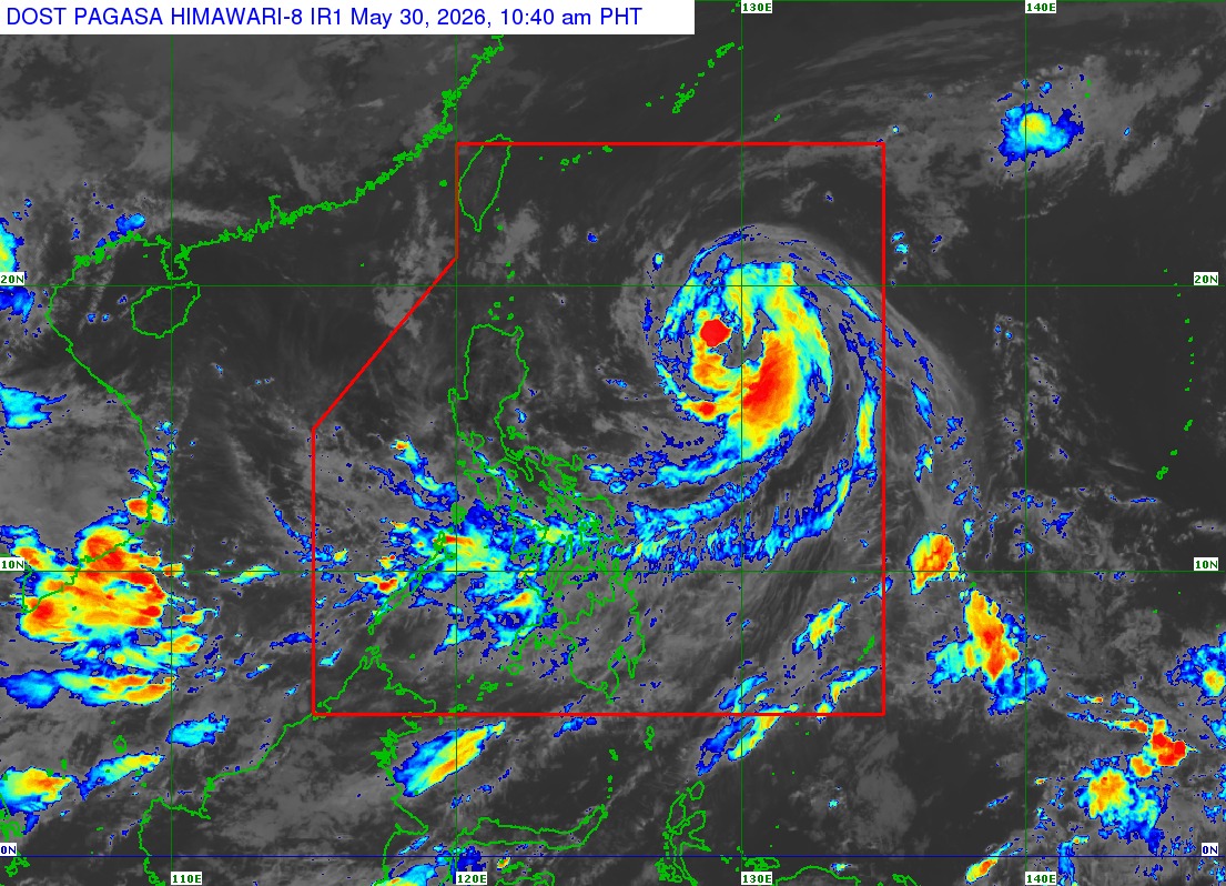
Severe Tropical Storm Domeng slightly intensifies as it moves northwestward over the Philippine Sea east of Northern Luzon on Saturday morning.
According to PAGASA's 11 am advisory, Domeng was last spotted 875 km East of Northern Luzon. It has maximum sustained winds of 100 km/h near the center, gustiness of up to 125 km/h, and central pressure of 985 hPa.
No wind signal has been raised so far.
PAGASA also says the hoisting of tropical cyclone wind signal over Extreme Northern Luzon is "less likely, but not ruled out."
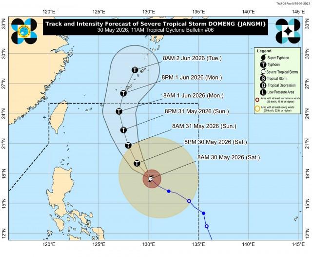
"Severe Tropical Storm DOMENG is forecast to move generally northwestward until tomorrow (31 May) before recurving towards southern Japan for the remaining forecast period. This tropical cyclone is less likely to make landfall over the country," PAGASA said in its advisory.
"DOMENG will continue to intensify and may reach typhoon category tonight or tomorrow morning while remaining over the Philippine Sea. Afterwards, it will steadily weaken but will remain as a typhoon throughout the rest of the forecast period," it added.
Domeng is likely to exit the Philippine Area of Responsibility (PAR) by Monday, according to PAGASA.
Southwest Monsoon
The Southwest Monsoon and the periphery of Domeng, meanwhile, will bring strong to gale-force gusts over the following areas on Saturday:
Most of Visayas, Batanes, Cagayan, Pangasinan, Zambales, Bataan, Tarlac, Nueva Ecija, Bulacan, CALABARZON, MIMAROPA, Bicol Region, Zamboanga del Norte, Misamis Oriental, Camiguin, Agusan del Norte, Surigao del Norte, Dinagat Islands, Sarangani, Davao Occidental, and Davao Oriental.
Most of Visayas, Batanes, Cagayan, CALABARZON, MIMAROPA, Bicol Region, Zamboanga del Norte, Misamis Occidental, Misamis Oriental, Camiguin, Agusan del Norte, Dinagat Islands, Surigao del Norte, Sarangani, Davao Occidental, and Davao Oriental are also expected to have strong to gale-force gusts on Sunday.
Rough seas are also expected over the following coastal waters:
• Up to 3.5 m: The eastern seaboard of Batanes and Babuyan Islands.
• Up to 3.0 m: The remaining seaboards of Batanes; the northern seaboard of Babuyan Islands; the eastern seaboard of Cagayan, Isabela, and northern portion of Aurora.
PAGASA warned Mariners of small seacrafts, including all types of motorbancas not to venture out to sea under these conditions, especially if inexperienced of operating ill-equipped vessels.
"Considering these developments, the public and disaster risk reduction and management offices concerned are advised to take all necessary measures to protect life and property," PAGASA said. —VAL, GMA News

