

 GMA Brandtalk
 Tracking
 Archives

LPA develops into Tropical Depression Kiyapo, Signal No. 1 raised over two areas
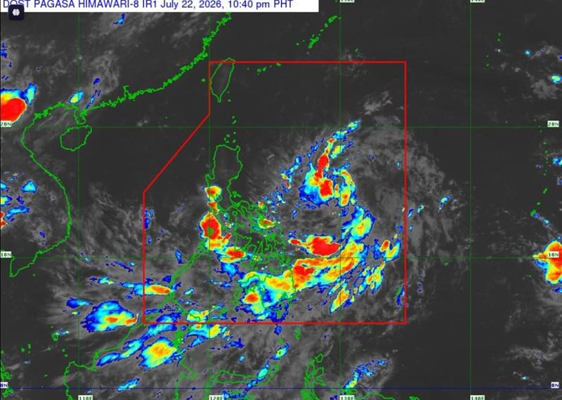
The Low Pressure Area (LPA) located in the east of southeastern Luzon has developed into Tropical Depression Kiyapo with Signal No. 1 raised over two areas, according to the Tropical Cyclone Bulletin posted by PAGASA.
As of 10 p.m., the center of Tropical Depression Kiyapo was estimated at 1,080 kilometers east of southeastern Luzon packing maximum sustained winds of 45 kilometers per hour near the center, gustiness of up to 55 km/h, and central pressure of 1004 hPa.Kiyapo is moving northwestward at the speed of 25 km/h with strong winds extend outwards up to 400 km from the center.
Tropical Cyclone Wind Signal (TCWS) No. 1 is raised over the following areas:
Luzon
- the eastern portion of mainland Cagayan (Santa Ana, Gonzaga, Lal-Lo, Gattaran, Baggao, Peñablanca, Santa Teresita, Buguey)
- the eastern portion of Isabela (Maconacon, San Pablo, Cabagan, Tumauini, Ilagan City, Divilacan, Palanan, San Mariano, Dinapigue)
Heavy Rainfall Outlook
Heavy rainfall outlook due to Tropical Cyclone Kiyapo from Thursday evening to Friday evening (July 24)(100-200 mm) in Cagayan with (50-100 mm) in Batanes, Isabela, Apayao, Kalinga, Abra and Ilocos Norte.
Heavy rainfall outlook due to Southwest Monsoon from Wednesday evening to Thursday evening (July 23) with moderate to heavy (50-100 mm): Zamboanga del Norte, Zamboanga Sibugay, Zamboanga del Sur, Lanao del Norte, Lanao del Sur, Maguindanao del Norte, Sultan Kudarat, and Sarangani.
Severe Winds
PAGASA said minimal to minor impacts from strong winds are possible within any of the areas under Wind Signal No. 1.
The enhanced Southwest Monsoon and the periphery of Kiyapo will bring strong to gale-force gusts over the following areas (especially in coastal and upland areas exposed to winds) on Wednesday in Sarangani, Davao Occidental, and Davao Oriental.
For Thursday (23 July): Most of Mindanao, Siquijor, Bohol, and Southern Leyte
Hazards affecting coastal waters
A Gale Warning may be issued tomorrow over the seaboards of Extreme Northern Luzon.
Mariners are advised not to venture out to sea under these conditions, especially if inexperienced of operating ill-equipped vessels.
Track and Intensity Outlook
"Kiyapo will move west northwestward to northwestward during the entire forecast period. It may make close approach or may make landfall over Babuyan Islands by Friday (24 July) evening," said PAGASA.
A landfall scenario over mainland Cagayan is not ruled out, the agency added.
Kiyapo will then emerge over the Luzon Strait and is forecast to exit the Philippine Area of Responsibility by Saturday (25 July) morning or noon.
"Kiyapo is forecast to gradually intensify while moving over the Philippine Sea and may reach tropical storm category by Friday. It will then continue to intensify as a tropical storm while traversing Extreme Northern Luzon and will strengthen further once it emerges over the Luzon Strait. Further intensification to severe tropical storm prior to its approach to Northern Luzon is not ruled out," the weather bureau said. — BAP, GMA News

