

 GMA Brandtalk
 Tracking
 Archives

Moderate to heavy rainshowers expected over parts of Luzon in 2 hours
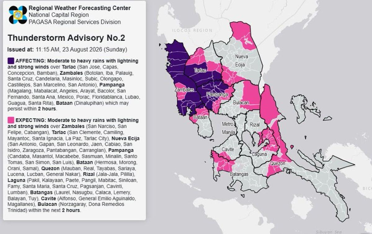
Moderate and heavy rainshowers are forecasted over several areas in Luzon in the next two hours, state weather bureau PAGASA said on Sunday.
According to a thunderstorm advisory issued at 11:15 a.m., moderate to heavy rainshowers with lightning and strong winds are expected in the next two hours over Nueva Ecija (San Antonio, Gapan, San Leonardo, Jaen, Cabiao, San Isidro, Zaragoza, Pantabangan, Carranglan), Quezon (Mauban, Real, Tayabas, Sariaya, Lucena, Lucban, General Nakar), Rizal (Jala-Jala, Pililla), Laguna (Pakil, Kalayaan, Paete, Pangil, Mabitac, Siniloan, Famy, Santa Maria, Santa Cruz, Pagsanjan, Cavinti, Lumban), Batangas (Laurel, Nasugbu, Calaca, Lemery, Balayan, Tuy), Cavite (Alfonso, General Emilio Aguinaldo, Magallanes) and Bulacan (Norzagaray, Doña Remedios Trinidad).
Meanwhile, the above conditions are being experienced in Tarlac (San Jose, Capas, Concepcion, Bamban), Zambales (Botolan, Iba, Palauig, Santa Cruz, Candelaria, Masinloc, Subic, Olongapo, Castillejos, San Marcelino, San Antonio), Pampanga (Magalang, Mabalacat, Angeles, Arayat, Bacolor, San Fernando, Santa Ana, Mexico, Porac, Floridablanca, Lubao, Guagua, Santa Rita) and Bataan (Dinalupihan) which may persist within two hours and may affect nearby areas.
The Southwest Monsoon or Habagat is affecting Luzon, bringing occasional rains over Batanes and cloudy skies with scattered rains and thunderstorms over Metro Manila, the Ilocos Region, the Cordillera Administrative Region, Central Luzon, Rizal, Cavite, Batangas, Occidental Mindoro and the rest of Cagayan Valley.
PAGASA is also monitoring three tropical cyclones outside the Philippine Area of Responsibility (PAR), among them is Typhoon Saudel which could develop into a super typhoon.
Saudel is expected to be inside PAR by Monday morning or afternoon, August 24, PAGASA said. —Vince Angelo Ferreras/KG, GMA News
