

Ulysses moves inland, now in southwestern Nueva Ecija; Signal No. 3 over 16 areas
Typhoon Ulysses continued to move inland into Luzon early Thursday.
According to the 5 a.m. weather advisory by PAGASA, the cyclone was spotted in Southwest Nueva Ecija as of 4 a.m.
The central and southern portions of Aurora, the northern portion of Quezon including Polillo Islands, Nueva Ecija, Bulacan, Tarlac, Pampanga, Pangasinan, Zambales, Bataan, Metro Manila, and Rizal will experience destructive winds and heavy to intense rainfall within the next three hours.
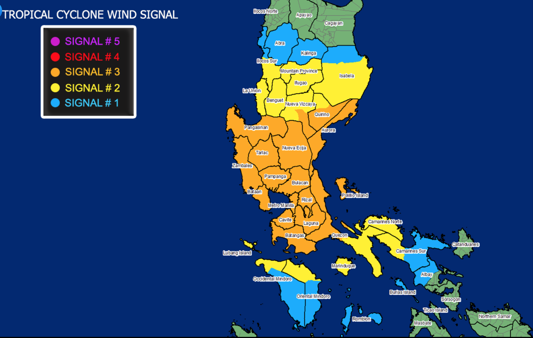
Tropical Cyclone Wind Signal (TCWS) No. 3 is up over the following areas:
- the southern portion of Quirino (Maddela, Nagtipunan)
- the southern portion of Nueva Vizcaya (Alfonso Castaneda, Dupax Del Norte, Dupax Del Sur)
- Pangasinan
- Nueva Ecija
- Aurora
- Tarlac
- Zambales
- Bataan
- Pampanga
- Bulacan
- Metro Manila
- Rizal
- Cavite
- Laguna
- Batangas
- the northern and central portions of Quezon (San Antonio, Tiaong, Dolores, Candelaria, Sariaya, Lucena City, Pagbilao, Tayabas City, Lucban, Mauban, Sampaloc, Padre Burgos, Atimonan, Perez, Alabat, Plaridel, Agdangan, Real, Infanta, General Nakar) including Polillo Islands
Tropical Cyclone Wind Signal (TCWS) No. 2 is up over the following areas:
- the central and southern portions of Isabela (Mallig, Quirino, Ilagan, Roxas, Burgos, Gamu, Palanan, San Mariano, Dinapigue, San Guillermo, Benito Soliven, Naguilian, Reina Mercedes, Luna, San Manuel, Aurora, Cabatuan, Cauayan City, San Mateo, Alicia, Angadanan, Echague, Jones, San Agustin, San Isidro, Ramon, Santiago City, Cordon)
- the rest of Quirino
- the rest of Nueva Vizcaya
- Mountain Province
- Ifugao
- Benguet
- the southern portion of Ilocos Sur (Cervantes, Quirino, San Emilio, Lidlidda, Santiago, Banayoyo, Candon City, Galimuyod, Gregorio Del Pilar, Salcedo, Santa Lucia, Santa Cruz, Sigay, Suyo, Tagudin, Alilem, Sugpon)
- La Union
- the northern portion of Occidental Mindoro (Paluan, Abra de Ilog) including Lubang Island
- the northern portion of Oriental Mindoro (Pola, Victoria, Naujan, Baco, Calapan City, San Teodoro, Puerto Galera)
- Marinduque
- the rest of Quezon
- Camarines Norte
- the western portion of Camarines Sur (Pamplona, Pasacao, Libmanan, Cabusao, Sipocot, Lupi, Ragay, Del Gallego)
Tropical Cyclone Wind Signal (TCWS) No. 1 is hoisted over the following areas:
- the rest of Isabela
- Kalinga
- Abra
- the rest of Ilocos Sur
- the rest of Occidental Mindoro
- the rest of Oriental Mindoro
- Romblon
- the rest of Camarines Sur
- the western portion of Albay (Tabaco City, Malilipot, Guinobatan, Pio Duran, Ligao City, Oas, Polangui, Tiwi, Malinao, Libon)
- Burias Island
Hazards affecting land areas
The surge of the Northeast Monsoon will bring strong breeze to gale-force winds over the rest of Northern Luzon.
Until noon on Thursday, heavy to intense with at times torrential rains will prevail over Metro Manila, CALABARZON, and Central Luzon.
Moderate to heavy with at times intense rains are expected over Cordillera Administrative Region, mainland Cagayan Valley, Babuyan Islands, Pangasinan, Marinduque, and the northern portion of Mindoro Provinces including Lubang Island.
Light to moderate with at times heavy rains may prevail over Visayas and rest of Luzon.
According the the state weather agency, flooding including flashfloods, rain-induced landslides, and sediment-laden streamflows such as lahar may occur during heavy or prolonged rainfall especially in highly susceptible areas.
A Storm Surge Warning was raised by the weather bureau as there is a high risk of storm surge with heights of up to 3 meters over the coastal areas of Aurora, northern Quezon including Polillo Islands, Cavite, Metro Manila, Bulacan, Pampanga, Bataan, and Zambales, and up to 2 meters over the coastal areas of Isabela, La Union, Pangasinan, Batangas, the rest of Quezon, Marinduque, and the northern portion of Mindoro Provinces including Lubang Island.
There is also a moderate risk of seiche or storm surge over the coastal areas surrounding Laguna de Bay.
Hazards affecting coastal waters
Within the next 24 hours, the combined effects of Typhoon Ulysses and the surge of the Northeast Monsoon will bring rough to very high seas over the seaboards of areas under TCWS and the northern seaboard of Northern Samar, rough to high seas over the remaining seaboards of Northern Luzon, and rough to very rough seas over the western seaboard of Palawan including Calamian and Kalayaan Islands and the seaboards of Bicol Region not under TCWS.
Sea travel is risky for all types of vessels over these waters.
Moderate to rough seas will be experienced over the eastern seaboards of Visayas and Mindanao, the seaboards of Cuyo Islands, and the western seaboard of Panay Island.
Mariners of small seacrafts are advised to take precautionary measures when venturing out to sea. Inexperienced mariners should avoid navigating in these conditions.
Track and intensity outlook
Ulysses will continue crossing the landmass of Central Luzon. The typhoon is forecast to emerge over the western seaboard of Zambales on Thursday morning. On the forecast track, the typhoon may exit the Philippine Area of Responsibility on Friday morning or afternoon.
The typhoon is forecast to slightly weaken while crossing Central Luzon due to frictional effects in the presence of the Sierra Madre and Zambales Mountain Ranges. However, it is likely to remain a typhoon during its traverse of the Luzon landmass.
Floods, power outage
Ulysses brought on heavy rains along with howling winds overnight over parts of Luzon, including Metro Manila, on Thursday, bringing along threats of flooding and bringing along comparisons to Ondoy.
Power outages also hit different parts of Metro Manila.
Forced evacuation was implemented in Marikina as the water level in Marikina River continued to go up.
Flooded areas were reported in Quezon, San Mateo in Rizal, and other areas.
A red alert status was also raised before dawn on Thursday over the La Mesa Dam as water level reached 79.17 meters due to heavy rains brought about by Typhoon Ulysses.
Ipo Dam conducted a spilling operation, and residents of low-lying areas including those living near the river bank of Angat River, including Norzagaray, Angat, San Rafael, Bustos, Baliuag, Pulilan, Plaridel, and Hagonoy were advised to be on alert for floodings or flash floods. —BAP/KG, GMA News
