

EXPLAINER: Why tropical cyclone Caloy quickly weakened over Philippine Sea
Tropical cyclone Caloy quickly lost strength after it entered the Philippine Area of Responsibility on May 9.
On May 10, it was downgraded to a tropical depression; the next day, it returned to a low pressure area.
PAGASA explained that the LPA would likely dissipate within five days over the Philippine Sea due to “increasingly less favorable environmental conditions.”
What are these environmental conditions?
Speaking to GMA News Online, PAGASA weather specialist Benison Estareja explained that Caloy weakened due to the vertical wind shear and dry air.
“Yung wind shear ito yung lakas ng hangin in different levels of the atmosphere, so kapag mataas ang vertical wind shear, ibig sabihin malaking difference ng hangin sa lower at upper levels ng atmosphere,” Estareja said in a phone interview on Thursday.
(Wind shear refers to the strength and change of winds at different levels of the atmosphere. When vertical wind shear is high, it means there is a large difference in wind speed or direction between the lower and upper levels of the atmosphere.)
“Sa madaling salita magulo yung hangin kaya nasisira yung circulation ng bagyo (the wind direction is chaotic, which disrupts the circulation of the tropical cyclone),” he added.
Although the warm temperature of the ocean contributes to the intensification of the low pressure area or storm, Estareja said it is not always the case.
“So mga factor ’yon, siyempre, na kapag mainit na mainit, may tendency na lumakas siya, pero may iba pang factors gaya ng wind shear na posibleng eradicate ’yung intensification,” he said.
(One of the factors is that when the sea is warm, there is a tendency for it to intensify. However, there are also other factors, such as wind shear, that can eradicate intensification.)
The surrounding air also caused Caloy to weaken, according to Estareja.
“Dun sa path ni Bagyong Caloy during that time habang nasa east siya ng ating bansa, mas tuyo ng hangin nung bagyo compared dun sa mga nasa itaas, sa mga malapit sa equator, kaya nakaka-contribute sa paghina ng bagyo,” Estareja said.
(At that time, the surrounding air along the path of tropical cyclone Caloy, while it was east of the Philippines, was drier compared to areas farther north and near the equator, which contributed to the weakening of the typhoon.)
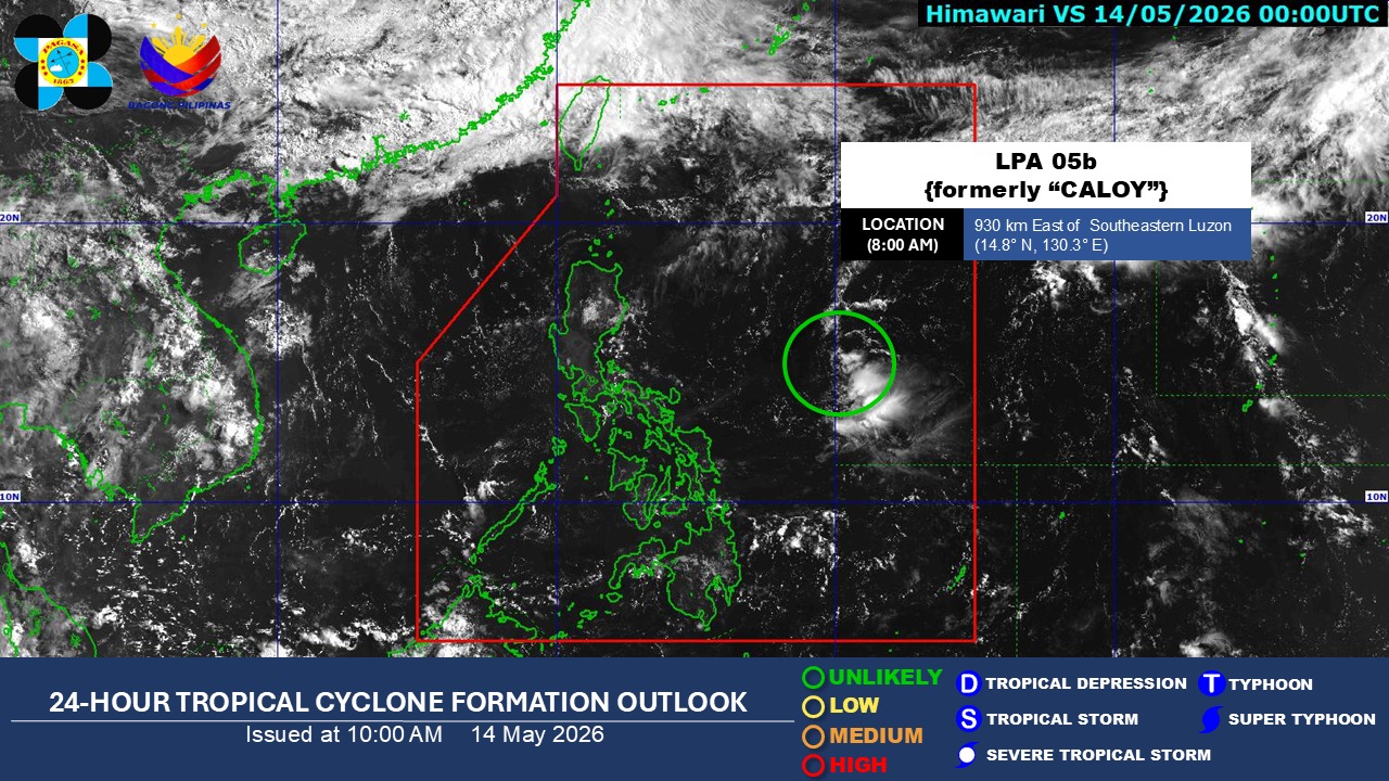
As of 8 a.m. on Thursday, the LPA (formerly Caloy) was located 930 kilometers east of Southeastern Luzon.
The state weather bureau said the LPA is "unlikely" to redevelop into a tropical depression within the next 24 hours.
“Andun pa rin yung mga weakening factor, yung mataas na wind shear and relatively dry area sa paligid ng LPA, and yung structure ng LPA ay halos kakaunting ulap yung nakikita natin, kaya walang talagang sign na ito’y mag-i-intensify,” Estareja said.
(The weakening factors are still present, including strong wind shear and a relatively dry environment around the LPA. Its structure also shows only a few cloud clusters, so there are no signs that it will intensify.) —VBL, GMA News
