

 GMA Brandtalk
 Tracking
 Archives

Tropical Depression Neneng accelerates over coastal waters of eastern Taiwan
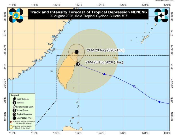
Tropical Depression Neneng picked up speed as it moved over the coastal waters of eastern Taiwan, according to PAGASA.
In its 5 a.m. cyclone bulletin, the weather bureau said that as Neneng lingers in the country, the Southwest Monsoon of Habagat will continue to bring heavy rains and strong to gale-force winds over parts of the country.
For Thursday, these conditions are expected over most of Luzon and the Visayas, as well as the Zamboanga Peninsula, Northern Mindanao and the Davao Region.
On Friday, Aug. 21, strong to gale-force gusts are forecast over most of Luzon, Panay Island, Negros Occidental, Northern Samar and Davao Oriental.
By Saturday, Aug. 22, most of Luzon and the Visayas, along with Davao Oriental, may continue to experience strong to gale-force gusts.
The center of Neneng was estimated at 390 kilometers north of Itbayat, Batanes. It is moving west northwestward at 30 kilometers per hour with maximum sustained winds of 45 km/h near the center and gustiness of up to 55 km/h.
Neneng is forecast to decelerate while moving northward. Its center may continue to move over the waters off the eastern coast of Taiwan or may make landfall over the northern portion of Taiwan. In the next 12 hours, this tropical cyclone may weaken into a remnant low, PAGASA said.
A tropical depression and Tropical Storm Saudel, which are both outside the Philippine Area of Responsibility, are also being monitored by PAGASA.
Meanwhile, the rainfall warning over Zambales and Bataan has been terminated as light to moderate rain has been observed in the areas for the past three hours.
Light to moderate rain with occasional heavy rain is affecting the towns of Morong and Bagac in Bataan, which may persist within three hours and may impact on nearby areas. —LDF, GMA News

