ADVERTISEMENT
LIVE
Filtered By: Weather
Weather

LIVE UPDATES: Habagat rains affect parts of PH on Wednesday, Aug. 19, 2026


+
Add GMA on Google
Make this your preferred source to get more updates from this publisher on Google.
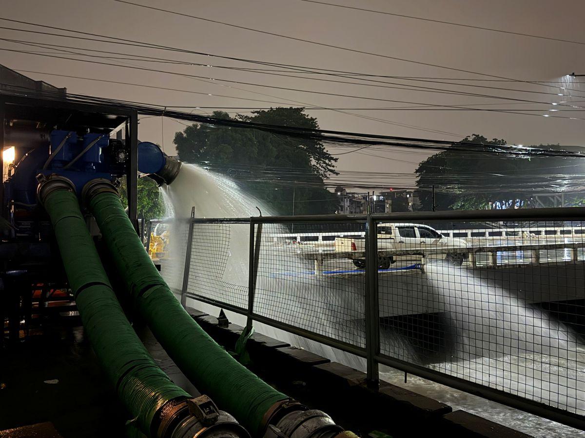
Authorities conduct pumping operations on E. Rodriguez Avenue near the corner of Araneta Avenue
Auto-refresh

LIST: Canceled flights on Wednesday, August 19, 2026 due to bad weather

Several domestic and international flights were canceled, diverted, or forced to make a go-around on Wednesday due to bad weather conditions, the Civil Aviation Authority of the Philippines (CAAP) said.

As of 9:30 a.m., the CAAP said the affected flights are the following:

Canceled

Cebu Pacific

  • 5J 472 — Bacolod to Manila, with 203 passengers
  • 5J 192 — Manila to Cauayan, with 137 passengers
  • 5J 193 — Cauayan to Manila, with 155 passengers
  • 5J 508 — Manila to Tuguegarao, with 124 passengers
  • 5J 509 — Tuguegarao to Manila, with 152 passengers

Missed approach

Central Airlines

  • HLF9849 — Zhuhai, China to Clark (diverted to Mactan)

Go-around

Jeju Air

  • JJA2107 — Seoul to Angeles

Philippine Airlines

  • PAL111 — Guam to Manila

Cebu Pacific

  • 5J 384 — Cagayan de Oro to Manila

Air Philippines

  • GAP2520 — Cagayan de Oro to Manila

—VAL, GMA News

Infra damage from Habagat, Luis, Maymay reached over ?3.5 billion —OCD

Infrastructure damage from the combined effects of Tropical Cyclones Luis and Maymay and the Southwest Monsoon or Habagat has reached more than ?3.5 billion, the Office of Civil Defense (OCD) said Wednesday.

As of 6 a.m., the OCD reported ?3,501,383,771 in infrastructure damage, while agricultural damage was estimated at ?1,423,918,790.

The weather disturbances also damaged 1,993 houses — 1,787 partially and 206 totally.

A total of 1,539,614 families or 5,394,342 individuals were affected by the bad weather in the following regions:
• Ilocos Region
• Cagayan Valley
• Central Luzon
• Bicol
• Western Visayas
• Zamboanga Peninsula
• CALABARZON
• Cordillera Administrative Region
• Metro Manila
• MIMAROPA

In 461 evacuation centers, a total of 12,194 families or 42,203 individuals were recorded.

The OCD recorded 27 deaths, 17 injuries, and one person still missing.

Benguet recorded the highest number of fatalities at 15, mostly due to landslides in La Trinidad, Baguio and Atok.

Rizal reported three deaths, while Batangas also recorded three. La Union, Quezon, Oriental Mindoro and Negros Occidental each reported one fatality. Caloocan recorded two deaths.

According to the OCD, the government has so far provided ?796,983,073 worth of assistance to affected communities. —Joviland Rita/KG, GMA News

FLOOD ALERT: Flooded roads in Metro Manila on Wednesday, August 19, 2026

Several roads in Metro Manila were reported flooded on Wednesday morning following rains, according to the Metropolitan Manila Development Authority (MMDA).

As of 9:35 a.m., the MMDA's reported flooding in the following areas:

QUEZON CITY

  • Q Avenue corner D. Tuazon — 8 inches, gutter-deep; passable to all types of vehicles.
  • Biak na Bato corner Q Avenue — 8 inches, gutter-deep; passable to all types of vehicles.
  • G. Araneta Avenue-Talayan northbound — 13 inches, half-tire deep; not passable to light vehicles.
  • G. Araneta Avenue-Talayan southbound — 13 inches, half-tire deep; not passable to light vehicles.

VALENZUELA CITY

  • MacArthur Highway in front of Toyota/Goodyear — 13 to 14 inches, half-tire deep; not passable to light vehicles.

CALOOCAN CITY

  • Rizal Avenue from 999 Mall to SM Grand Central — flooding had subsided.
  • C3-NLEX Connector intersection — 8 inches, gutter-deep; passable to all types of vehicles.

MANDALUYONG CITY

  • Boni Avenue corner F. Ortigas — 8 inches, gutter-deep; passable to all types of vehicles.

MANILA

  • Tayuman corner Abad Santos — 8 inches, gutter-deep; passable to all types of vehicles.
  • Bambang corner Avenida — 8 inches, gutter-deep; passable to all types of vehicles.
  • España-Dela Fuente westbound — 8 inches, gutter-deep; passable to all types of vehicles.

MALABON CITY

  • Gov. Pascual Avenue, Sitio 6 — 10 inches, half-knee deep; not passable to all types of vehicles.
  • M.H. Del Pilar Street, Barangay Maysilo — 10 inches, half-knee deep; not passable to all types of vehicles.
  • M.H. Del Pilar Street, Barangay Santulan — 10 inches, half-knee deep; not passable to all types of vehicles.
  • Don Basilio Bautista, Barangay Hulong Duhat — 10 inches, half-knee to knee deep; not passable to all types of vehicles.
  • Women's Club, Barangay Hulong Duhat — 8 inches, gutter-deep; passable to all types of vehicles.

— RSJ, GMA News

RAINFALL ALERT: Red in Metro Manila, Bataan, 5 areas; Orange in 7 areas; Yellow in Nueva Ecija, 7 areas (Wednesday, 8 am)

PAGASA issued a red rainfall warning over Metro Manila, Bataan, and parts of five other areas in Luzon Wednesday morning due to inclement weather brought by the Southwest Monsoon, or Habagat.

As of 8 a.m., the following areas were under rainfall warnings:

Red Rainfall Warning — Serious flooding in flood-prone areas

  •     Bataan,
  •     Metro Manila,
  •     Zambales (Cabangan, San Felipe, San Antonio, San Narciso, Botolan, San Marcelino, Olongapo, Subic, Castillejos),
  •     Bulacan (Marilao, Bocaue, Bulakan, Meycauayan, Obando, Balagtas, Hagonoy, Paombong, Malolos, Calumpit, Guiguinto, Pulilan, Plaridel),
  •     Pampanga (Masantol, Sasmuan, Macabebe, Lubao, Floridablanca),
  •     Batangas (Nasugbu, Lian, Calatagan, Balayan, Tuy) and
  •     Cavite (Ternate, Maragondon, Naic, Tanza, Rosario, Cavite City, Noveleta, Bacoor, Kawit, Magallanes, General Emilio Aguinaldo, General Trias, Imus, Trece Martires).

Orange Rainfall Warning — Flooding is still threatening

  •     Zambales (Candelaria, Masinloc, Santa Cruz, Palauig, Iba),
  •     Bulacan (Angat, Baliuag, Bustos, San Jose del Monte, Norzagaray, Pandi, San Ildefonso, San Rafael, Santa Maria),
  •     Pampanga (Apalit, Bacolor, San Fernando, Mexico, Minalin, San Luis, San Simon, Santa Ana, Santo Tomas, Angeles, Guagua, Porac, Santa Rita, Mabalacat),
  •     Rizal (Rodriguez, San Mateo, Antipolo, Taytay, Angono, Cainta, Teresa, Morong, Baras, Cardona, Binangonan),
  •     Tarlac (San Jose, Capas, Bamban, Mayantoc), Cavite(Alfonso, Amadeo, Indang, Mendez, Silang, Tagaytay, Carmona, Dasmarinas, Gen. Mariano Alvarez),
  •     Laguna (San Pedro, Binan, Santa Rosa, Cabuyao, Calamba) and
  •     Batangas (Calaca, Laurel, Lemery, Agoncillo, Tingloy, Mabini, Bauan, San Luis, Taal, San Nicolas, Santa Teresita, Talisay, Tanauan).

Yellow Rainfall Warning — Possible flooding in flood-prone areas

  •     Nueva Ecija,
  •     Rizal (Tanay, Pililla, Jala-Jala),
  •     Tarlac (Concepcion, Anao, Tarlac City, Gerona, La Paz, Paniqui, Pura, Ramos, San Manuel, Victoria, Camiling, Moncada, San Clemente, Santa Ignacia),
  •     Pampanga (Arayat, Candaba, Magalang),
  •     Bulacan (Dona Remedios Trinidad, San Miguel),
  •     Quezon (General Nakar, Panukulan, Burdeos, Polillo, Patnanungan, Jomalig, San Antonio, Tiaong),
  •     Batangas (Malvar, Santo Tomas, Alitagtag, Balete, Batangas City, Cuenca, Ibaan, Lipa, Mataasnakahoy, San Jose, San Pascual, Lobo, Padre Garcia, Rosario, San Juan, Taysan) and
  •     Laguna (Los Banos, Bay, Alaminos, Calauan, Victoria, San Pablo).

Areas experiencing light to moderate rains, with occasional heavy rains, which may persist within three hours and affect nearby areas :

  •     Quezon (Candelaria, Dolores, Sariaya, Tayabas, Infanta, Lucban, Lucena, Mauban, Pagbilao, Real, Sampaloc) and
  •     Laguna(Liliw, Luisiana, Magdalena, Majayjay, Nagcarlan, Pagsanjan, Pila, Rizal, Santa Cruz, Cavinti, Famy, Kalayaan, Lumban, Mabitac, Paete, Pakil, Pangil, Santa Maria, Siniloan) 

PAGASA advised the public and the concerned Disaster Risk Reduction and Management Offices to monitor weather conditions and watch for the next warning to be issued at 11 a.m. Wednesday.

WALANG PASOK: Class suspensions for Wednesday, August 19, 2026

Classes for Wednesday, August 19, 2026, have been suspended in some schools and areas.

Click this link to see the list of schools and areas that have suspended classes. —KG, GMA News

RAINFALL ALERT: Red in Bataan, parts of Zambales, Cavite, Batangas; Orange in Pampanga; Yellow in Metro Manila (Wednesday, 5 am)

PAGASA issued a red rainfall warning over Bataan and parts of Zambales, Cavite, and Batangas early Wednesday due to heavy rains brought by the Southwest Monsoon, or Habagat.

As of 5 a.m., the following areas were under rainfall warnings:

Red Rainfall Warning — Serious flooding in flood-prone areas

  •     Bataan
  •     Zambales: Castillejos, Subic, Olongapo, San Antonio
  •     Cavite: Ternate, Maragondon, Alfonso, General Emilio Aguinaldo, Magallanes
  •     Batangas: Nasugbu, Lian, Calatagan, Balayan, Tuy

Orange Rainfall Warning — Flooding is still threatening

  •     Zambales: Botolan, San Marcelino, Cabangan, Iba, Masinloc, Palauig, San Felipe, San Narciso, Candelaria, Santa Cruz
  •     Tarlac: Mayantoc, San Jose, Capas, Bamban, Concepcion, Tarlac City, Santa Ignacia, San Clemente, Camiling, Gerona, La Paz
  •     Pampanga: Floridablanca, Lubao, Sasmuan, Apalit, Arayat, Bacolor, San Fernando, Macabebe, Magalang, Masantol, Minalin, San Luis, San Simon, Santa Ana, Santo Tomas, Angeles, Mabalacat, Guagua, Porac, Santa Rita, Mexico
  •     Cavite: Amadeo, General Trias, Indang, Mendez, Silang, Tagaytay, Trece Martires, Bacoor, Carmona, Cavite City, Dasmariñas, General Mariano Alvarez, Imus, Kawit, Naic, Noveleta, Rosario, Tanza
  •     Batangas: Ibaan, Batangas City, Lipa, Santo Tomas, Tanauan, Malvar, Mataasnakahoy, Talisay, Balete, Laurel, Agoncillo, Lemery, Calaca, Taal, San Nicolas, Santa Teresita, Alitagtag, Cuenca, San Jose, San Pascual, Bauan, San Luis, Mabini, Tingloy
  •     Bulacan: Hagonoy, Calumpit, Paombong

Yellow Rainfall Warning — Possible flooding in flood-prone areas

  •     Metro Manila
  •     Rizal
  •     Nueva Ecija: Gabaldon, General Tinio, Bongabon, Laur, Rizal, Cabiao, Gapan, San Antonio, San Isidro, Aliaga, Cabanatuan, Cuyapo, General Mamerto Natividad, Guimba, Jaen, Licab, Llanera, Nampicuan, Palayan, Peñaranda, Quezon, San Leonardo, Santa Rosa, Santo Domingo, Muñoz, Talavera, Talugtug, Zaragoza
  •     Batangas: San Juan, Rosario, Padre Garcia, Taysan, Lobo
  •     Quezon: General Nakar
  •     Tarlac: Anao, Paniqui, Pura, Ramos, San Manuel, Victoria, Moncada
  •     Pampanga: Candaba
  •     Bulacan: Angat, Balagtas, Baliuag, Bocaue, Bulakan, Bustos, Malolos, Meycauayan, San Jose del Monte, Doña Remedios Trinidad, Guiguinto, Marilao, Norzagaray, Obando, Pandi, Plaridel, Pulilan, San Ildefonso, San Miguel, San Rafael, Santa Maria

Areas experiencing light to moderate rains, with occasional heavy rains:

  •     Nueva Ecija: Carranglan, Lupao, Pantabangan, San Jose
  •     Quezon: Infanta, Real
  •     Laguna: Biñan, San Pedro, Santa Rosa, Cabuyao, Calamba, Los Baños, Bay, Calauan, Alaminos

The rains in these areas may persist within the next three hours and could affect nearby areas. —VBL, GMA News

Permanent evacuation centers in QC pushed

Quezon City Councilor Alfred Vargas is pushing for the swift establishment of permanent evacuation centers in all six legislative districts of the city, saying dedicated shelters are needed to ensure the safety and dignity of residents during disasters.

Vargas co-authored Proposed Ordinance No. 23CC-229, or the Quezon City Permanent Evacuation Center (PEC) Ordinance, with Councilor Julienne Alyson Rae Medalla.

The proposed measure calls for the construction of climate-resilient shelters in all six legislative districts that can withstand strong tropical cyclones and earthquakes.

Each facility would have family sleeping quarters, separate restrooms for men, women, and LGBTQ+ residents, community kitchens, laundry hubs, and lactation spaces.

The evacuation centers would also include healthcare and accessibility features such as on-site medical clinics, ramps, Braille signage, and specialized fixtures for persons with disabilities (PWDs) and senior citizens.

The proposed ordinance also calls for the identification and selection of PEC sites in partnership with the University of the Philippines Nationwide Operational Assessment of Hazards (UP-NOAH) Center. This is intended to ensure that the structures are located outside high-risk hazard zones and near key healthcare facilities.

Vargas also commended Quezon City Mayor Joy Belmonte for the city's flood-control initiatives, particularly the operational detention basins at the Quezon Memorial Circle and G. Araneta, as well as covered courts serving as detention facilities in Barangay Tatalon and Palmera Homes in Barangay Sta. Monica.

Three additional retention projects are underway in Barangays Bahay Toro, Sauyo, and Greater Lagro, which are expected to further reduce urban flooding.

“We have come a long way in ensuring the safety and welfare of QCitizens during disasters. However, the Southwest Monsoon, or Habagat, showed that we need long-term solutions to make Quezon City truly disaster-resilient,” Vargas said.

“Until we reach that point, we must address the immediate, life-saving needs of QCitizens whenever disaster strikes,” he added. —VBL, GMA News

EXPLAINER: Why Mindanao is sweltering as heavy rains drench Luzon, Visayas

Since the country entered the rainy season in June, parts of Luzon and the Visayas have been repeatedly drenched by heavy rains, disrupting daily activities, flooding communities, and prompting class suspensions.

Other parts of the country, however, are experiencing the opposite weather conditions.

From last week through early this week, classes were suspended in parts of Mindanao—not because of flooding, but due to high heat indices that reached PAGASA’s “danger” category (42°C to 51°C), which can cause heat cramps, heat exhaustion, and heat stroke.

So why is Mindanao experiencing hot and dry conditions while parts of Luzon and the Visayas are being battered by heavy rains?

PAGASA weather specialist Chenel Dominguez told GMA News Online that the disparity is normal because of the Philippines’ size and varying climate patterns.

She said that the country has four climate types, and Mindanao does not have a distinct wet season.

“We have four climate types, and Mindanao does not have a distinct wet season. So when the rainy season begins in Luzon and the Visayas, it does not mean it is also the rainy season in Mindanao,” Dominguez said.

This explains why Mindanao can experience hotter conditions during the Habagat season, which typically affects the western sections of Luzon and the Visayas, she added.

“That is why they are experiencing hot weather right now—because they are not being affected by the Southwest Monsoon, or Habagat,” Dominguez said.

Dominguez also said El Niño has caused tropical cyclones to recurve away from the country instead of moving closer to land.

“Because of El Niño, tropical cyclones tend to recurve. They don't move close to our landmass, so the Habagat is more likely to be oriented toward Luzon and the western sections of the Visayas,” she said.

ITCZ

According to PAGASA, rainfall in Mindanao is usually influenced by the Intertropical Convergence Zone (ITCZ), which is currently not affecting the region.

“Usually, the ITCZ, or Intertropical Convergence Zone, is what brings rain to Mindanao. Currently, Mindanao is not being affected by the ITCZ, which is another reason why they are experiencing hot weather,” Dominguez said.

“Once the ITCZ develops and is oriented toward Mindanao, they may experience rainfall,” she said.

The ITCZ is a region where the trade winds from the Northern and Southern Hemispheres converge. According to PAGASA, it is among the weather systems that can trigger the formation of low pressure areas and tropical cyclones.

In the coming days, PAGASA forecasts rainfall mainly over the Zamboanga Peninsula.

Dominguez also said there have been instances when the Habagat affected the entire Philippines, particularly when a tropical cyclone enhancing the monsoon was near the country's landmass.

“There have been past instances when the entire Philippines was affected by the Southwest Monsoon, particularly when a tropical cyclone was close to our landmass,” she said. “When that happens, Mindanao can also experience rainfall." —Lyjah Tiffany Bonzo/VBL, GMA News


Senate allows WFH for staff without plenary duties on Aug. 19, 2026

Senate officials and employees who are not directly involved in Wednesday's plenary session are authorized to work from home on Aug. 19, 2026, Senate Secretary Renato Bantug Jr. said.

The work-from-home arrangement was directed by Senate President Sherwin Gatchalian, taking into consideration Memorandum Circular No. 129 issued by the Office of the President on Tuesday.

Malacañang instructed schools and government offices in the National Capital Region and other areas affected by the Southwest Monsoon or Habagat to shift to alternative work arrangements on Wednesday.

Bantug said heads of offices of the Office of the Sergeant-at-Arms, Legislation, External Affairs and Relations (Special Services), Management and General Services Bureau, Media and Documentation Bureau, Public Relations and Information Bureau, Enterprise Data Processing-Management Information Systems, and Senate Management Unit were directed to submit a list of essential personnel who need to report for work in connection with Wednesday's plenary session.

Work arrangements for Senate proper employees will be left to the discretion of their respective senators, according to the advisory.

Bantug said another advisory would be issued if circumstances warrant the cancellation of Wednesday's plenary session.

The Senate impeachment court earlier on Tuesday suspended the trial of Vice President Sara Duterte due to the continuous rains caused by the Southwest Monsoon (Habagat). —LDF, GMA News

TD Neneng slightly intensifies; Habagat to prevail over Luzon, 2 other areas

Tropical Depression Neneng slightly intensified as it continued to move over the waters off Batanes, state weather bureau PAGASA said in its 5 a.m. Wednesday bulletin.

As of 4 a.m., Neneng was located 675 kilometers east of Itbayat, Batanes, packing maximum sustained winds of 55 km/h near the center and gustiness of up to 70 km/h.

It was moving northwestward at 15 km/h.

PAGASA said Neneng is expected to make landfall along the eastern coast of Taiwan between Thursday afternoon and Friday morning.

“Neneng will remain a tropical depression in the next 36 hours before weakening into a remnant low over or near Taiwan on Friday morning. However, earlier weakening into a remnant low is not ruled out,” PAGASA said.

Meanwhile, the Southwest Monsoon (Habagat) will prevail over Luzon, Antique, and Aklan, bringing cloudy skies and rains in the next 24 hours.

Mindanao and the rest of Visayas will experience localized thunderstorms.

Moderate to strong winds and moderate to rough seas are expected over the northern and western sections of Luzon.

Moderate winds and moderate seas are forecast over the eastern section of the Philippines.

The rest of the country will experience light to moderate winds and slight to moderate seas. —VBL/KG, GMA News